Rangliste
Beliebte Inhalte
Anzeigen von Inhalten mit der höchsten Reputation auf 20.01.2020 in allen Bereichen
-
Man verzichtet doch nicht. Man tauscht. Komfort im Camp gegen Komfort auf dem Trail. UL-Backpacking ist nicht entstanden, weil die Leute sich zu gut gefühlt haben und deswegen Lust auf Selbstkasteiung bekamen, sondern weil es verdammt anstrengend ist Zeug durch die Gegend zu schleifen.7 Punkte
-
Soonwaldsteig - 5 Tage im Hunsrück
Schwefelfell und 3 andere reagierte auf Wanderfisch für Thema
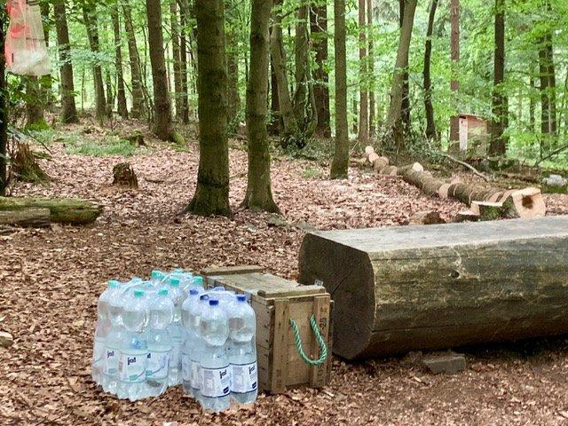
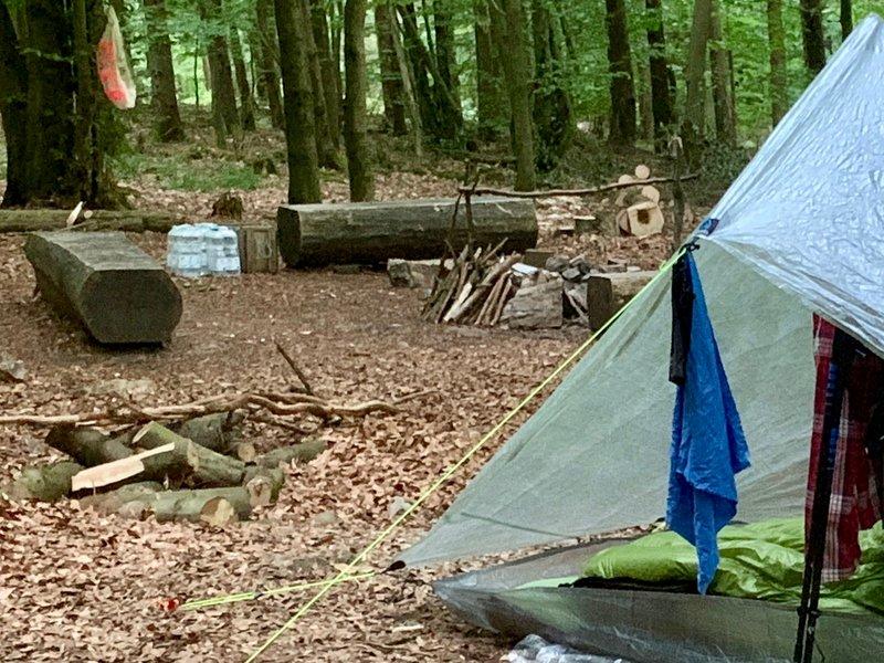
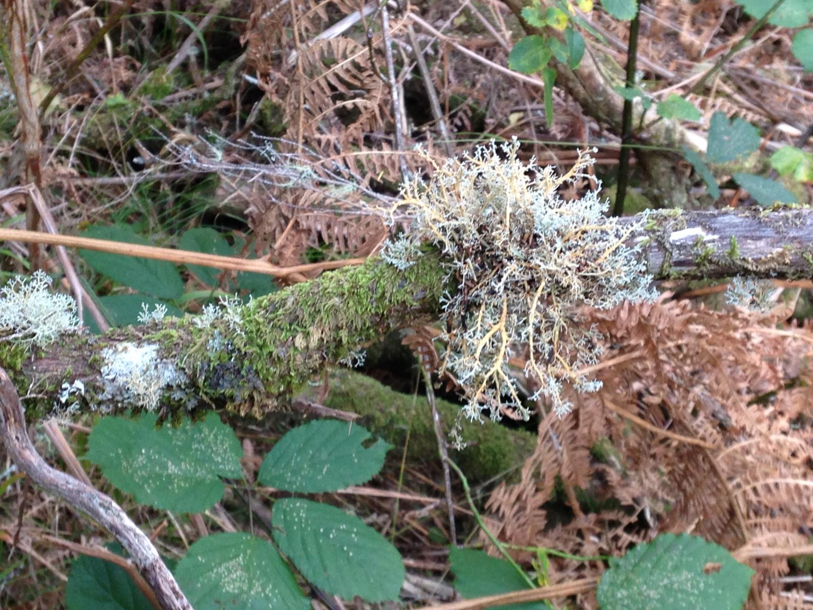
So dramatisch war's doch nicht... Wasser gab's z.B. in der Nähe der Schmidtburg. Am Friedhof in Schwarzerden (kleiner Umweg nötig) Am Trekkingplatz Alteburg gab's Wasser in Flaschen mit und ohne Kohlensäure (Luxus!) gegen Spende von 1€ mit besten Grüßen vom Förster Weiterhin auf dem Klo der Lauschhütte, wo man auch sein Camp aufschlagen und über Nacht das WC benutzen darf. (übrigens leckere Küche!). Nicht zu vergessen, das Netz offener Wasserhähne https://www.soonwaldsteig.de/service/netz-offener-wasserhaehne Aber ein klein bisschen Abenteuer war es schon 4 Punkte
 -
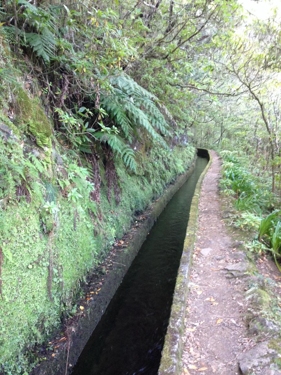
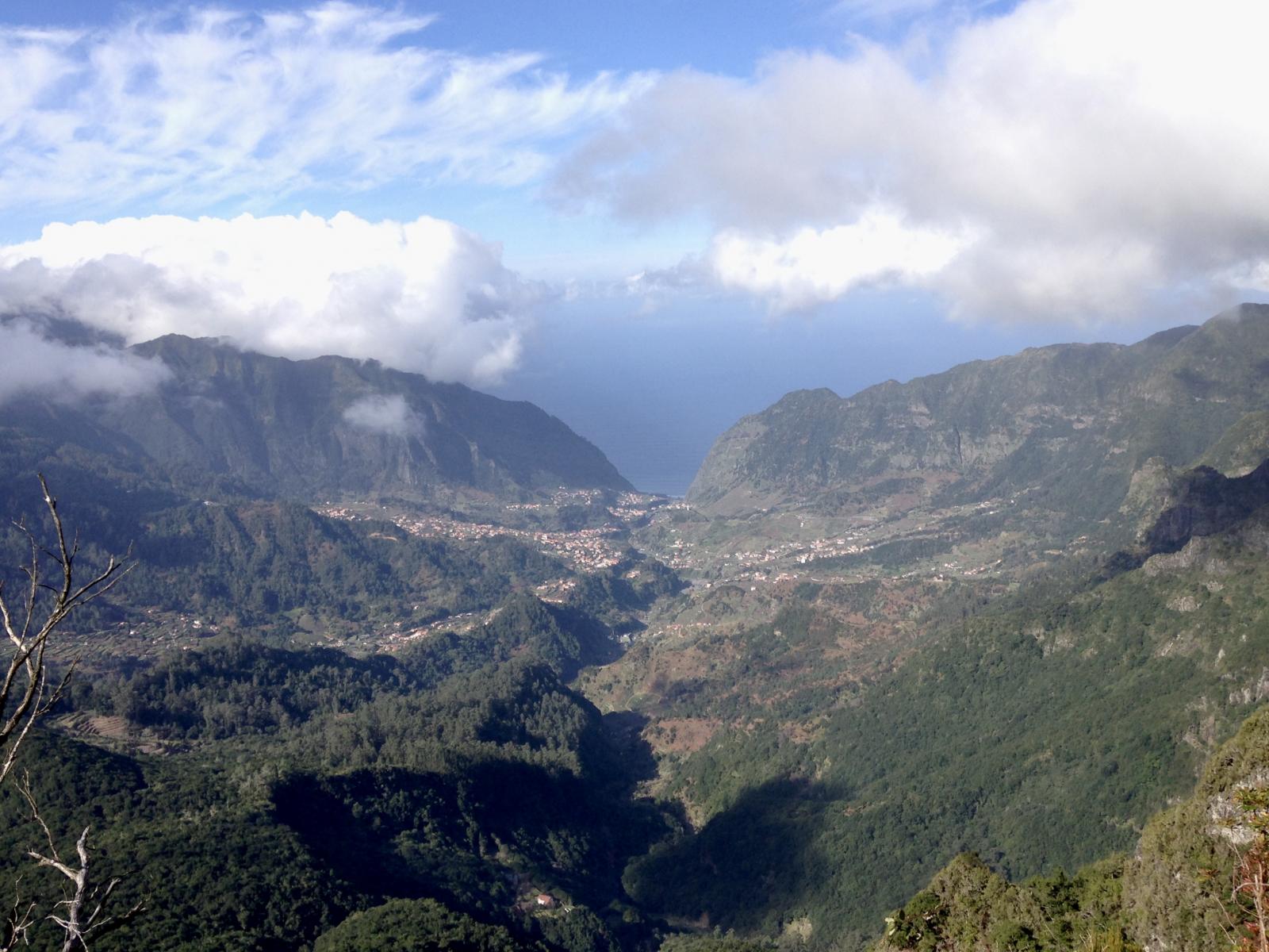
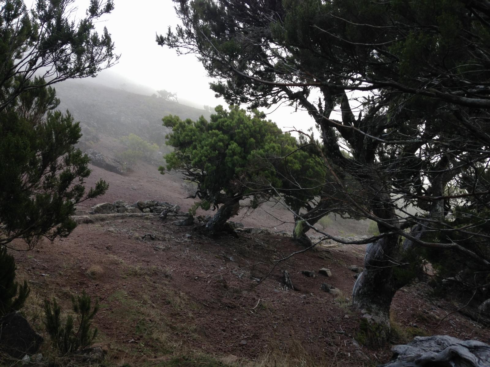
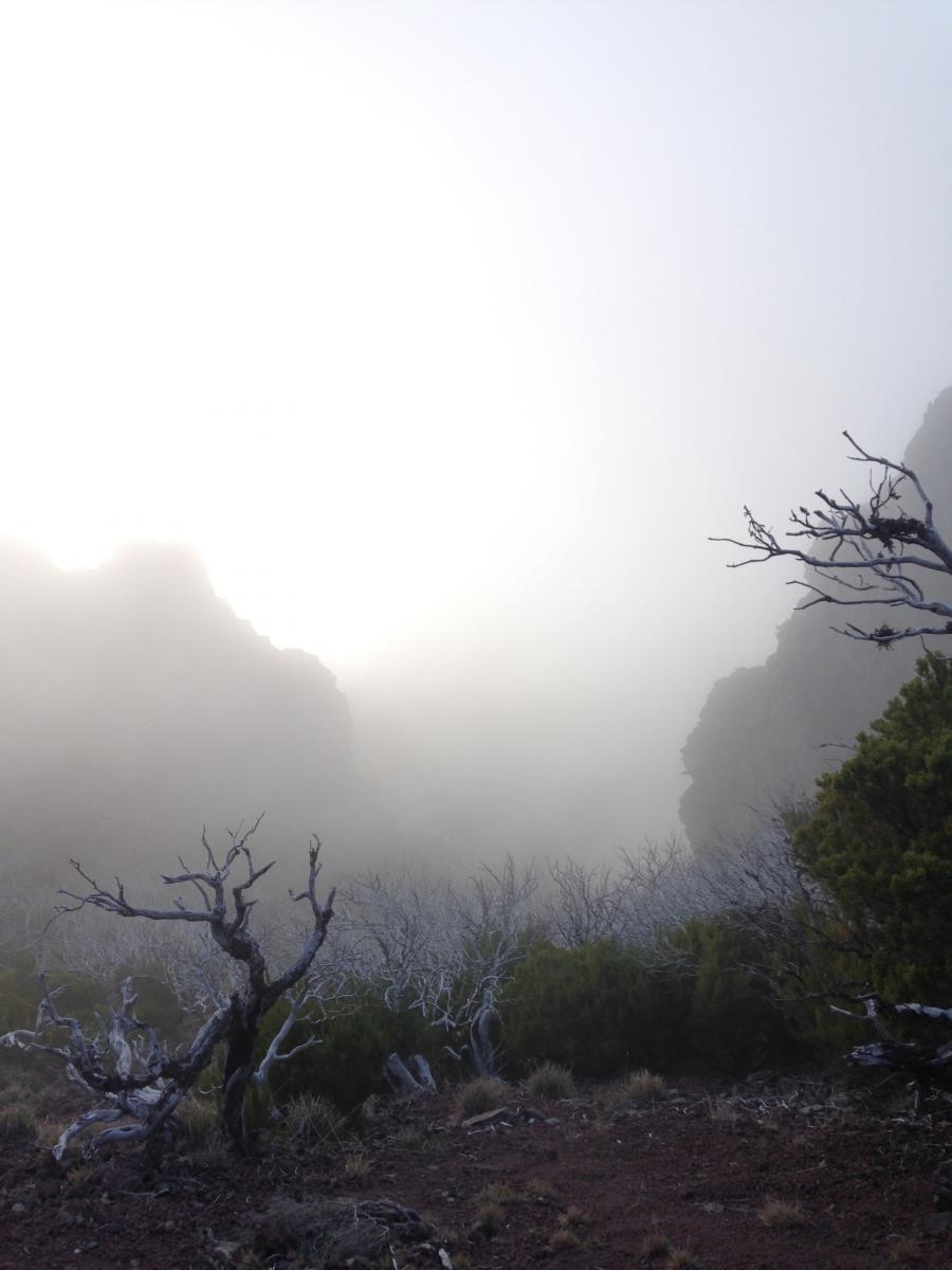
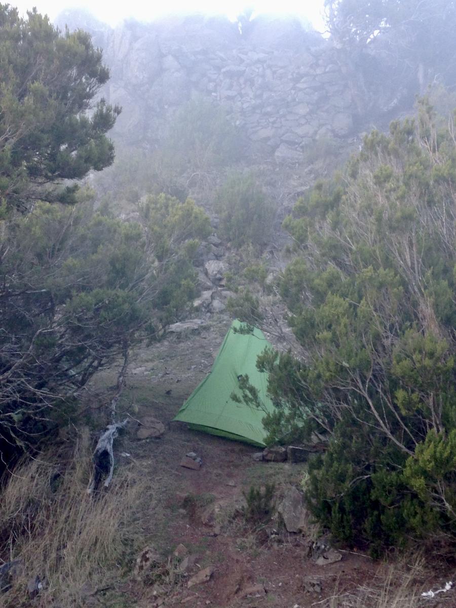
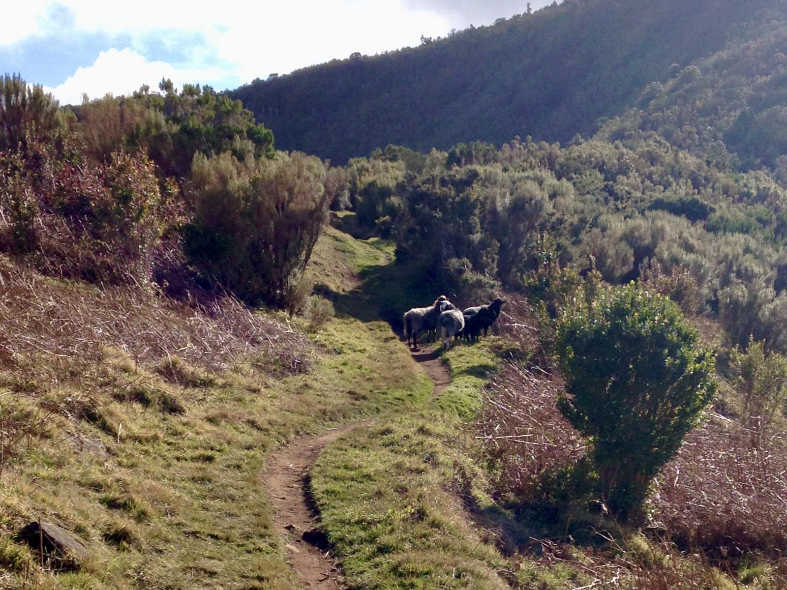
Tag 7: Nach Porto Moniz Trotz der feucht-kalten Umgebung habe ich irgendwann tief und fest geschlafen. Als ich aufwache, regnet es wieder oder es tropft der Baum… das eine vom andern ist schwer zu unterscheiden. Es ist auch immer noch windig… Ich drücke ganz fest die Augen zu. Nicht aufmachen, denke ich. In meiner embryonalen Schlafhaltung will ich mich einfach nicht bewegen, gerade ist mir so schön warm. Zumal es links und rechts des Sacks etwas nass ist, vor allem rechts am Eingang wo das Mesh ist. Ich habe es abends schon bemerkt, aber mich bemüht, mich davon nicht verrückt machen zu lassen. Nützt ja eh nix. Es ist zumindest über Nacht nicht viel mehr geworden. Keine Ahnung, woran es liegt. Von dem nicht ordentlich straffen Mesh, das auch nicht 100% senkrecht ausgerichtet ist. Dies könnte dazu führen, dass sich die Luftfeuchtigkeit daran verfängt und nach innen tropft? Der Bathtube-Boden (oder wie heißt das?) ist nicht ordentlich aufgerichtet, dadurch kommt durch den Reißverschluss unten Wasser rein? Glaube ich aber eher nicht. Abgedichtet ist es überall ordentlich… Am liebsten wär mir natürlich, es läge an den Umständen… Wenn die Luft so voller Wasser ist, ist es ja kein Wunder, dass sich die Feuchtigkeit irgendwo absetzt… rede ich mir zumindest ein. Trotzdem, nächstes mal ordentlicher und mehr in Ruhe aufbauen, egal wieviel Wind. Irgendwann klingt es draußen etwas besser und ich schaue auf die Uhr: So langsam kann ich mal zusammenpacken. Will unbedingt aus diesem anstrengenden Nebel-Wind-Wasser-Wetter raus - Immer noch sehe ich im Licht meiner Lampe die Luftfeuchtigkeit. Als ich soweit bin, dass das Zelt dran ist (so früh war ich noch nie), ist es noch stockdunkel. Dichtester Nebel. Also nochmal ins Zelt und etwas warten. Dämmern sollte es schon. Viertel vor 8 wage ich es. Zur Not kann ich in dem Unterstand noch etwas warten. Ich laufe los, es regnet nicht, aber Nebel nach wie vor. Ich denke (hoffe), mit jedem Meter Abstieg wird es heller, na ja, ein wenig. Es geht lange an einer Levada entlang durch einen Wald, das bedeutet, entspanntes Gehen. Irgendwann ist Ribeira ausgeschildert und es geht durch den Wald einen Weg, der aus mit Holzbohlen angedeutete Stufen besteht - und immer wieder durch Matsch, einmal sinke ich ganz schön tief ein, Mist. Als ich aus dem Wald rauskomme, eröffnet sich der Blick auf das Meer und etwa blauer Himmel. Hach wie schön… Und ich sehe wieder erste Anzeichen dörflicher Strukturen. Bis Porto Moniz geht es aber noch auf steilen Asphalt-Wege, die in der Mitte winzige Stufen haben, das soll das Gehen wohl erleichtern. Als ich nach Ribeira de Janela runter laufe, sehe ich von oben den Campingplatz, ein Zelt und eine Person ist zu sehen, sie hängt gerade ihr Handtuch in die Sonne. Ist es Antje? - hm, nicht sicher, aber eindeutig ein UL-Zelt (milchig-halbtransparent weiß…). Tja, sollte ich da jetzt auch stehen, in grün? Aber mal ehrlich.., so zwischen den Autostrassen... so nice ist der Platz nu auch wieder nicht - zumindest versuche ich so mir meine Hotelnacht zu legitimieren. Schade, hätte gern mit ihr etwas geplaudert, aber vielleicht sehe ich sie ja morgen nochmal. Ehrlich gesagt, freue ich mich auf eine heiße Dusche und ein profanes Hotel-Frühstück bis in die Puppen. Im Hotel folgen Tätigkeiten in der Reihenfolge: 1. Heiß duschen, 2. Klamotten waschen (irgendwann ist auch Merino durch. Müffelt mittlerweile alles ziemlich…). 3. Zelt und Quilt trocknen. 4. ESSEN... Die restlichen Tage… Ich beschloss (in Fanal?), die restlichen, verbleibenden 2 oder 3 Tage relaxt und easy wieder Richtung Funchal zu zuckeln (mit Bus und zu Fuß). Eine Nacht in einem abgelegenen Casa Rural (Langasthof) oberhalb der Küste mit Blick auf das Meer, von da aus gehe ich nochmal ein Stück die Levada Nova - das ist jedoch relativ unspektakulär und führt zum Teil durch besiedeltes Gebiet, aber gehört vielleicht auch dazu. In Prazeres (Regenwetter), stolpert Frau Antje plötzlich nochmal in das charmanten, winzigen Café, in dem ich mich aufwärme, und das von jungen Leuten mit viel Liebe und architektonischem Händchen - sicher in Eigenarbeit - ausgebaut wurde. Hoffentlich kommt hier in diesem abgelegenen Nest häufiger mal jemand vorbei. Wir tauschen uns über die letzten Nächte und Zeltplätze aus (sie hat erst ca. 3 km nach Fanal gezeltet, auch wenn mir nicht klar ist, wo da ein Platz gewesen sein soll - ich hatte am nächsten Tag geguckt. Sie sagt was von Picknickbänken… hm, könnte sein, dass ich was gesehen hab. Dort wars wohl angenehmer) und ich erblasse etwas, wie sie unterwegs ist und wie easy sie Plätze für das Zelt findet (das Cuben-Zelt war tatsächlich ihres). Versuche mir noch was abzugucken (sie eruiert wohl viel über die Karte). Irgendwie höre ich zwischendurch raus, dass sie auch als Trekking-Guide im Himalaya arbeitet? Na dann… In den lauschigen Tagen schaue ich viel aufs Meer. Genieße auch das, hatte ich auch lange nicht mehr, ich könnte nun die Runde auch wieder von vorn beginnen. Wie schnell ist die ein oder andere „Strapaze“ vergessen. Schon nach dem Tag in Moniz war ich eigentlich wieder fit, ein Pausentag hätte gereicht - das hätte ich in Fanal nicht gedacht. An der Küste scheint die Sonne und oben in den Bergen hängen schwarze Wolken, insofern ist es vielleicht auch gut so wie es ist… Aber fürs nächste Mal nehme ich diese Erkenntnis mit. Als ich die Tageswanderer im Hotel sehe, denke ich: Was für eine tolle Tour hast du gemacht und ich wollte nicht tauschen. Frau Antje war noch 1 weitere Woche unterwegs. Wieder in Funchal, letzter Abend, Sundowner in einer netten Bar etwas oberhalb...
4 Punkte
-

Pakistan Trekking 2018
Christian Wagner und 2 andere reagierte auf thedutch für Thema
Hallo Trekking Community, da Deutsch nicht meine Muttersprache ist und es für mich einfacher ist auf Englisch zu schreiben hier mein Reisebericht zum Trekking tour in Pakistan im Sommer 2018 mit mein Freund Davide. Viel spass beim Lesen. We are (David and Davide) and have been friends for a long time. The idea of this trip started many years ago as I (David) travelled through Pakistan in the mid-nineties. From that moment on I have always longed to go back to this fascinating wild country with beautiful mountains and hospitable people. As alone is no fun I asked my friend Davide to come along on the trip and as you can read in my blog, he did! Davide and David with Hunza valley Our Intention: Cross the Thui pass to Darkot (upper Yasin valley) from there cross the Panji pass to Ishkoman valley, continue the trek to Naltar valley and from there cross over to the village of Sherqilla. On our first day in Pakistan, Chitral police told us that we could not cross Thui pass due to security. Luckily I had plan “B” so we went for the Nazbar pass that would also get us to Darkot. But as you can read things worked out a “little” different. Day 1.We flew from Frankfurt to Istanbul were we had a connecting flight to Islamabad. Arrived in Islamabad early morning 3:45 as pre-arranged by a friend we were picked up by our driver Ashgar who would take us to Chitral. But first we needed some money and it was not very obvious where the ATM machines where hidden in the airport. But after a bit of asking we were shown by two heavy armed guards in what corner they were hidden. After finding out that Mastercard didn´t do the job but Visa did we left the airport for our Toyota corolla. The first bit of travel was in the dark but then slowly we got our first glimpse of Pakistan. We drove to Malakand were we encountered the Pakistani police check post and were to find out that there were many more to follow. For Davide it was the first time to Pakistan and for him it was just like driving through a documentary with three slight differences and These were; you could smell , feel the heat and last but not least the dust in your face. Our driver was a kind of mixture between Niki Lauda and Michael Schumacher and he would drive as fast as the car would and overtake other traffic where he could. No faces smiled at him during some of his moves. Slowly driving in to the mountains it got les sticky and more scenic. We passed a few police post and handed out photo copies of passport and visa as if they were more important than our actual passports. When we got close to Dir I got a bad feeling at another police post were the officer required a NOC (non objective certificate) .Without an NOC we could not continue our journey. I tried to convince him that no more NOC for travel to Chitral is needed for foreigners but he did not believe me. Why did I not take a newspaper print with that Information! In the end Ashgar conviced him that we did not need the NOC. Ok we could travel on but the officer told us don´t stop or get out in Dir. So of we went up to the Lowari tunnel, of course with passing through a few more checkpoints. The mountains in this area are still forested and are a real pretty sight. Lot of beggars on every corner of the way with little plastic basket were people can drop a few rupee´s. On these steep mountain cliffs with no room for agriculture and no industry present it must be hard for the people here to earn money. What are all the kids going to do when they grow up? The Lowari tunnel (8km) that has only been finished a few years has less than 10% of the lights in order and as lots of Pakistani cars and trucks don´t have functioning lights it is a pretty scary thing driving through a tunnel with the feeling a car or truck could just bump into you. Finally we made it out of the tunnel and we had a feeling of looking in to the holy land. Driving towards Chitral the land got more and more barren and spectacular. Eroded cliffs and the “Chitral” river far below. Ashgar please don´t make a mistake or break an axel because we don´t want to end up down there (dead). Two hours before Chitral we had a lunch break and for Davide it was quit an (first) experience having lunch while all other men (no woman) in the room watched us foreigners. Of course I didn´t take long for the first guys to ask us where are we from and and and…Davide felt at ease! Arriving in Chitral the first thing was that Asghar took us to the police Station because all foreigners must Register when they enter Chitral. A police escort was organized to take care of us and we were told this is necessary because of security risk. I asked if our trekking tour could start at Gazin for the Thui pass trek but the answer was no and the word we would hear over and over again was “security”. I was more scared of my security in the Lowri tunnel as the days spent in Chitral. I guess it just the way you look at it! Ashgar took us to the Hotel of our choice by the name of Al Farooq. We took a little rest, and after that we had the hotel owner call our police escort who took us to a local restaurant where we had a delicious Pakistani meal. On our way back we met up with a German tourist and had a chat on the roof of our hotel. We did not realize that this would be the only tourist for the next three weeks to come. Chitral from our hotel rooftop Day 2. We trotted around Chitral a bit but not without our armed guard. We tried our luck on the ATM machines to find out that they only do VISA card. Even though most have master card signs on them. Had some lunch in a typical little restaurant were the owner was pride to have us. The other people having lunch were surprised to see us foreigners. Chitral is a nice little town and to us everything looked save and we never had a glance of anyone that did not show pleasure at seeing us. Late afternoon our guard took us down the river. We passed an old fort that had seen better days. At the river our guard asked if we wanted to share a joint with him. We thanked him and told him we don´t smoke so he smoked the joint by himself. We threw a few stones in the river enjoyed the last rays of sun and walked back to town. Our guard walked slower and slower. We wondered why? We went for dinner at a local restaurant where we run into a handsome looking guy with a beautiful beard and long hair. He could have been a Taliban chief or a model for some fancy label. He turned out to be a doctor working for the WHO. He was responsible for polio vaccinations in all of the area north of Chitral. He talked in perfect English without a break. Interesting guy with a lot of knowledge of the area and it`s people. One part of what he told me really stuck to me. “A father in a far of village high up in the mountains did not want to vaccinate his children because he thought that the vaccination was a jewish try out on the Pakistanis population to manipulate them. The doctor asked him if he and his kids drink Coca Cola. The answer was of course! The doctor replied, the Coca Cola company is owned by jews and it would be much easier to put some drops in every bottle than travel through Pakistan and vacinate childeren. After that the father had his kids vaccinated. By the way if he would have refused the doctor had full power to call the police and have the father send to jail. After this long and interesting talk our guard brought us back to the hotel. He was so stoned that were luckily not walk in to a security trap because we don´t know if he could have been of any help to us. Our guard in Chitral Day 3. At six in the morning the jeep that was arranged through my friend Imran was going to take us via Mastuj across the Shandur pass to the village of Phandar. The jeep driver was “uncle” how spoke no English and the interpreter was his nephew. The ride was a great one and we could not stop gasping and taking pictures. Shortly out of Chitral the road got rough and bumpy but this was the Pakistan we came for. We swallowed lots of dust and cleaned our throats at the next tea break at some local truck stop. The mountains where rough and barren except were there was water that was was irrigated through small channels. High up some of the valleys we could see huge glaciers. Nephew told us while passing a village that a few years ago the glacier broke loose and destroyed half of the village below. How tragic, these people that have so little and then they even lose all that they have. And let’s be honest about it, nobody here has insurance on a scenario like that! From Mastuj the road wound up the mountain side towards the plain of Laspur. The higher we went the more we felt how small as humans we are I this incredible landscape. Landscape between Mastuj and Shandur pass At some point we passed an electrical turbine generating plant. What a good thing to see that some positive things of modern world have found its entrance in this almost none developed area. Short before Harchin, we were stopped by one of the many police check post on the way. But this time all was different. The Police told us we had to take an armed escort with us. Only when I told them that I was willing to sign some paper that we are here at our own risk and we don’t need an escort we could move on. The road went up towards the Shandur pass from here. Spectacular landscape with the beautiful village of Laspur shortly before we went up the last climb to the Shandur pass. I am sure that there are lots of hiking trails here to be discovered but as long as the police wants foreigners out of this area these trails will stay hidden for many years to come. Finally we reached the Shandur pass. What a place to be at the end and on top of the world. The lake, the surrounding mountains and the clear blue skies, mind blowing! I have seen a lot of mountain scenery but this place is special. After a few photos and yet another check post we passed the polo ground and a few Gujars (semi nomadic shepherds). We rolled down the mountain into Gilgit Baltistan province. At Bharsat we had to stop at the next check post. The police guys looked a bit stressed, maybe because they had to take our photo with a way to advanced camera. It took quite a while till things were done but finally we were proud owners of a special identity card that we should carry with us wherever we go in Gilgit Baltistan. The next few hours we passed through little villages, one prettier than the other but the thought of having to life there was not appealing. The drive through Phandar village is very pretty with that beautiful shining blue river in the back ground and the villagers harvesting their wheat. This place could truly be a pure tourist magnet with the right tourism management. The end of the trip was the PTDC guesthouse, a wonderful place overlooking a little lake. We said goodbye to uncle and nephew and checked in to our reserved room (not possible to just show up at a PTDC without Reservation although the place was almost empty). We had dinner in the PTDC restaurant with more waiters than customers. Shandur pass Day 4. Next morning we prepared all our gear for the hiking tour and left at 10:00 for the bus! We didn´t dare to tell anyone about our plans because we had a feeling that “security” would get us out of the area as quick as possible. We walked down the road instead of taking the bus, took some selfis with some Yyung guys and said hello to all the friendly people we met on the way. After one hour we reached the village of Shamran from where we walked of in to our mountain valley towards Nazbar. After leaving the village we made a lunch break and congratulated ourselves that we did it. We were just happy walking up our trail. For Davide it was the first time in terrain as rough as this and he was kind of high on seeing all this natural beauty. The trail to Nazbar an We passed some farmers preparing for winter and harvesting grass for their animals. Small water irrigation channels on the mountain side that must have been there for generations. We were just happy. At 16:00 we decided we had enough for the day with our heavy packs (20KG) and found a nice camping spot. We unpacked our bags and had our candy bar and all of a sudden two police men showed up telling us that we could not be here, security, terrorists and all the rest of it. We tried to convince them that what we are doing is legal we have permission from the ministry of tourism and we are in an open trekking zone but they told us we had to come down as we are under terrorist threat. Even the fact that we were tired didn´t count. They would carry our packs. So we repacked and there we went back down the same trail we came up. On the trail they told us that local people saw us and that is how the Pakistani intelligence got informed. Further down the trail we were joined by a few more officers and “escorted “down . After reaching Shamran we had a quick cup of tea and some dry chapatti (the eggs that came with the chapatti were quicly eaten by the police and nothing was left for us guests!). Still hungry we were taken to the “save” police headquarters in Phandar in a police Suzuki jeep. What a day and what a journey. We were to tired to really understand what happened. Why did we have to sleep in a dirty police station and were not allowed to stay in a hotel? Nobody could tell us. What we were told was that we would meet the police commissioner of Gupis tomorrow and he would solve all our problems. Slowly we got to the point that we believed none of these “stories and promises” anymore. The question that came to our minds was if we were going to do any trekking at all? Did I choose the wrong country? The police that orderd us back Day 5. After a short sleep the police woke us at 5 in the morning and told us to get ready as soon as possible because the minivan was waiting. There we went, back packs on top of the van, the two of us in the van with about 18 more people (my pore legs and knees) and no police escort. Maybe it is not that dangerous after all and the local police just wanted us out of their territory. In Gupis nobody took us to the commissioner, instead a police man got in the van and joined us to Gahkuch. Finally we got out after being squeezed for three hours and the police man took us to the police station and left without saying a word. Wauw, what a journey! Is this adventure or is this crazy? In the police station we met with a young guy who told us that the commissioner would see us if his time would permit. That was a downer and we had the feeling that all was going wrong. On top of that the young guy told us that we should arrange some trekking agency if we wanted to trek in the Hindukush because the chance of a permit for the two of us would be close to zero. In the mean time we sat in an office were the cartridge of the printer was taken out and brought back all the time, we figured out that they probably had a few printers but just one “full” cartridge for all offices. Without us knowing the young guy phoned his uncle who had a local trekking agency who then showed up at the police station. The uncle, a very friendly guy called Ayub informed us that even with his help things would not be easy to make arrangements. We decided that the best would be to go for his help. We went to his office that was in the same building as the Pakistan tourist Information. The Tourist Information was deserted, 6 people should be working there but they had “Tea” for the rest of the day. So no help to be expected from them. Together we walked back to the police station were we waited for an audience with the commissioner. After some time we could enter his office and Ayub pled for trekking permission. The only thing we understood was the fact that the commissioner looked very serious and only shook his head as a sign of no. Both of us felt that this guy was the one that held the key to yes or no, and things didn´t look good for us! After the conversation in Urdu was finished we left the room and Ayub told us the outcome. If the deputy commissioner who is also responsible for security n the aera would give his permission then the commissioner we just saw would also give his permission. Until today I never really got the difference between the commissioner and the deputy commissioner but we westerners don´t really have to understand all. The deputy commisioner was a friendly guy who talked English with us and we had the feeling that luck was turning to our side. So with his permission we went back to the gloomy commissioner who finally set his signature on the paper that Ayyub had prepared. It sounds like we just did this in less than an hour but in reality it took us more than three hours. With Ayub we went to a bakery and bought a cake for his sons 18-th birthday, then took a minivan to Birgal in the Ishkoman valley where Ayub runs a small guesthouse with his brother and two friends. We arrived and had a cup of tea and shared the birthday cake with his son and had the feeling that things turned out positive for us. That afternoon we discussed the details about the treks we decided to do. The co-owner of the agency is Ayubs longtime friend Murrad who would be our guide for the next 15 days to come. For Murrad it would be his first trekking tour without a full team of porters and cooks. We noticed that he felt a bit concerned but as we presented our food and equipment he got a better understanding of us guys and what we wanted to do. The cook of the guest house prepared some delicious trout and after great dinner and a long talk we went to sleep. Day 6. Our second adventure try started. Early in the morning a jeep picked us up and we went for the upper Ishkoman valley. In Chatorkhand our papers were checked by the police and on we went. We picked up our guide Murrad on the way. He told us that he was informed by the police that we could not travel on and had to go back to the Chatorkhand police station. Was that going to be the end of our trip? After a bit of discussion between Murrad and the police we were permitted to continue. So of we went again on our second try. We had some amazing views of the wide Ishkoman valley as we drove up to Ishkoman village that would be the starting point of our trekking tour. The drive up to Ishkoman We were stopped one more time for a police check at lower Imit. Upper Imit is restricted area for tourists, as is the upper valley that connects with the Afghan border. In Ishkoman village Ayub and Murrad arranged a porter. We had tea with salt at the porters house while he packed his stuff. His name was Rashar, he spoke good English so we had some very good conversations for the days to come. The first trek we went for would be the crossing of the 4680m Punji pass that connects the Ishkoman valley with Yasin valley. We walked of with good weather and all us of us in a good mood. Slowly we moved higher up the valley stunning at all the natural beauty of the mountains, The local people living in these valleys (most of them shepherds producing butter and cheese) lead a harsh live. But as soon as we are seen they come up to our little group offer us tea, chapatti and butter. All of them are curious where we are from if we like it here and many more questions. They told us that it has been quite a few years ago that foreigners passed through this valley. What a pity such a beautiful country with such hospitable and friendly people and almost no tourists. After a short walking day we pitch our tent on the side of mountain close to a little stream coming down a gully. After a quick wash our famous noodle stews was prepared for the first time and even our guide Murrad liked it (even if he did not like it this was going to be the dinner for all the nights to come on our trek). All the tours he did until now had been with big groups, kitchen tents, lots of porters and local Food (No Aldi noodle stew from Germany). First day on the Panji pass trek Day 7. After a good sleep cows from the local shepherds walked by and woke us. We had breakfast, coffee, tea and muesli. Our guide and porter preferred their own chapatti they brought with them. Well they are not the only ones that don´t like muesli. I did a 10 day trekking tour in India 1995 with my dad and he had to eat muesli every morning. After that tour he never touched a bowl of muesli again. We went up the mountain passing a few more shepherd huts were we had tea, chappati und butter “again”. My friend David slowly got to the point that he couldn´t eat the butter anymore. He said it was like the smell of goat was added to the butter. One of the sad things about the butter production is that we in Germany pay less for a KG of butter as the Pakistan shepherd sells his for. Don´t fall down! We got close to the first “hanging” glaciers and it was as if we could almost touch them. End of the afternoon we reached the high altitude plane of Holojut at 3800m. Camp was set close to a spring with spectacular views all around us. With the bit of fire wood we could find we lit a campfire and had our three *** dinner. Shortly after it started to rain with strong winds so of to bed we went. Holojut Day 8. Next day was the day of the Punji pass, unluckily the weather didn´t look to good. We reached the end of the plain and at the moment we started our ascent it started to rain. Bit of a bummer, scree ascent and rain, but nothing to do about it. Murrad had enough experience as a guide to keep our spirits high! The higher we went, the worse the weather got. So we reached the pass in the snow. What a shame, standing on a almost 4700 meter pass and no view. After a view pictures proving we had reached the top we struggled down the pass in the snow until we hit the glacier and the moraine. Difficult to say what was the glacier and what was the moraine was with all the rumble on the glacier. Coming down the glacier was a bit of a slippery act and all of us lost balance and ended up with traces of mud on our pants and gear. Close to a stream and next to a shepherd shelter we camped. Pakistani mountain men love campfires so of we went in search of fire wood. It all made sense as our Porter Rashar had wet shoes and feet. After another cold night (not in our sleeping bags) we woke up with a clear blue sky. Panji pass 4680 meter, from left to right; David, Davide and Murrad Day 9. Of we went down the mountain towards Darkot. It was a pleasant walk with the sun burning on our necks. After a few hours we reached the village of Gartens. All looked very idyllic but a close look showed that some fields had not been tended, the first signs of rural depopulation? I must say that walking through an area/village like this is a beautiful experience. But what if you had to live here during winter? Would I want to stay here for the winter, rest of my life? I have asked myself this question over and over again at various hiking trips all around the world. To be honest the answer is no. We reached Darkot village at 2700 meter early afternoon. . Two chairs were set up for the two foreigners at the local shop. Murrad went into the village too see if he could organize some sort of transport to Yasin. Darkot lies at the end of Yasin valley and the road ends here. It is surrounded by 6000 meter peaks and glaciers, the only way out is down the road that hardly should be called such. The other direction is towards the Darkot pass direction Wakhan Corridor/Afganistan. We just sat there and enjoyed the sun on our bodies. The only thing negative was all the plastic surrounding the shop. This is one of the things that really caught my eye during our tour of Pakistan, plastic, plastic everywhere. Will the Pakistani people notice this before it is to late? After an hour Murrad came back with a young guy and a car or what used to be a car. I think I have never ever traveled in anything worse than this. Literally it was stitched with steel wire. The road was so bad and bumpy that even with an of road motorcycle you had to have quit some driving experience to drive this road (or should I say track). Somewhere down the road we stopped at a few house and after some conversation someone came up with a hand pump. Our right front tire was losing air rapidly. The driver and the pump-owner pumped till they turned red and of we went. While driving the car across a recently flooded area it all of a sudden stopped. What a laugh, in the middle of these boulders and water passing behind and in front of us our car just stopped! Well I decided this is adventure and not my car and not my problem so let’s see what happens. The driver must have been some kind of mechanic or this “incident” happened before because after 15 minutes he got the engine running. So there we went again, Yasin we are coming! The road got better and more and more inhabited along the way. Before reaching Yasin, Murrad explained us that the Agha Khan visited the area a few years ago and the main gathering of his followers was in Yasin. 200.000 people came to this village that maybe has 5000 inhabitants. Finally it was clear to us why so many mountain sides in the area where covered with painted white stones and the words “welcome our beloved Hazir Imam”. That night we stayed at some relatives of Ayub. We had a nice hot shower and looking back one of the best meals we had in Pakistan. The three of us had a room to our self’s with matrasses and blankets. Murrad told us that most people in Pakistan prefer to sleep on the floor and don´t have beds. We left our shoes and smelly socks on the porch. After dinner we went to our room and sorted out things. My shoes were still there but my sock gone. Just as I realized this the old caretaker came around. Having a close look one of my socks was just peeking out of his pockets. I pulled them out and we all had a good laugh and then went to bed. If it would be me I would steal clean socks but not a pair of smelly ones! Murrad and Davide with Darkot in the background Break down in the flood Day 10. Next day we left for the Nazbar Ann trek. Davide had his first difficult night as he spend almost the same amount of time on the toilet as in his bed. But in the morning he felt Ok so there we went in a little 3 cylinder Suzuki Mehran that our host organized for us. It was a bit of a squeeze, four guys and three back packs but in Pakistan everything is possible. We had to get out of the car a few times as the motor overheated as the road or should I say path was pretty steep. What a sight, us guys getting out of that little car and helping to push it up the mountain. Well we got to a point that the little car just didn´t want to move anymore so we told the driver that this was it. He was such a nice and easy going guy that we sent him off with a nice tip. The start of the trail was trough cultivated area with scattered houses along the way. During our lunch break at Batakushi we had some of our nuts and chocolate and I pulled out my map and my compass and roughly figured out the pass far away. Murrad talked to one of the farmers that came for a chat. He told Murrad that the whole valley was forested until they build a tractor road 30 years ago. With that road the deforestation started until there was no tree left. Even this local guy felt sorry for what they did and what the valley looked like now. Probably just a few guys in the valley that made some short time money. We walked on through this barren valley. Higher up we passed some Gujars who spent the summer in tents with their cattle. Of course we were invited for tea but this time we thanked them and told them we wanted to move on and make some process. Late afternoon we set up camp close to a river on a flat piece of land and enjoying the last rays of sun. How beautiful live could be after I had my naked river shower and I felt so clean. Murrad and David just told me that I was nuts. I went into my sleeping bag feeling hmmmmmm and they had to go for the smelly version. Ha ha ha Camping spot on the way towards Nazbar an Day 11. Next day there was no cloud in the sky and after leaving our marvelous campsite we slowly walked higher up the valley. Before the climb started we met a shepherd who roughly gave us some advice were to go although even he had never crossed the pass. In “ancient times” people would cross passes but in modern times it is easier to walk down the valley and catch the bus that takes you to your “next” valley destination. So fewer and fewer are familiar with these high passes. From the moment we said good bye to the shepherd the trail went up steep. All three of us just figured out our best trail and went up the mountain in a sort of meditational trance. At the top of a scree field we reached a high up valley. A hugh boulder with a cattle wall would be exactly the right thing for our next camp. It was still early in the afternoon but too late to tackle the pass. This would be our highest camp of the tour at roughly 4500 meters. Murrad and I went for an exploration tour to see if we could find the pass as it was not visible from our camp. David decided to take a nap and relax. Before we went to sleep we played a game of scopa. I did not mention this untill now but we have been playing this card game (only known by people from the Napoli area in Italy ) every camping night. Murrad became a true professional and with his Italian looks and a deck of scopa cards he could pass for a real Italian from Napoli. On route to high camp Day 12.Next morning we got out early and no sun yet so it was freezing cold. The rocks in the little stream nearby were all covered with ice. But with the first rays of the sun, life became more and more enjoyable. We headed up the valley, climbed up a big moraine and walked up a small glacier that led up to the foot of the pass. The accent looked pretty steep. But as it is with mountain passes just put one foot in front of the other, don´t think too much, don´t look up to often and then all of a sudden you are on the top! Still I must say it was a steep accent and the last few meters didn´t allow any mistakes. We made Nazbar pass 4980 meters. What a view and what a beautiful day with almost no clouds and no wind. We climbed up a little higher to make sure that we did the 5000 limit and there we just sat and all three of us just enjoyed this beautiful moment. After an hour time had come to descend. A little “mini” glacier had to be crossed and from then on we walked down on moraines. Not that easy as it sounds hopping from rock to rock. We passed some very interesting looking side valleys waiting for exploration in my next life. For this life I just had to go down and it went down very steep. Looking backwards I was happy not to do this trail the other way round (that was how I had originally planned the tour). Finally we reach the Kano Gol valley, a beautiful broad valley with lots of willows and a little forests of juniper. We followed a shepherd who was tending a least 100 to 150 goat and sheep. Murrad sugguested that we do a BBQ tonight. What do you guys think? Let us talk to the guy. The shepard told us he could not decide that and had to talk to his wife. What a man Murrad said who can´t decide for himself and needs his wife! So we followed him to his hut for another hour and all we could dream of was this nice little roasted goat. We had sore feet but the BBQ kept us going. Finally we reached his hut and met his wife and two little children that looked kind of scared at us foreigners. While the tents were set up the shepherd came and told us he could not sell a goat as they were not his. This literally poor guy is nothing else than the shepherd for other people and scared as hell that somebody would find out that he sold a goat that wasn´t his. So for tonight no tasty goat, just a bowl of noodles (again). Ascent to Nazbar an Nazbar an 4980 meter Day 13. Next morning the sky was blue again and everything was just lovely. Down the valley the Kano gol met with the Bahushtaro gol and more and more trees in the valley. The mountains themselves had beautiful colors and it was a real pleasure to walk here. Close to the junction from where it is possible to walk toward Mastuj the valley gets wide and all looks peaceful. We meet a few shepherds with their livestock and that was about all. At the point where the valley gets narrow we got to a place where a huge avalanche dumped enormous boulders in the valley. It took us quite some time to pass this stretch. It must have been quite something when one side of a mountain just collapses and rolls down the valley. We were warned by the shepherds that we had to cross a tricky bridge and we thought we were tough and seen it all. But when we got there and saw the two logs with a few loosely stones slabs on top we had a good look around if this was the only bridge. Yes it was the only one, so there we went and made it too the other side. But we knew that a drop down in the river would not be funny. Slowly it was getting late and the question was what to do? Camp in the valley or move on to one of Ayubs brothers relatives in Chasi. If we´d camp in the valley we would have to make a very early start to catch a minivan to Gahkuch. Why do all the mini van´s travel so early? Anyhow we decided not to camp in the valley but to march on to Chasi. It was the longest day we did and in the end we reached the relatives house at 19:30. We had just done an 11, 5 Hour walking day. Without the breaks we must have walked for 10 hours straight. The family took us in with great hospitality and a nice meal was prepared for us tired guests. With full tummy´s the mattresses were rolled out for us and of we went to sleep. What a beautiful day Day 14. Next morning we had an early rise (no coffee, poor me, how can a good day start without coffee?) to make it to the road in time to get seat on a minivan. One thing that surprised me with Murrad was that he had some nice clean clothes hidden somewhere in his pack. So except for his unshaven beard he looked like a real gentlemen as we westerners looked a bit goofy. After a short hour waiting we got a seat on a minivan that took us to Gahkuch. At Gahkuch busstation we had paratha and tea for breakfast. I must say even with the paratha dripping with oil it was delicious. The shop owner was so happy to have us that every few seconds he asked if all was fine and where we were from. The Magic moment was spoilt as someone came rushing in to tell us that the next minivan for Chatorkand was leaving. We hopped on and there we went to our guesthouse. We enjoyed an easy afternoon and a quick hand wash of some cloths. After a good diner we packed for the last trekking section we would start the next day. The bus stop Day 15. Early morning we were picked up by a small little car that took us to the start of Phakora valley. This would be our last trek that would take us over the glaciated Naltar pass into Naltar valley to continue to Sherqilla.The first bit was walking along perfectly arranged water channels. After some time the valley got narrow and the correct word would be gorge instead of valley. One soldier and his gun could withstand a whole army here. Both of us were just overwhelmed by the scenery. By afternoon time it became pretty hot and now we knew why Murrad wanted to go for an early start. Midafternoon we reached a little village called Krui where we set Camp close to one of the local huts. Most people were out with their livestock and cutting grass for the winter to come. We just had a lazy rest that afternoon. While preparing our noodle bowl for diner all eyes were watching. We offered the small crowed a try but all refused. Later that night we all joined the locals in a smokey hut and had some tea with them. We felt smoked after a few hours in the hut. All in all a great evening although we didn´t have a common language. Narrow gorge on the way to Naltar pass Day 16. As we packed our stuff for the next day hike, Davide complained that he didn´t feel well. I asked him, what do you feel. His answers was something like a flue coming. I asked do you feel good enough to continue or shall we go for a rest day? He replied that he should be ok if we go slow. So of we went, Davide went slowly and it seemed like he had a lack of energy. I stayed close to him just in case. By noon we had a rest and he had a nap close to a gujar hut. He told us that the smell of the butter made him feel sick. We continued our hike but Davide went slower and slower. I already emptied most of his heavy stuff into my pack but he had no energy left. At some point we traversed down a riverbed and I could see that Davide could not control his steps anymore. I signed Murrad who was in front and told him that we cannot continue like this. After a quick talk we decided to go back to a spot we just passed so that Davide could take some rest. Here the two of us decided that he was definitely sick and the best thing was to go down to lower altitude. Our rough altitude was between 3300 and 3500 meters. We struggled back with poor Davide and reached Krui by late afternoon. I sped of 15 minutes before we reached Krui to prepare the Tent and Davide´s sleeping bag. As soon as he walked into our camp he collapsed on his mattress and went to sleep underneath his sleeping bag. Some villagers came to have a look. All had some idea why Davide was sick. The one they all agreed on was that yesterday tree elder villagers came and had a talk with us. According to the others they had the power to put a spell on someone. So that’s what happened! My opinion was that Davide got sick because he had something wrong to eat or to drink the night before. The question you may ask why didn´t I get sick. The answer to that is that I grew up in the bush bush of Ethiopia and I can literally eat everything without getting sick. That night we sat in the same hut as the night before. Murrad and myself had to decide what to do next. Davide was seriously ill and we had to get him down the mountain as quick as possible. Two shepherd brothers that were in the hut with us offered to take him down the mountain on their backs. I asked them if they were serious. Davides weight is 80KG. No problem they said we are strong mountain men. That night Davide rolled in and out of the tent many times because of diarrhea. The poor bugger was all I could think of. My poor sick friend underneath his sleepingbag Day 17. That next morning we walked back to Pakhora. Davide was taken on the backs of the two brothers whenever the trail went steep up or down. On the more or less straight parts he tried to walk himself. The brothers were unbelievable they ran up and down the mountain with this 80KG tourist on their back and swapped him every two, three minutes. All Davide could do was complain that the boys smelled so bad! When we got close to the road Murrad took off as fast as he could to organize a car for pick up. I told Davide, come on just a little more to go and then Murrad will be waiting for us with a car and it will be all over. The last bend and Davide did it. We put Davide in the car and off we went, straight to the hospital in Chatorkand. Foreigners in a local hospital in the Hindukush doesn´t happen to often so Davide was shoved into the doctor´s room straight away. After diagnosis he was brought into a room with four beds and one other patient. All of a sudden the room was filled with all doctors and nurses in the hospital. Davide was checked from top to bottom. Even a very modern computerized instrument for the checking of blood pressure and heart signals was brought in. The poor guy in the bed next to Davide must have thought who is this guy that gets VIP attention? Later the crew of the guesthouse came in with all the medicine orderd by the doctor. One thing about the Pakistanis, when it comes to the use of cell phones they are the best. Without us noticing all the prescriptions had been phoned of to the local pharmacist. The head of hospital himself came to set the needle in Davide´s arm . We watched, drank tea, held council next to the bed and just watched our poor sick friend. Davide fell asleep! After the first fluid bottle was empty another smaller bottle was connected and slowly we could see some color coming back in Davide´s face. After all was done the doctor came with 3 different strips of pills and told us at what time of the day they had to be taken. Last but not least Davide was released. Ayubs brother was waiting for us in his car that took us straight to the guest house. For Davide the ordeal was finally over and he could go to bed and rest. Late afternoon Murrad came by with flowers for the patient. That is what I would call great love and care for your friend. Davide as patient in Ishkoman hospital Day 18/19. I spent the next two days with a few walks along the country side. Murrad picked me up on the back of his motorbike for a walk on the opposite side of the valley. As him being from the area and knowing everybody we were invited and had to drink tea everywhere. We passed a farmer who was harvesting his almond trees he invited us to pick what we wanted. I gathered a bag full that I later ate in Germany with my family. Everybody agreed that they never had almonds that tasty. After these two days Davide was recovered enough and felt it was time to leave for Hunza valley. The guesthouse in Birgal, the best place around for Davide to recover Day 20. Next morning we got on a minivan to Gilgit. It was scary drive in the fully overloaded minivan, or was it because we had been offered the front seats next to the driver and were able to see all his takeover maneuvers. When one passenger left the Minivan and crossed the road in front of the van without watching he was almost killed by a car that overtook us. It was so close that the other car brushed him. After that everything was even scarier. As I told Davide before we went on the trip: I think the change of dying in a traffic accident in Pakistan is way higher than the chance of a terrorist attack! We got checked at many police stations over and over again. I am sure it is for everybody’s safety! Although I think that the number of people in Pakistan that die in traffic incidents is much higher as terrorist attacks. I wonder if the Pakistani government investigates this issue. We changed minivan in Gilgit and raced on to Karimabad on the KKH (Karakoram Highway). Compared to all those years ago when I traveled the KKH as a dirt track, the “road” may truly be called a highway now, although lots of stones and boulders block lanes on the “highway”. But I suppose they just fell down a few minutes ago! After roughly 5 to 6 hours minivan rides we finally made to village of Karimabad. How nice to move our long legs again after hours of poor blood circulation in a Minivan. We walked down the main street (there is only one) to find the Haider inn. The owner showed us a dorm as (all) low budget tourist take dorms. Well the two of us didn´t want a dorm but a room just for us and with a view. Our room was not ready yet so the owner cleaned the place. Well in our opinion cleaning is something else but the pakistani thing is to get the garbage out of the room sweep it and there you go. Same as they do at the Hilton Hotel! The room had a strange smell but things got even worse and as we opened the bathroom door. We were almost blasted away by the smell of the drainage. The room was not that bad as long as the bathroom was closed. Davide complained but I was tired and had a headache and just wanted to lie down and couldn´t be bothered too much about this typical backpacker hostel as you find all around the world. End of the afternoon I woke up and felt a lot better so we went out for some food. Finally after all these weeks we see the first western tourists. Even the guy with whom I applied for a visa in Germany was there. As I have noticed over and over again the backpacking world is not as big as we think it is. Rakaposhi morning view from the guesthouse terrace Day 21. Next day we had breakfast on terrace of the hostel with a spectacular sunrise and views of Rakaposhi, the surrounding mountains and the broad valley of Hunza. Yes this is a very beautiful spot on our planet! After breakfast we went on a day tour to see the Ultar glacier. The walk took us through Karimabad past the Hunza fort and then in to the gully of the glacier. Spectacular views of the backside of Hunza fort. Finally we got to the glacier that was a bit of a scramble but we made it. Impressive to see the glacier melting and stones and boulders rolling down. We scrambled down and made it back to Karimabad. We checked all the little tourist shops that have popped up since my last visit. Had a shower out of the bucket with “Hunza water”. Hunza water is glacier water that looks milky because of all the unfiltered sediments that still float in the water. People here seem to get pretty old and they blame the Hunza water for that! We played our game of scopa again and went to bed early like we have been doing almost every day since we arrived in Pakistan. Hunza fort Day 22. Next morning we were blessed with another beautiful sunrise. Even without a “real” coffee life was heaven. After that enjoyment we went for a day trip to a lookout point called eagles nest. The walk to get there was an adventure as a great deal of the walk was next to water channels and some of these are constructed directly on the sides of a cliff. One wrong step and down you go. And with down I don´t mean computer game with three more lives to go! Eagles nest is the top of a hill overlooking the Hunza valley with all its majestic peaks that surround it. Many years ago there was just the hill top, but as more and more (local) tourist started to come to Hunza more and more hotels popped up in the area. Just filter out all of this and it still is an amazing spot. We spent a long time just sitting there, enjoying the view and the sun warming us. We walked down through the valley passing houses dotted on the mountain side. Life looked so peaceful here; being in this spot in Pakistan it seems difficult to imagine all the problems these wonderful people in this wonderful country encounter. Friendly people encountered us, greeting, waving and passing warm smiles. Finally we reached the valley floor and walked to Altit fort. We walked through the old village and saw the signs that no photos were to be taken. So the locals were fed up with tourist taking their photos as if they were taking pictures of animals in a zoo. On our way back to Haidar Inn we had lunch in a little local restaurant were mama was the cook and served us. Passing my memory this was one of the only woman we met in Pakistan cooking and making a living. The place was full of flies, the walls decorated with newspapers but the food was tasty. That afternoon we did some shopping for our beloveds at home and enjoyed a lazy afternoon. Hunza valley, what a beautiful place to be Day 23. This day would be the last day in Hunza valley before starting our way back to Islamabad. As Davide missed out a big glacier on the Naltar trek we decided to go for a day trip to Hopar in the Nagar valley and see Barpu glacier. We decided to walk and hitch hike and see how far we´d get. On our way down to the Hunza river we were taken by a father who took his son to school and went out of his way to bring us to the bridge crossing the Hunza river. From here we walked up the Nagar valley on a beautiful blue sky day with lovely views of Ultar peak . Ultar peak After some time we were taken by a bank clerk to Nagar. From there we continued our walk. One thing that we did notice during our walk was that all the women were covered up and no hello from them. The people in this valley are mainly shia muslims. Can that be the reason? After some time we were taken by two school teachers from Hopar that made a deal with us. If we would teach in their school they would take us. That was a deal. At round about 12:00 we reached the school. After a quick encounter with the other teachers we were separated and brought in to the class room. The kids looked so interested in their pretty uniforms but as I asked some questions they looked shy and nervous. Basically I told them about live in Germany and our form of democracy. Of course I couldn´t keep my mouth shut that Pakistan is a beautiful country but that the garbage and plastic that can be found everywhere really spoils the beauty. After our teaching trip we continued the walk to the glacier. As Hopar is easy to reach from Hunza and the ride is beautiful I am sure that quit some tourist make it up here at high season. This was obvious after seeing the number of hotels and little tourist shops. Davide could not catch his gasp as he looked down on to the Barpu glacier from the side of the moraine. What a site, it is so big and the view so spectacular that it is not possible to put this down in words. We walked down a narrow path and walked on top of the glacier. What a magnificent feeling walking on ice. Barpu glacier We crossed the glacier and found our self a nice look out on the Moraine on the other side that connected to the next glacier. There we just sat looking out over two enormous glaciers lined with snow covered peaks. After one hour we had to leave this place to make it back to Karimabad before dawn. Again we walked and hitch hiked down the valley. Over and over we were confronted with mourning people (Shia muslims) that decorated shrines and mosques for the remembrance of the martyr Hussain who was slain many hundred years ago (this act lead to the separation in Islam). The mourning offered us rose water for a drink as we walked by. The next thing that blew our mind was a guy on a tall bike from. As we foreigners are happy to do some small talk among each other we stopped and talked about our experience. He was Spanish and cycled all the way from Spain through central Asia to Pakistan. An Engineer that quit his job because there was more in live that work! Good bye from our side, we will remember you as that “crazy” Spanish on his tall bike. Another car stopped and we hopped in and it took us to the Karimabad junction. We arrived just in time to hop on to one of those little Suzuki buses that was already full but we managed to hang on outside the bus. The dudes on the glacier Hanging on the bus. Day 24. This day we walked off to Aliabad to catch a minivan to Gilgit. We arrived in Gilgit a little late because of a detour that had to be taken as the road was blocked because of Shia Mourning parties for Imam Hussain. Police set the road block to avoid clashes between Sunni and Shia. In the past Gilgit area has been troubled by serious clashes between the two groups with high death tolls. In Gilgit we found a nice hostel. After dumping our gear we went for a walk in search of a Restaurant and found one. Davide was so happy when he saw that the menu had roasted chicken, so for him there was nothing else to look at. While entering the place I saw them hanging and they didn´t look very applying to me but as he looked so happy I couldn’t spoil his dream. So food was served and at the first bite of his roast chicken he almost bit out his teeth. The poor guy, so happy with his chicken but instead of a nice juicy chicken he was left with something called chicken but as hard as stone. The rest of the afternoon we walked through Gilgit and enjoyed the people, views, smells and the freshly pressed mango juice. We sped passed the Mosques were tension was felt in the air. Back in our hostel we asked the owner what his thoughts were about the Shia mourning that was basically cutting of all of Gilgit Baltistan from the rest of the world as the KKH and minor roads would be blocked for the main mourning day. This was kind of the wrong question as the guy took it seriously and started to give us a lecture about the great Imam Hussain and his “very” evil opponents. No wonder that things turn bad every now and then when people have “fanatical” visions like his. After the lecture of at least 5 minutes, were all I could do was nod to not infuriate the guy, he finally stopped and we had a little more understanding what the whole thing is about. After sensing the tension we decided it would be the smartest to leave Gilgit as soon as possible to avoid getting stuck and maybe miss our flight home. The same lecturing guy organized a taxi for early next morning. Fruit shop in Gilgit Day 25. At 6 the taxi was there and of we went with a driver who didn´t speak a word of English. He could be a Taliban with his looks and big beard but he was really friendly and although we could not communicate through words we did great with sign language. We went through several police checks, saw people pan for gold deep down the Hunza river valley. After an hour we got to the point where the Indus river enters the Hunza river. We passed (killer mountain) Nanga Parbat with good weather and had beautiful views of the mountain. Initially we planned to go to fairy meadows at Nanga Parbat basecamp but after we found out that a police escort was needed we decided not to go (we kind of just had it with police!). We felt so privileged to see all this natural beauty. I just sat in the car and stared at this amazing landscape, wondering what things would look like behind the mountain ridges. Shortly before the town of Chilas we had oily paratha breakfast and some tea before the driver turned off towards Babusar pass. Landscape and housing slowly changed and the valleys turned greener. On top of the pass there was a collection of tents and huts that served meals and tea (a nice and cold beer would have been great but don´t forget this is Pakistan). Since this road was “redone” most traffic coming from the Punjab takes this shorter route instead of the longer and more dangerous KKH option. More dangerous means that there have been quite a few bus hold ups and Shia and Sunni muslims killed and revenged each other. Going down the pass we drove through rolling green hills till we passed beautiful Lulusar lake were we made a brief stop. After the lake we entered the tourist area of Naran and Kaghan that is easy accessible from the Punjab. Although it was no holiday season we got stuck in semi traffic jams on the narrow roads. Hard to imagine what happens here when it is Pakistani holiday season. The valleys are lush with forests on their sides and it is not difficult to imagine that people want to spend their holidays here when the plains of Pakistan are “cooking”. The area is covered with hotels and guesthouse all along the valley. We passed a heavily guarded Chinese building site for a hydro power plant. The Pakistanis have a kind of joint venture thing going on when it comes to trade and construction with China (the new silk road). Not all pakistanis are happy with this. At lunch break Davide runs off to the toilet and coming back he tells me he´s got it again. ohhhhh shit! Walnuts are for sale everywhere in this area so our driver stops on the road side and buys a few bags of walnuts and of we go again. The strange thing to me is that they cost more as they do in Germany. Finally we leave the Himalayas and reach Abbottabad (Yes; the town where they found Osama). I thought this was a small town but it takes ages to pass through. As it slowly turns dark we reach Islamabad and to our surprise our pre-arranged hostel even has air conditioning. What a treat for the two of us. Tea stop on the way from Gilgit to Islamabad Day 26/27. I spend the last two days with a bit of walking around doing nothing special. We had difficulties getting connected to the internet till the owner of a bookstore told me that the government switched off all networks to avoid clashes between Sunni and Shia. Can you imagine in our western countries that the government just switches of all phone and internet connections? Had some great food during the last two days, did some shopping and had my shoes polished. As an experienced trail runner I decided to go for a run in the Margalla hills. I don´t really have problems with heath but the Margalla hills really got me. It was humid and hot! Nice thing about the hills is the view on Islamabad the huge Shah Faisal mosque and the wild monkeys. Day 28. On our last day we made a very early start for Islamabad airport and flew home. Prologue: We had a fantastic trip although not everything worked out as planned. Would I do it again? Sadly I have to say no. The first reason is that it is almost impossible to get a Pakistani visa as an individual traveller. The second reason; there is too much police hassle in the country that gave us the feeling we are not welcome. As an experienced traveler and trekker I do things on my own (as I did in the mid-nineties) and don´t want to be ordered to use a guide. The website of the Pakistani tourism department (government) notes that you can trek in open zone areas and are free to do so (all treks that we planned where in open zone areas). My overall opinion is the police don’t care about this they just want you out of their area as quick as possible. I am sure that there are a lot of reasons for these upper issues but I don´t want to discuss these in detail in this blog. I just wish the things noted above will change in the future so that more western tourist can visit and enjoy Pakistan. A special thanks to Murrad, Ayub and Zaman for their help and hospitality. If you have any questions feel free to ask.3 Punkte -
Ich meine, es gab schon mal ein entsprechendes Thema, finde aber nichts? Neue Trails sind immer spannend, wenn der lonely planet sie listet wird's bedenklich, aber hier trotzdem der Link: https://www.lonelyplanet.com/articles/best-new-long-distance-hikes Mit von der Partie: Juliana, red sea - mountain, Lichtenstein, Paparoa, coast2coast Singapore, great trail, TCT3 Punkte
-
Was habt Ihr im 1. Hilfeset (für kurze und für lange Touren)
ALF und 2 andere reagierte auf MeisterGrimbart für Thema
Ich bin immer versucht, viel Erste-Hilfe-Zeug einzupacken, lasse es aber dann doch bleiben. Ich habe mal, vor vielen Jahren, für's Rote Kreuz San-Dienst bei Schützenfesten, Altstadtfesten, Theatervorstellungen etc. geleistet. Da gab es damals die tradtionelle "San-Tasche". Später hatten wir dann eigentlich nur noch eine Beatmungsmaske, eine Rettungsdecke und ein Paar Handschuhe in den Jackentaschen. Vielleicht noch ein Dreiecktuch und eine sterile Kompresse. Selbst da war mehr eigentlich unnötig direkt dabeizuhaben. Wichtig ist Wissen. Wie lagere ich bei welchem Problem, das ist wichtig. Wann binde ich ab (war damals noch Gegenstand) und wann reicht Druck? etc. Wann muß ich weitere Hilfe dazuholen, und was geht wieder vorbei? Da kommt die regelmäßige Wiederholung von Erste-Hilfe-Kursen in's Spiel. Gibt's bei der Arbeit umsonst, wenn man sich als Ersthelfer nach UVV zur Verfügung stellt. Ich habe in Wald und Feld (wenn ich Gepäck habe) eigentlich nur Sachen mit, mit denen ich Fußblasen und vielleicht mal einen geschnittenen Finger regeln kann. Also Pflaster und Heftpflaster, etwas zum Desinfizieren. Nadel und Faden sind im Reparaturkit. Schmerztabletten, etwas gegen Durchfall, Allergie (Anaphylaxis), Sodbrennen (weil einem das die Tour versauen kann und ich dazu neige). Ein Bandana ist sowieso dabei, kann als Dreieckstuch zum Festlegen, als Druckverband oder zum Abbinden dienen. Mehr eigentlich nicht. Oh - und ein SPOT Gen3, je nachdem, selbst in der Zivilisation. Ich war mal im Wald, gar nicht weit von zuhause, und da hätte der mir viel Unbequemlichkeit erspart, als ich aus einem Bereich ohne Handyabdeckung unter erschwerten Bedingungen nach Hause kommen mußte. Das will ich mir für die Zukunft eher ersparen, einmal reicht. Und man wird nicht jünger. Da hätte mir aber auch ein 3-Kilo Erste-Hilfe-Set nichts genützt.3 Punkte -
Der „Kurze Frage, kurze Antwort“-Thread
Andreas K. und ein anderer reagierte auf dennisdraussen für Thema
OT: Steht auf meine ToDo Liste, leider auf Platz 164...2 Punkte -
Notwendiges für den nördlichen Kungsleden
Harakiri und ein anderer reagierte auf zeank für Thema
Ich würde dann an deiner Stelle von Süd nach Nord laufen. Dann hast du die meiste Zeit Leute um dich, aber nicht unangenehm viele. Im südlichen Teil sind hauptsächlich Schweden unterwegs, die ab Anfang August immer weniger werden. Der nördliche Teil ist bis Ende August gut „bevölkert“. Der Abschnitt Amarnäs bis Kvikkjokk ist relativ menschenleer. Dort gibt es auch keine nennenswerte Trail-Infrastruktur. Aber bis auf die letzten 50km vor Kvikkjokk hast du praktisch immer Empfang. Und etwa mittig auf diesen 50km liegt eine unbemannte Schutzhütte mit Notfalltelefon. Ab Kvikkjokk hast du dann alle 15km bemannte Hütten vom STF mit Notfalltelefon. Allerdings nur in Kvikkjokk selbst und Saltoloutkta/Vakkotavare Empfang. Dann erst wieder in Abisko. Ob sich ein Solarpanel rentiert, hängt von deinem Bedarf ab. Ich hab mein Smartphone die meiste Zeit im Flugmodus und aktiviere den Energiesparmodus. Ab Vakkotavare gibt es - wie gesagt - eh keinen Empfang. Aufladen kannst du an den Hütten/Herbergen im südlichen Drittel, in Adolfström und Jäkkvik im mittleren Drittel. Dort gibt es kleine Läden bzw. ein Café, wo man nett fragen kann. Außerdem eine Art Herberge. Kvikkjokk und Saltoluokta haben Strom. Dann aber auch erst wieder in Abisko. Eigentlich müsste eine mittelgroße Powerbank (10.000mAh) reichen.2 Punkte -

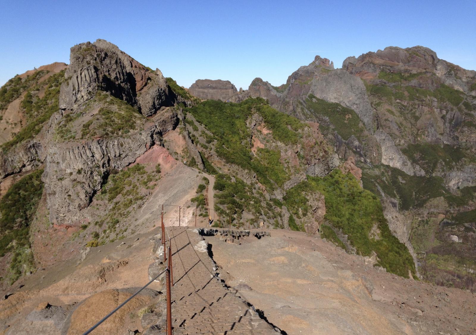
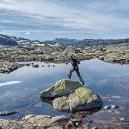
[PT] Madeira 2020
Dieter_Z. und ein anderer reagierte auf sja für Thema
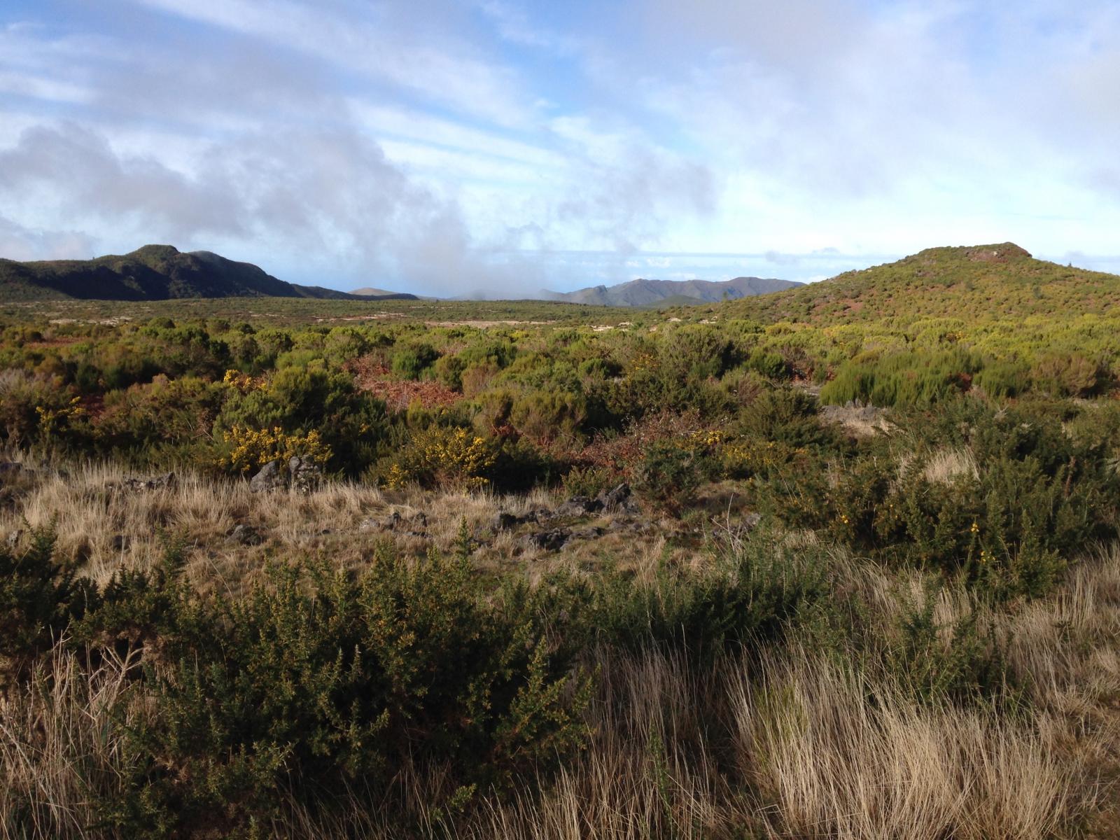
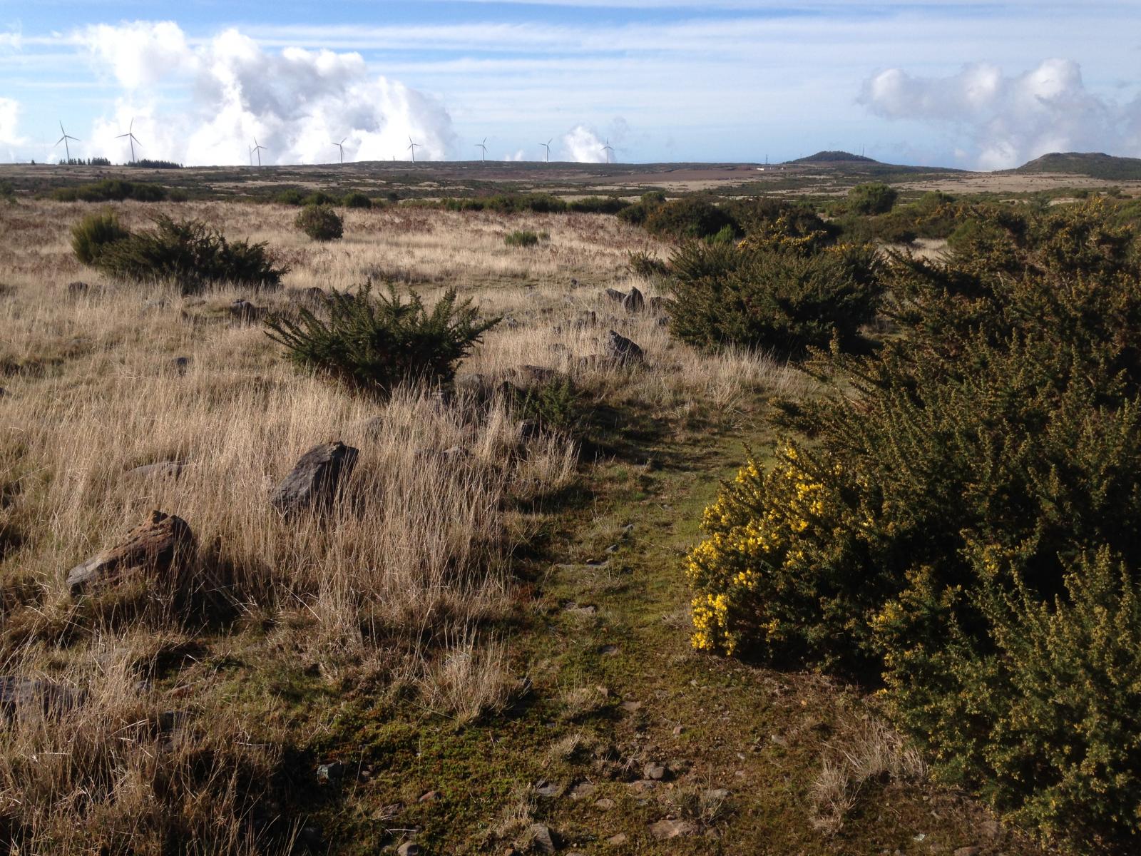
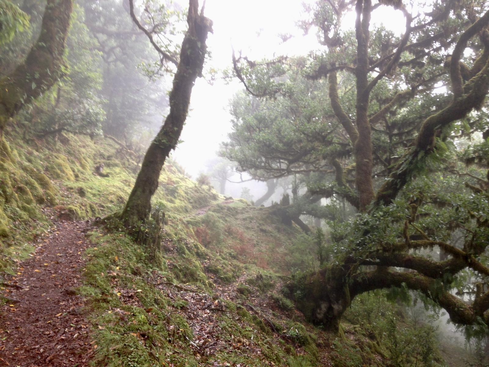
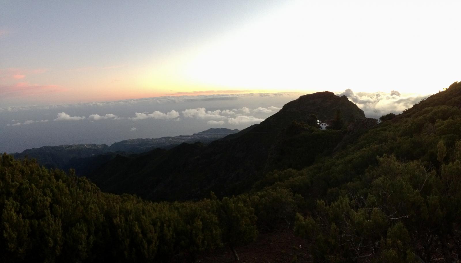
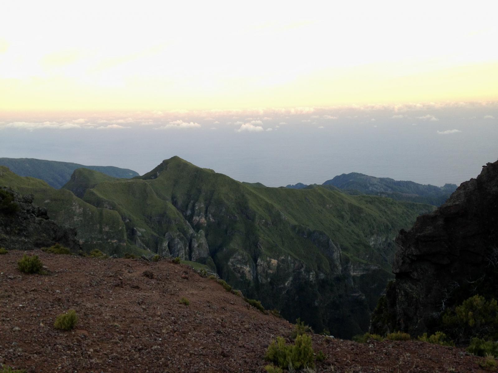
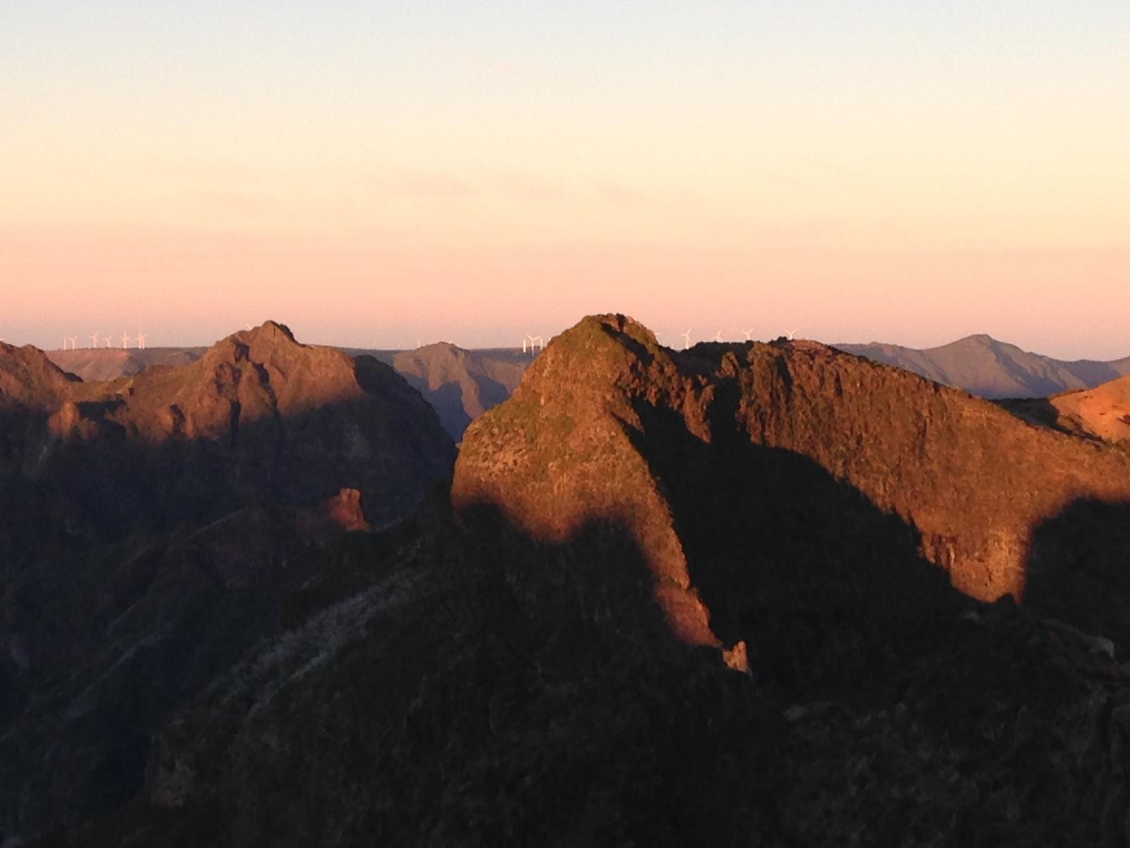
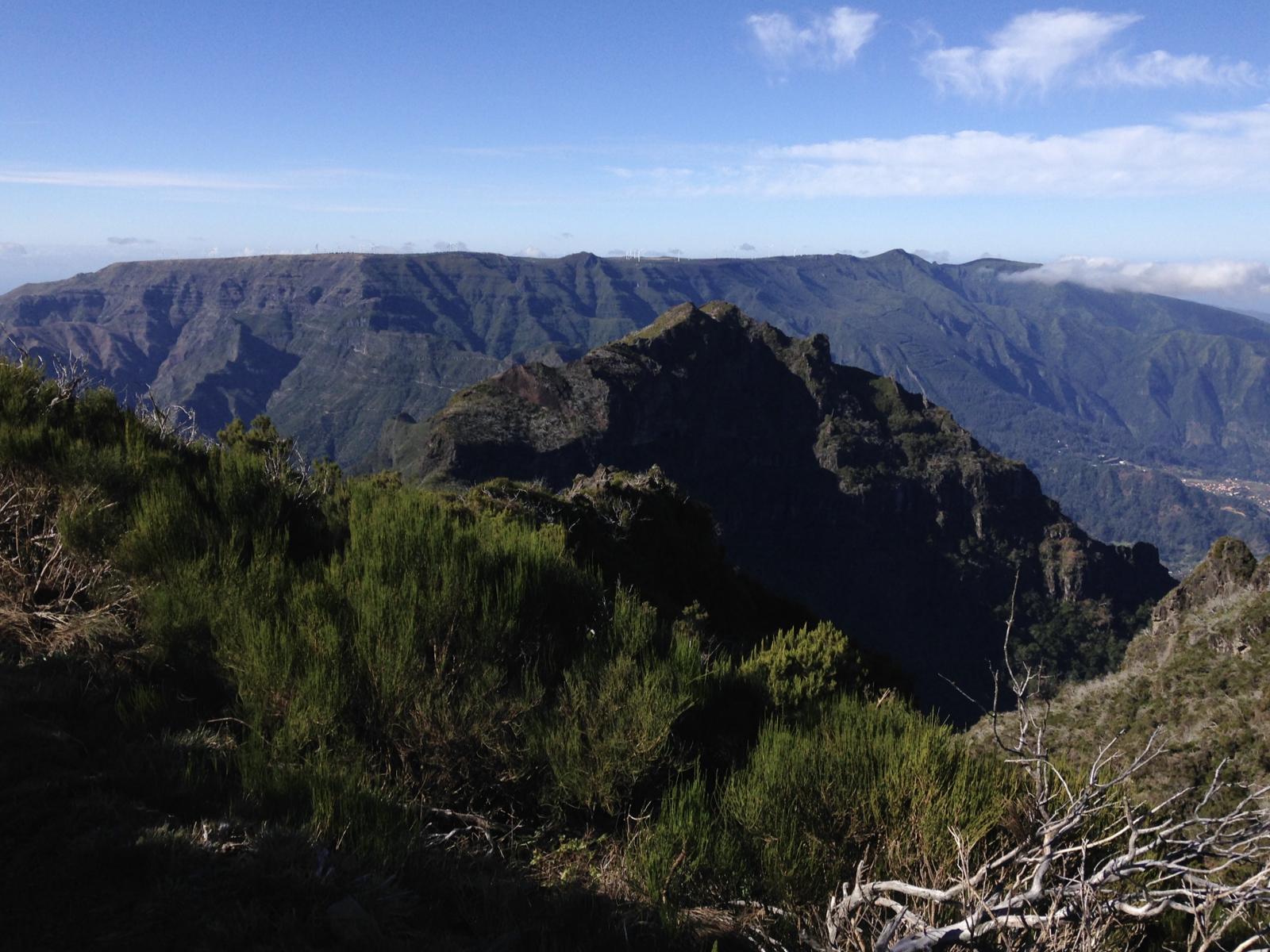
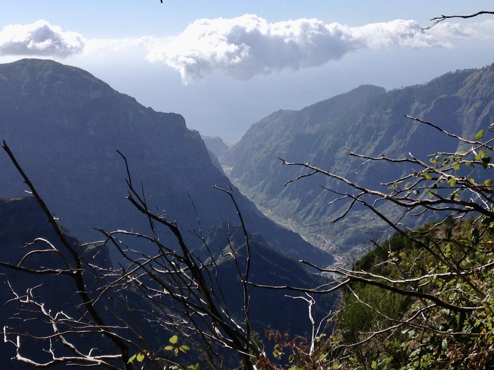
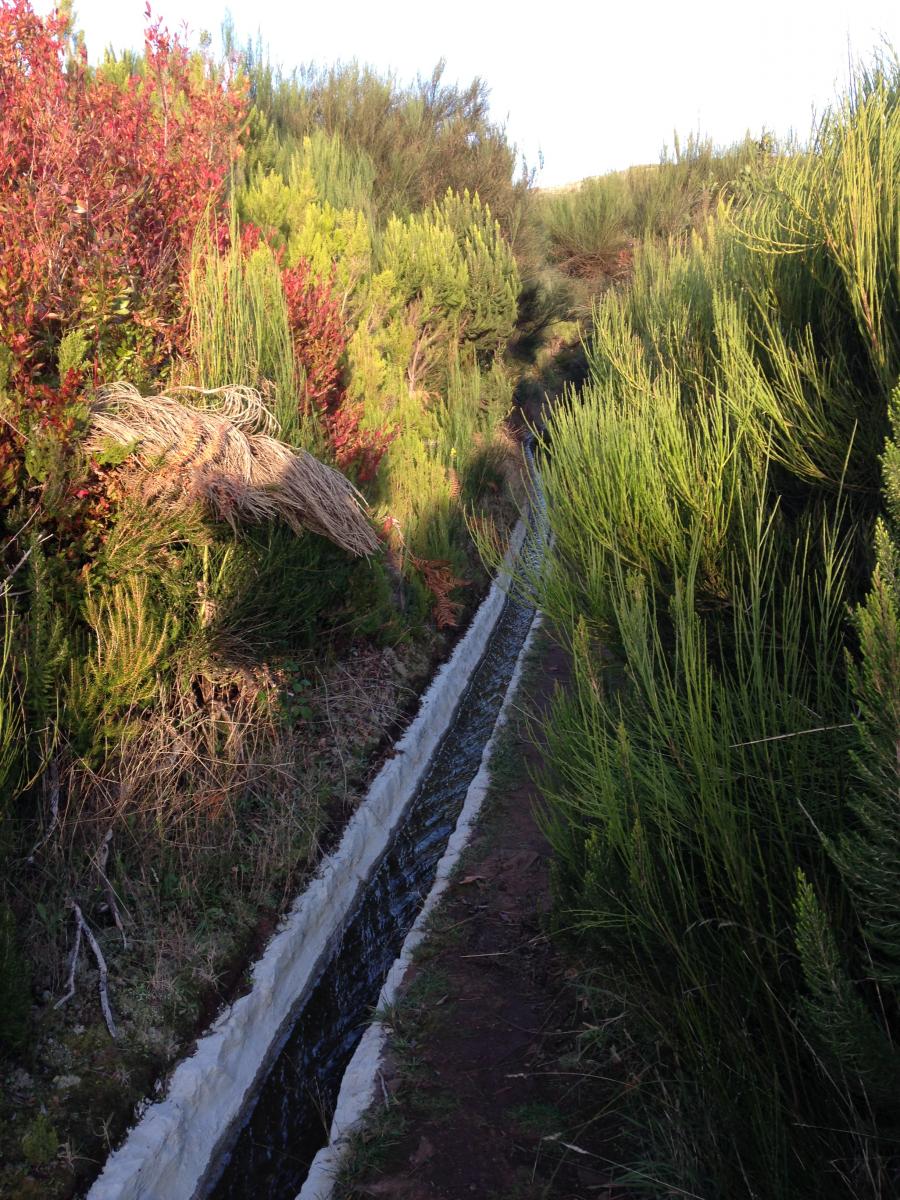
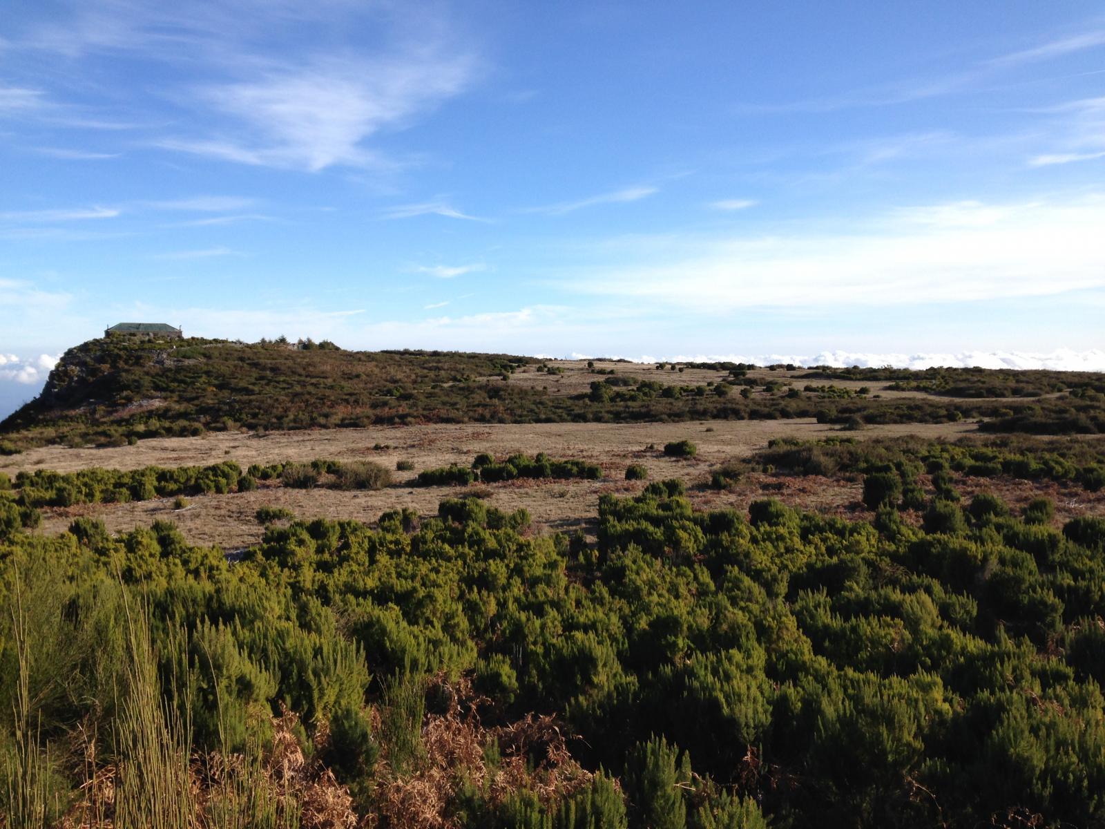
Tag 6: Nach Fanal Die abschüssige Regennacht hab ich irgendwie hingekriegt, will aber gar nicht aufstehen heute, also komme ich erst etwas später los. Sobald ich los laufe freue ich mich aber – so ist es eigentlich an jedem Morgen, wieder unterwegs zu sein. Heute habe ich nur ne kurze Etappe, denke ich – diese verlängert sich aber gleich mal wieder um ne halbe Stunde, weil ich im morgendlichen Tran einfach dem schönen Weg über die Hochebene folge und mich treiben lasse, immer der Nase nach. Die Abzweigung, ein ganz schmaler Pfad zwischen den Büschen hab ich nicht wahrgenommen. Ach, bevor ich s vergesse... 5 min nachdem ich gestern Abend in den Wald abgebogen bin, auf der Suche nach einem besseren Zeltplatz, kam eine weitere Picknick Area, die einen guten Übernachtungsplatz geboten hätte. Oh Manno... Es geht wunderschön über die Hochebene mit ihren unterschiedliche Heidepflanzen und Gräser, wenn die Sonne rauskommt, erscheint alles wieder in einem anderen Farbspiel. Ich muss hin und wieder ganz schön den Weg durch die Macchia suchen, zum Teil weglos. Später im Wald ich steh ich nochmal im Gestrüpp, will schon umkehren und die Straße nehmen, da seh ich den Weg dann doch noch. Nach Fanal. Wie in verschiedenen Beschreibungen gelesen, liegt es meistens im Nebel, so auch heute. Auch, dass es hier häufig sehr windig ist, bestätigt sich. Die alte Stinkorbeerbäume machen sich zwar gut in dieser nebligen, mystischen Stimmung, aber ich hätte auch nichts dagegen, wenn es etwas heller am Himmel wäre. Frau Antje (wie ich sie jetzt mal liebevoll nennen will), ist sicher noch ne Stunde weitergelaufen und sucht sich was Gemütlicheres..., für mich zu spät. Durch meine Trödelei am Morgen (es war fast 10 als ich los bin) und die Extrakilometer, ist es schon 16h, als ich in Fanal ankomme. Überlege lange, wo es am windgeschütztesten ist. Das parkähnlich Gelände ist terassenartig strukturiert. Auf oberster Ebene steht das Forsthaus, dort gibt es eine Ecke mit Hauswand und Hecke, hier könnte es windgeschützt sein? Wobei die Böen kommen aus unterschiedlichen Richtungen. Ist es weiter unten kälter oder wärmer? Warme Luft steigt nach oben? Aber die Bäume geben besseren Windschutz? Oh je. Sehe noch 2 Ausflügler, die mich etwas beäugen, ich warte lieber, bis sie weg sind. Versuche dann, mein Zelt neben dem Forsthaus aufzubauen. Der Boden ist bockelhart und beim Aufbauversuch fliegt erst die Tyvekplane weg. Als mir eine Sekunde später das Zelt (die Heringe waren noch nicht richtig verankert), halb um die Ohren fliegt, versuche ich Tyvek, Zelt und Rucksack unter den Arm zu krallen und die Böschung eine Etage tiefer hinunterzugehen zu den Bäumen… Der Rucksack rutscht mir aus dem Arm und findet selbständig den Weg nach unten. Glücklicherweise ist er halbwegs verschlossen. Und glücklicherweise beobachtet niemand das Spektakel. Unten kriege ich die Heringe wenigstens sehr viel besser in die Erde. Zack, zack muss es gehen, bevor die nächste Böe kommt. Erst denke ich, sieht sogar besser aus als die letzten Tage, das relativiert sich später jedoch... Koche mir noch schnell was und schreib ein wenig. Draußen tobt es und dicken, schweren Tropfen fallen auf die Zeltwand. Keine Ahnung ob es regnet oder es nur der Baum ist, vermutlich eher Letzteres. Es klingt jedoch alles recht bedrohlich. Die Böen drücken die Zeltwand nach innen, Gottseidank kommt das nicht soo häufig vor. Bemerke, in der Hektik und durch den Wechsel des Platzes habe ich den falschen Stock genommen, d.h. nicht den, mit der richtig eingestellten Höhe. Naja ist nicht soo viel. Krieg ihn noch etwas verstellt, aber will jetzt auch nicht zu viel Gewalt anwenden. Wird schon gehen. Wenn ich die Lampe anmache, kann ich die Wassertröpfchen in der Luft sehen, so dick ist der Nebel.
2 Punkte -

Interessante Tarpkonfigurationen
wilbo reagierte auf Christian Wagner für Thema
Bin neulich auf ein Video gestoßen in dem fünf, IMHO recht interessante und für mich neue Konfigurationen für ein 3x3m Tarp vorgestellt wurden. Allesamt Pyramidenzeltkonfigurationen, alle rundum geschlossen, fast alle mit Sitzhöhe. Auf dem Channel hat Papa Hiker noch einige interessante Videos zum Thema. Wer noch mehr (nützliche) Tarpkonfigurationen abseits von Lean- To, A- frame und Diamond pitch kennt, immer her damit.1 Punkt -
Wieso Comfort verzicht
martinfarrent reagierte auf dennisdraussen für Thema
Naja Verzicht ist hart, von Neoair xlite Reg zur Uberlite Large1 Punkt -

Wieso Comfort verzicht
martinfarrent reagierte auf khyal für Thema
Warum nicht, ich fand hier gewisse Diskussionen, bei denen Cast seine UL-Kletter-Rucksack 25 kg Theorien vertreten hat, immer recht vielseitig Da sehe ich aber aufgrund der Material-Entwicklung auch gewisse Unterschiede zu frueher... Vor einigen Jahrzenten, als das leichteste 1P-Zelt, was ich hatte, ca 2 kg wog, hat es gewichtsmaessig richtig viel gebracht, statt dessen mit Tarp und Haengematte unterwegs zu sein. Heutzutage wo es sturmfeste 1 P Zelte, die 430 g und 2P Zelte die 530 g wiegen, gibt und mein leichtestes 2P Zelt 600g wiegt, hat sich das fuer mich ein bisschen relativiert.1 Punkt -
Wieso Comfort verzicht
martinfarrent reagierte auf ULgäuer für Thema
Und damit habe ich ja auch recht. Mir geht es um den Begriff "verzichten". Mitnichten verzichten! Besser gewichten. Der Bereich der optimalen Gewichtung hängt dann halt stark von den Umständen ab. Bei einem Overnighter mit 15km Anmarsch kann man wohl mal die Gefahr von Belastungsbrüchen ignorieren und ein extra Snickers mitnehmen. Für den Luxus. Dass man solche Eskapaden dann aber nicht auf Lighterpack in die Welt posaunt, versteht sich aber, hoffe ich.1 Punkt -
Der „Kurze Frage, kurze Antwort“-Thread
Andreas K. reagierte auf dennisdraussen für Thema
OT: Nein ich bespasse ehrenamtlich Kinder im Sportverein, Grizzlys hätten Angst vor denen. Damit die Gurkentruppe Spaß hat investiere ich halt Zeit und Nerven. Und ich kann zu „ich bin ein Gummibär“ tanzen. Das Lied gibts auf YouTube, fiese Challenge...1 Punkt -
OT: Gut, dass es die Pagode noch gibt - meine alten ali-favoriteneinträge funktionieren nämlich alle nicht mehr...1 Punkt
-
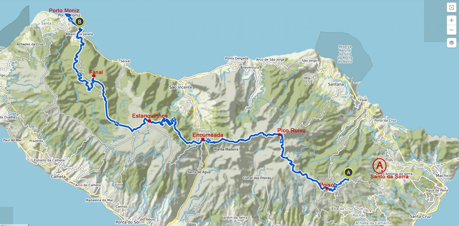
@alle - hab mich gefreut, dass so viele mitgelesen haben danke für das nette Feedback. @fool Viel Spass, es wird sicher toll: Wenn du Camps "buchen" willst, am Besten alle auf einmal - irgendwie ist die Site buggy und es "verschwinden" gern mal einzelne Camps in dem Select während der Auswahl. Oder nochmal mit nem anderen Browser probieren. Solltest du in Funchal ne Nacht bleiben wollen - ich hab in der Pension Pensao Residencial Mirasol übernachtet. Ist eine Straße oberhalb der Altstadt gelegen, nah zur Bushaltestelle. Ist zwar etwas schrabbelig, kost aber auch nur 33 Euro ohne Frühstück und hat Charme. Die Betreiber sind super nett gewesen. Außerdem kann ich das Café Barreirinha Bar Café empfehlen, östlich der Kirche in der Altstadt (also noch etwas östlicher der - wie ich finde - etwas nervigen "Restaurant-Meile"). War ein nettes Publikum, man kann superschön zum Sonnenuntergang hin , weil direkt oberhalb vom Meer. Viele sitzen auch lässig auf dem Mäuerchen... @roli Ich bin im Prinzip die "gemachte Tour von Taeve-Supertramp" gegangen. Ich glaube ab und zu ist er die Straße gegangen, wo ich den Waldweg nahm. Hatte mich eher an einzelne Tracks von @ChristianB (danke nochmal) gehalten (hab selbst nicht aufgezeichnet). Aber zur Orientierung (bei Santo da Serra gestartet): Glaub du bist über Rabacal gegangen? Dort war ich nicht.
1 Punkt
-
Danke für den Bericht! Welchen Weg bis Du eigentlich gegangen bzw. hast Du einen GPS Track. Scheinbar war mein Weg zum Großteil ein anderer1 Punkt
-
Hey sja, danke dir für den tollen Reisebericht - hat viel Spaß gemacht zu lesen! Und natürlich die Bilder zu gucken... Bei mir gehts in 3 Wochen ebenfalls nach Madeira - bin schon ganz gespannt, wie es mir so ergehen wird. Liebe Grüße fool1 Punkt
-

Der „Kurze Frage, kurze Antwort“-Thread
dennisdraussen reagierte auf mawi für Thema
Die Antwort von Cascade Designs:1 Punkt -
Ich glaube die Aeropress Go (kleinere Version der Aeropress, die in viele Tassen / Toepfe passt) hatten wir noch nicht... Gibt es auch schon bei einem vernuenftigen Shop in D...1 Punkt
-
Der „Kurze Frage, kurze Antwort“-Thread
schrenz reagierte auf Andreas K. für Thema
OT: nähen ist nur was für echte Männer!1 Punkt -
Waschmittel für Wolle gesucht
Schwefelfell reagierte auf AlphaRay für Thema
Wieso sollte das nicht schonend sein? Ist an sich "normal" bzw. schadet der Wolle normalerweise nicht. Essig nutzt man übrigens um eingelaufene Wolle wieder "weicher" zu bekommen (entspannt die Fasern) um sie Strecken zu können Erfolgreich bei einer guuut eingelaufenen Wolldecke ausprobiert Am WE habe ich frischen Lodenstoff in der Maschine gewaschen. Dieser ist gar nicht eingelaufen - ist aber auch ein von sich aus dichter Stoff. Hier allerdings auch nur bei 30° (höhere Temperatur + mehr Seife = stärkere Verfilzung = stärkeres Einlaufen) und 400 upm Schleudern. Stinknormales Eco-Waschmittel aus der Drogerie genutzt.1 Punkt -
Der „Kurze Frage, kurze Antwort“-Thread
einar46 reagierte auf dennisdraussen für Thema
Ich hab die Overlock gekauft meine Frau muss nähen, DIY vs SKDB (SIE KANN DAS BESSER)... ich hab den von extex mal bestellt, wir werden sehen. danke!1 Punkt -

Waschmittel für Wolle gesucht
Schwefelfell reagierte auf Jens für Thema
Man könnte den/die abgetrennten Zettel ja auch mit Tesafilm an die Innentür des Kleiderschranks kleben...1 Punkt -
Interessante Tarpkonfigurationen
wilbo reagierte auf Christian Wagner für Thema
Mal was für bikepacker...1 Punkt -

Wintermatte
Painhunter reagierte auf cico für Thema
Du könntest eine Evazoten mit einer Luftmatte kombinieren, z.B. relativ dicke Eva mit der Uberlite oder xlite1 Punkt -
Tag 5: zur Hochebene Paul da Serra Gönne mir heute morgen ein richtiges Frühstück mit Kaffee und warmem Porridge. Als ich um 8h packe, kommen 2 Autos mit portugiesischen Familien an. Barbecue wird vorbereitet: Hey Leute. Ihr seid 3h zu früh, es ist SONNTAG! NEBLIG. Scheint keine Rolle zu spielen. Es folgt die klassischer Rollenverteilung: Männer fällen einen Baum (naja nicht ganz) und machen Feuer... Ich verzieh mich schleunigst. Erst gehts nochmal zurück zum Boca da Encumeada. Bevor es zur Levada PR17 geht, nochmal einen Blick zurück. Der Weg an der Levada entlang ist recht entspannt. Ich hatte die Tage schon mal einen Tunnel aber dieser hier ist richtig lang und finster, die Felswände erzwingen ein gebücktes Gehen. Gegenverkehr sollte es keinen geben, sonst muss man sich einigen, wer zurück geht. Am Ende, außerhalb des Tunnels stürzt das Wasser eines kleinen Wasserfalls in die Levada. Tierisch laut. Etwas später muss ich in einen kleinen, wunderschönen Wald absteigen und das gefühlt 10fache an Höhenmetern in Form einer nicht enden wollenden "Treppe" wieder hoch. Es Schmerzen die Muskeln, aber irgendwann ist man ja immer oben (!) Wieder eine Zeitlang eben. Wunderschöne Vegetation. Fast schon dschungelartig. Ich versuche etwas Tempo zu machen, um meine Schwäche am Berg aufzuholen. Würde heut gern nicht so spät ankommen. Es geht nochmal durch einen weiteren beeindruckenden Wald, die Bäume sind mit allerlei Flechten bewachsen. Dann der letzte Anstieg, auch hier komme ich hoch. Zuerst das Camp eruieren, etwas abschüssig, ein Barbeque-Platz mit Tischen und Bänken, wie bisher auch. Ich recherchiere im Netz, ob ich was übersehen hab, ich meine es gibt zwei... da höre ich es rascheln und die Frau mit dem Ospreys-Rucksack (eine Holländerin), der ich schon 2mal begegnet bin, tritt aus dem Camp. Diesmal lachen und sprechen wir (mehr als Hallo). Sie findet das Camp auch etwas zelterunfreundlich bzgl. der leichten Hanglage und mag lieber etwas versteckter stehen. Sie scheint, im Gegensatz zu mir, Erfahrung zu haben und hat sich selbst auf dem Pico Ruivo (bzw. ein Stück danach) ein eigenes Plätzchen gesucht, seufz. Tja... aber diesmal versuche ich es auch. Warte, bis sie ihre Ganrzkörperwäsche beendet hat (ich bin da sparsamer), fülle mir Wasser ab, verabschiede mich (bis Porto Moniz haben wir dieselbe Strecke) und marschiere los. Heut hab ich noch etwas Energie. Geh ca. 15 min weiter und biege einmal nach rechts und wenig später nach links in einen Wald Richtung Levada ab. Aber richtig überzeugt mich nichts. Es fängt an leicht zu nieseln. Also gehe ich lieber wieder zurück. Schaue nochmal hinterm Camp etwas versteckter und siehe da, im Wäldchen gibt es eine Stelle, die könnte gehen, noch mit Blick auf die Hochebene. So richtig werde ich die Landschaft hier erst morgen wahrnehmen können (es nebelt auch schon wieder). Als das Zelt steht (mittlerweile regnet es leicht), und ich nach einer Polenta mein Schlafplatz im Innern einrichte, merke ich, ach du sch.... ich rolle wieder längsseitig zum Eingang. Das nervt tierisch. Versuche was unter die Matte zu legen. Hilft alles nix. Hoffe nur, dass nicht zu viel Zug an der Zeltwände ist. Zeltplatz-Auswahl will gelernt sein. Hm. Und zu guter Letz höre ich ein feines Motorengeräusch von Ferne. Die Windräder? Kommt mir aber vor als wäre es die andere Richtung... Ist aber nicht so schlimm und irgendwann höre ich es auch nicht mehr. Wo die Holländerin jetzt wohl ist?
1 Punkt
-
Tag 4: Encumeada Naja, dass die Nacht nicht kuscheliger würde als gestern, war ja abzusehen. Immerhin bin ich auf 1800 m. Aber will jetzt mal nicht wieder so ein Drama machen und kürze das Ganze ab… Der „vento“ kam, aber (zumindest die meiste Zeit), aus der richtigen Richtung und ich lerne, dass man den Quilt oben zuclippen kann, ach wie praktisch. (In meiner Jugend auf Campingplätzen am Mittelmehr hab ich mich immer gewundert, ob man das Gestrippe und Gezuppel am Schlafsack wohl jemals mal braucht…). Und von der xlite Neoair Woman war ich ja bereits schon vor Madeira Fan, angesichts der Wärme von unten und des Wohlfühl-Faktors. Um 2h gehts mal vor die Tür und ich sehe einen unglaublichen Sternenhimmel wow - Zum Sonnenaufgang geht s dann weiter. Ein paar Fotos, aber auf den Peak schaffe ich es nicht mehr, nur noch ein Blick auf das Berghäuschen: Meine Mukkis sind wie Pudding - anfangs ist es immer noch… sagen wir mal frisch, aber wenn man sich bewegt, geht's. Der Weg verspricht heute wieder wunderschön zu werden, meine Beine sind aber noch ordentlich zittrig. Zwänge mir noch nen Riegel rein, viel gefrühstückt habe ich nicht. Sobald etwas geschützt und tiefer, setze ich mich aber auf eine Steinstufe und packe meinen tollen Stormin aus – ruckibzucki steht ein heißes Käffchen vor mir. Ach wie toll. Brauch noch etwas Anschub, bin definitiv zu fahrig. Der Kamm gefällt mir fast noch besser als gestern. Immer wieder tolle Blicke zu beiden Seiten. Ich müsste eigentlich alleine sein, da vom Ruivo niemand startet, denke ich... - umso mehr erschrecke ich, als von hinten ein Typ mit Rucksack - Handtuch hängt raus - im Stechschritt vorbei marschiert. Ich wundere mich, was für ein Tempo, kurzer Smalltalk wär auch nett gewesen, der is bestimmt auch mit Zelt unterwegs. Hat der am Berghaus gezeltet? - well, muss auch nicht. Den Smalltalk habe ich 1h später mit einem reizenden, englischen Pärchen, nennen wir sie mal Linda und Colin: How do you do? Ich war so verdattert, aber umso erfreuter über die freundliche Ansprache. Mittlerweile kommen mir ein paar Tageswanderer von Encumeada entgegen, die aber auf halber Strecke nach Corral das Freiras ins Nonnental absteigen. Um 15h komme ich am Restaurant am Encumeada an, es brutzelte tatsächlich den ganzen Tag die Sonne, so dass ich mich sogar für den Café in die Stube setze. Welch ein Kontrast. Nachts wenige Grade über 0? (schätze ich, denn es gab auf den Pfaden zu Anfang kleine leicht vereiste Stellen), tagsüber 25? Also weiter unten. Bin wieder auf knapp 1000m. Will mich aber mit Nichten beschweren... Habe den ganzen Tag überlegt, ob ich mich in dem Hotel eine halbe Stunde südlich für die Nacht einmiete, irgendwie wär mir danach… aber es ist eh nix frei; gut so. Also auf zum Camp: 20min down. Liegt wieder recht nah an einer wieder kaum befahrenen Straße. Finde ein halbwegs geschütztes Plätzchen hinter einem Baum und hab mental nen kleinen Hänger – trotz der superschönen Etappe. Pause. Bett, Dusche, ein Abend in netter Gesellschaft.... geistert mir im Kopf rum. O.k. erst mal Pasta kochen. Hat schon manchen trüben Gedanken vertrieben. Gehirn braucht jetzt Kohlenhydrate. Nach dem Essen kommt mir mein einziger Teebeutel zwischen die Finger. Boah... coole Sache! Erstaunlicherweise hab ich da grad voll Lust drauf. Spiritus hab ich genug. Freu mich also irre über den bevorstehenden Tee - als ich dann auch noch lese, was drauf steht, muss plötzlich innerlich so lachen: BREEEATHE DEEP... so schnell kanns gehen, alles wieder gut. Gönne mir zudem heut auch etwas mehr Strom für s Handy, Solarpanel hat heute getan, was es soll. Für Porto Moniz plane ich dann aber trotzdem nen day off.
1 Punkt
-
Tag 3: Das Rückgrat der Insel - Pico Arieiro - Pico Ruivo 7° feels like 5 sagt YR - feels like ... weniger ... denke ich... Heute gehts hoch Zum Pico Arieiro (1818 m) und von da zum Pico Ruivo (1862 m), eine vielversprechende Etappe. Kurz nach Sonnenaufgang gehts los. Die Nacht entwickelte sich zum Eisschrank. Erst ging es noch und ich ziehe meine kuschelige Daunenjacke zum Schlafen AUS. Man muss ja nicht gleich mit Spatzen auf... wie sagt man? Um 4 Uhr, nach einer kurzen Nacht (konnte partout nicht einschlafen), wache ich fröstelnd? frierend? auf. Also zusätzlich Daune und irgendwann auch Windhose über die Leggings, dann isses wieder ok. Seltsam, habe doch schon mein Fleece an und einen 450er Cumulus Quilt, eigentlich sollte er bis -1 Grad gut sein…, hatte damit auch schon bei ähnlichen Temperaturen genächtigt.. aber nun… Start klappt gut, Sonne lacht und die morgendliche Stimmung und das Licht verheißen einen schönen Tag. Der Anstieg zum Arieiro zieht sich etwas. Oben eisiger Wind. Ausflugslokal: schlechter Kuchen, unfreundliche Bedienung aber etwas Strom fürs Handy. Lange nicht mehr lauwarmen Cappuccino mit Sahnehaube serviert bekommen.. bäh. Der Weg über den Steig zum Pico Ruivo ist beeindruckend und geht über viele, viele Treppen. Man kann heute deutlich erahnen, dass die Insel vulkanischen Ursprungs ist. Was für ein Glück mit dem Wetter, strahlender Sonnenschein und Sicht bis auf die Hochebene. Ich weiß nicht, wie oft ich im November das Wetter dort oben mit meiner App gecheckt hatte und immer war Regen angesagt. Niemals hätte ich mit blauem Himmel gerechnet. Natürlich bin ich hier nicht die einzige auf dem Weg, aber bei der Aussicht auch kein Wunder. Auf dem Ruivo angekommen, setze ich mich noch kurz vor das inzwischen wieder offene Berghaus (Es gibt hier Getränke und Schockoriegel). Ich bin ziemlich geschafft. Frage die Bedienung nach dem Camp. Sie spricht kaum englisch und zeigt mir nur die zwei „Steinhäuschen“. Hm, hab kein freistehendes Zelt, wüsste nicht wie ich mein Zelt auf Beton zum stehen kriegen soll. Sie weiß anscheinend nichts anders, vermittelt mir jedoch, dass ich links und Rechts vom Berghaus nicht zelten könnte (wo ich aber eh nur abschüssiges Gelände sehe, oder meint sie was anderes?): „vento, vento“, was ich jetzt mal mit Wind übersetze. Meine Karte weiß, wo die zwei kleinen Stellplätze sind. Noch ein paar Meter Richtung Encumeada. Nehme den zugemüllteren der beiden Plätze weil sichtgeschützter und keine Lust auf Beobachter vom Pico (obwohl es bald dunkel wird, gibt es noch ein paar Leute, die da rumturnen und sich bemerkbar machen…). So richtig prickelnd ist es nicht, mit den vielen Taschentüchern im Gebüsch, aber bin zu müde, um weiterzulaufen. So what, gucke einfache in die andere Richtung und alles gut. Während des Essens hält sich die Außentemperatur noch einigermaßen, dann zieht Nebel auf, schaue mir noch kurz die Lichtstimmung bei Sonnenuntergang an, aber bald muss ich unter die Daune.
1 Punkt
-
Tag 2 Von Santo da Serra nach Poiso Mit dem Bus geht es heute morgen nach Santo da Serra, weit im Osten der Insel. Neujahr gab es am Nachmittag so wenig Busse, daher die Nacht in Funchal. Den „alcohol etilico“ für den Brenner kaufe ich zuvor im Supermarkt, praktischerweise in der 250ml Flasche. Der Rucksack mit dem ganzen Futter trägt sich ganz ok. Hab mir aber auch unglaublich Mühe gegeben, meine Nahrungsaufnahme zu optimieren. Zwei Tage zuvor stand ich von morgens bis Abends in der Küche und habe meine liebsten Müsliriegel zubereitet, Knäckebrot nur aus Nüssen hergestellt, Porridge gemischt, Gemüse getrocknet und Couscous, Polenta & Co vorbereitet – und natürlich Kalorien gerechnet. Verhungerungsängste nennt man das wohl… Und zur Not gibts dann ja noch geröstete Mandeln und Datteln zwischendurch. Als ich am Kreisverkehr bei Santo da Serra ankomme, wird das Wetter immer schöner. Ich gehe los, bin so happy und enthusiastisch dass es endlich los geht und dass ich aus der Stadt raus bin. Nach kurzer Zeit erreiche ich schon die Öko(?)Forellenzucht / den Forellenpark von Paulo ("Parque Ribeira Primeira"), die ich bei der Vorbereitung der Wanderung entdeckt hatte. Hm, jetzt schon? Ich kann aber einfach nicht anders und muss hier was probieren, easy heute, außerdem… man weiß ja nie… was man im Bauch hat…, der Kocher könnte ja versagen, der Spiritus auslaufen oder mein Couscous unterwegs aus dem Rucksack rieseln… haha… Das Lunch besteht also aus einer unglaublich leckeren gegrillte Forelle, Kartoffeln, Salat und ein Humpen Wein ist inklusive. Außer mir ist nur ein englisches Pärchen da. Ich laufe nach dem Humpen natürlich ziemlich beschwingt weiter. Leider ist es jetzt schon 12:45 h und ich muss mich etwas ranhalten. Bald schon erreiche ich meine erste Levada namens Levada da Serra. Ich laufe ein Stück entlang, dann geht es aber bergauf Richtung Pico do Suna. Von da sehe ich auch zum ersten Mal in der Ferne die Radarstation (weiße Kugel) oben auf dem Pico Arieiro. Mein Plan ist, bis Poiso zu laufen, zwar liegt das Camp recht nah an der Straße, aber ich will vermeiden, dass der nächste Tag länger wird als muss - es stehen echt viele HM an. Der Weg vom Camp Terreios zum Camp Poiso ist nicht wirklich der Knüller, aber egal, gut dass ich die Strecke heute schon gehe. Ich hole mir Wasser im Ausflugs-Restaurant, auf dem Weg zum Camp Poiso und will schnell mein Zelt aufbauen. Allerdings - das Camp ist doch irgendwie doll an der Autostrasse und man – ich – stehe mit meinem Lunar da ganz schön auf dem Präsentierteller. Außer mir zeltet hier keiner. Sicher, wenn es dunkel wird, fahren hier bestimmt nicht mehr viele Autos, wenn überhaupt und das Zelt wird dann sicher auch kaum zu sehen sein. Überlege trotzdem weiter zum nächsten Camp auf der Hochebene Feiteiras de Baixo zu laufen. Ich gehe auf der anderen Straßenseite in den Wald und folge dem Pfad ein Stück, da sehe ich ein kleines ebenes Fleckchen mit Gras bewachsen und denke, das müsste doch passen, schön geschützt. Ich hadere trotzdem noch etwas, ob ich noch weiter gehen soll, aber hey, ist doch alles gut hier. Baue schnell mein Zelt auf und nutze zum ersten mal so richtig mein Stormin Stove System. Bin ziemlich begeistert. Funktioniert prima, steht stabil, ist fix, gut geschützt… Das erste Essen kochen unterwegs hat geklappt - HOORAY! Und ich freue mich auch, dass ich so ein schönes Plätzchen gefunden habe und nicht auf dem Camp geblieben bin. YUHUH! ‚Es wird schnell recht kühl um nicht zu sagen kalt…, morgen wird es sicher noch kühler, auf den 1800 m, schluck… Aber erst mal sehen, wie DIESE Nacht hier wird…
1 Punkt
-
Tag 1 Anreise Drama. Natürlich in der Nacht vor Nervosität kein Auge zugemacht. Um Mitternacht ein paar Neujahrsgrüsse verschickt, um halb 3 Richtung Airport aufgebrochen. Als ich die Wohnungstür abschließen will, merke ich, dass mein ach so ultraleichter Schlüsselbund den Wohnungsschlüssel nicht mehr enthält. Statt des Wohnungsschlüssels nehme ich jetzt den Büroschlüssel mit, na spitze. Zum 100. Mal nehme ich mir vor, den Ersatzschlüssel bei Freunden zu deponieren... SMS an J. für Notunterkunft in die Nacht, wenn wenn ich zurückkomme. Nächstes Problem: U-Bahn fährt unregelmäßig - klar New Year's Eve..., RTW-Einsatz, was sonst…ich warte... die Anzeige sagt mir "unbestimmte Verspätung"…, dann folgt eine Entscheidung für ein Taxi, zumindest erstmal in Gedanken. Ich gehe aus der U-Bahn-Station, um vorsichtig die Lage checken. Das erste Glück im neuen Jahr, siehe da, es fährt das gewünschte Auto vor und ich behaupte mich großartig gegen 4 Jungs, die in dieser Nacht schon gewaltig Spaß hatten. Ihre Strategie, 3x soviel Kohle für die Fahrt zu bieten trifft bei meinem super-netten Taxifahrer glücklicherweise auf Empörung. Es handelt sich um einen fröhlichen IT-Ingenieur, der zum Spass (?) in seinem Urlaub (!) in der Silvesternacht ne Tour macht - wie er sagt handele es sich um geschenktes Geld (?). There we are. Sicherheitskontrolle: Kleine Schrecksekunde, als ich meinen Rucksack öffnen soll. Die wollen doch nicht etwa meine Trekking-Stöcke beanstanden? Oder meinen nigelnagelneuen Stormin Stove? Die 3kg Proviant? Alles easy, nix auspacken. Der Kragen meines Rucksacks wird auf Sprengstoffspuren untersucht.... Habe keine Böller eingepackt, hihi. Funchal 14h - Flughafenbus in die Stadt gekriegt, check. 16:30h sitze ich in einem leicht schrabbeligen Stassencafe im schönsten Sonnenschein, check. Mir fallen ständig die Augen zu, nicht check. Um mich rum ein paar betagte Touristen. Ich überlege, ob die wohl von dem Hochhaus-Dampfer, auf den ich Richtung Süden blicke, kommen? Ich stelle mir vor, wie ich in den nächsten Tagen im Grünen bin und denke bei diesem bizarren Anblick namens „all inklusive“, wie unterschiedlich die Bedürfnisse sind. Ich laufe noch etwas durch die Stadt und werde auf beeindruckende Weise von einem älteren Herren daran erinnert, dass Training gar nicht so ne schlechte Idee ist…:
1 Punkt
-
Es fehlt noch "The free sprits"... Das Libra2: https://de.aliexpress.com/item/1000007928122.html TStargazer: https://de.aliexpress.com/item/4000215552171.html ... und die Zelte von Knot. KB020 "Pagode" https://de.aliexpress.com/item/4000022218877.html "KA0201" Name unbekannt https://de.aliexpress.com/item/4000125164192.html "KB060" Name unbekannt https://de.aliexpress.com/item/33002536641.html "KD010" Name unbekannt https://de.aliexpress.com/item/33001781887.html VG. -wilbo-1 Punkt
-
Vom 22. September bis zum 11. Oktober 2019 wanderte ich vom Kibbuz Dan im Norden Israels bis nach Arad, dem letzten Ort vor der Wüste im Süden Israels. Insgesamt wanderte ich über sechshundert Kilometer durch Israel. Meine Art zu Wandern würde ich immer noch als Fast & Light bezeichnen - für Israel um diese Jahreszeit eher mässig gut geeignet. Nachfolgend meine „Learnings“: Vorfeld Ich unternahm wenig Recherche, und stützte mich auch auf die Seite von Christian Seebauer. Er bezeichnet den INT als Alternative zum Jakobsweg. Diese Seite idealisiert den INT in teilweise problematischer Weise. Er tischt keine Lügen auf, aber ein sehr ernstes Problem, auch für politisch überhaupt nicht interessierte, taucht auf seiner Seite nie auf. Das allergrösste Problem für Hiker: Müll. Wer sich entschliesst den INT zu wandern, muss sich bewusst sein, dass er täglich an Müllbergen vorbei und durch Müllhalden hindurch wandern wird. LNT ist in der Gegend leider unbekannt. Alle lassen ihren Müll einfach liegen. Unabhängig von Herkunft oder sozialer Schicht. Um Tel Aviv findet man Gu Beutelchen d.h. eher hochpreisige Spezialsportnahrung auf dem Trail (was anderswo völlig verpönt ist), rund um Landwirtschaftsbetriebe was dort halt so anfällt. Es fällt eben sehr viel an. Der INT ist leider IMHO ungefähr so sehr eine Alternative zum Jakobsweg wie Herr Trump zu Herr Obama. Alles wird in der Natur entsorgt. Autos, Ölkanister, Farbe, Aludosen sowieso. PET-Flaschen werden in Israel offenbar aus höchst demetrigem, biodynamischem Dünger hergestellt. Anders ist die Zahl dieser Flaschen in der Natur nicht erklärbar – weshalb kommt jemand auf die Idee, eine leere Flasche mit sich herumzuschleppen? In Europa ist ein sinnvollerer Umgang mit Plastik im Gespräch, in Israel pflegt man Plastik einfach in der Natur abzulegen. Israel ist ein Hightech-Land, namhafte Software-Hersteller haben hier Entwicklungszentren, in manchen Bereichen waren und sind sie weltweit führend. Genügend Mittel, um etwas gegen den Abfallwahnsinn zu tun, wären durchaus vorhanden oder liessen sich organisieren. Wer in Israel LNT praktiziert kommt sich vor wie ein Idiot. Würde der PCT irgendwo so aussehen wie der INT überall aussieht, auf dem PCT würde der Abschnitt umgehend geschlossen. Ranger oder das entsprechende Sheriffs-Department würden den Trail als Gefahr für die öffentliche Gesundheit einstufen. Volunteers würden den Trail in tagelanger Fronarbeit reinigen. Wie auf dem AT würde man den Trail anschliessend quasi überwachen (mittels Ridgerunners oder ähnlich). Das ist leider noch nicht alles. Aufgrund der Bodenbeschaffenheit ist ein wichtiges Element von amerikanischem LNT in Israel nicht umsetzbar. Ein sogenanntes Cathole zu graben, ist unmöglich, da der Boden entweder zu felsig oder Betonhart getrocknet ist. In Israel müsste man statt einem Schäufelchen eine Spitzhacke mitführen. In den USA werden diese Löcher vor allem gegraben, um das ästhetisch störende WC-Papier zum Verschwinden zu bringen. Was unternimmt mensch in Israel dagegen? Leider gar nichts. Beispiel: «Ein Kobi» Campingplatz, ein paar Stunden zu Fuss südlich von Jerusalem. Landschaftlich gesehen ein Traum, monatelange Planung eines toskanisch inspirierten Architekten brächte kein besseres Resultat. Teile der Anlage sind sogar historisch, es gibt eine Quelle. Der Platz wird offensichtlich von Gruppen genutzt. Die erste Ebene an der Strasse ist denn auch relativ sauber, es finden sich nur kleinere Gegenstände wie Kaffeebecher, Einweggeschirr und unzählige Haargummis am Boden. Die nächste Ebene gegen den Wald dient aber als gigantisches WC. Wie im Kuhstall, einfach für Menschen. Es riecht. Im Norden wiederum ist wirklich jedes Plätzchen entlang des Trails gründlichst eingeschissen. WC Papier mitzuführen halte ich grundsätzlich überall auf diesem Planeten für überflüssig. Es ist weder ultraorthodox LNT und vor allem noch nicht mal UL! In Israel und für Israel gibt es eine Organisation, die seit der Staatsgründung und zuvor Milliarden in die Aufforstung des Landes investiert hat. Der Israel National Funds hat ganze Wälder gepflanzt. Es wurden unzählige Picknick-Plätze angelegt (ja, es gibt mittlerweile zu viele), jeweils gestiftet von Personen aus aller Welt. Diese Orte dienen auch der Erinnerung an im Holocaust ermordete jüdische Personen oder an Personen, die durch ihr Wirken während der Nazi-Tyrannei Juden gerettet haben. Auch für gefallene israelische Soldaten gibt es Gedenkstätten. Und alle Plätze haben eines gemeinsam: Müll und Toilettenpapier überall (sogar bei den Gedenksteinen für Gefallene – ich bin auch nicht immer 100 % mit allem was so geschieht einverstanden, würde mich aber trotzdem aus Respekt niemals über oder neben einem solchen Stein erleichtern). Bei einem Stein für Simon Wiesenthal habe ich den Busch vornedran zurückgeschnitten. Die Gedenktafeln sind in jeweils unterschiedlichen Sprachen angeschrieben. Ich verstehe kein Hebräisch, aber ein Name, kombiniert mit der Jahreszahl 1944 bedeutet leider nicht, dass diese Person im 1944 im Lotto gewonnen hat. Die vielen Gedenktafeln erleichtern das Verstehen der Situation und ich habe mir die Mühe gemacht, jeden einzelnen davon anzuschauen und die Namen bei Unklarheiten zu googeln. Es gibt sogar Schilder, die gegen Littering an den Patriotismus appellieren, im Sinne von «honor the fallen». Arabische Texte auf mehrsprachigen Schildern sind oft zerkratzt, dafür Gedenkstätten für gefallene Israelis mit arabischen Schriftzügen versehen. Wahrscheinlich sind dies keine Beileidsbekundungen. Ich habe einmal eine Aufräumcrew des JNF gesehen. Es waren zwei Personen, die mit einem VW Bus unterwegs waren. Abfall haben sie mit blossen Händen eingesammelt. Damit kommt man leider überhaupt nicht weit. Die allermeisten Plätze, die ich gesehen habe, würden den Einsatz von duzenden Personen während einem ganzen Tag gut vertragen. Dies gilt für den ganzen Trail, an manchen Orten ist der Einsatz von schwerem Gerät unabdingbar (es gibt etwa ein duzend Autowracks auf dem Trail). Ich kam auch an einem Jugendcamp des JNF vorbei (eingezäunt und bewacht). Ausdrücklich stand dort Education am Eingang, dazu ein Bär, ähnlich Smokey in den USA, der eine Tanne umarmt. Hoffentlich lernen die jungen Leute dort, weshalb Littering eine ganz schlechte Idee ist. Übernachten Israel ist ein kleines Land. Einfach das Zelt aufzustellen ist möglich, jedoch muss mit allerlei Störungen während der Nacht gerechnet werden. Da es tagsüber heiss ist, ziehen es Israelis vor, in der ganzen Nacht Sport zu treiben. Selten alleine. Aus Naturschutzgründen habe ich auch in Israel meist darauf verzichtet, wild zu campen. Campen an den Picknickplätzen ist grundsätzlich toleriert. Israelische Hiker ziehen es aber vor, innerhalb der Kibbuz zu übernachten. Dies bedingt umfangreiche Planung. Aus einleuchtenden Gründen sollte man darauf verzichten, Zäune in der Nacht übersteigen zu wollen. Wenn ich in der Nacht an solchen Orten vorbeigekommen bin, habe ich mich sehr langsam bewegt und in jede Kamera gelächelt sowie am Tor den Security gefragt, ob ich Zelten könne. Sie reichten mir jeweils das Wasser durch das Gitter. Die Securities reagierten völlig verstört auf mein Auftauchen. Offensichtlich hält sich die Zahl von Nachtwanderern in Israel in sehr engen Grenzen. Während den Nächten habe ich auch nie jemanden getroffen. Es gibt eine Trailangelliste. Auch für wildes Campieren empfehle ich dringend den Einsatz von Silikon-Ohrstöpseln. Grund: Irgendwo ist immer ein Fest mit wummernden Bässen, Hunde bellen immer wieder gerne, mensch ist in der Nähe einer Autobahn, einer grossen Stadt etc. Es ist nicht so wie auf dem PCT, wo mensch sich vom Wind in den Schlaf säuseln lassen kann. Auch wird etwa im nahe gelegenen Steinbruch bis um Mitternacht gearbeitet usw. Ich musste zweimal während der Nacht umziehen, weil Einheimische die Funktion ihrer Soundanlagen in den höchsten Leistungsstufen überprüfen mussten. Auch sind Angaben in englischen Foren zu Orten, an denen mensch übernachten soll, falsch. Es wird empfohlen, ausserhalb von Nahal Me'arot, einem Nationalpark, zu übernachten. Der Ort ist während der Nacht nicht bewacht, die Ranger haben mich aber mehrmals gefragt, ob ich da übernachtet hätte. Ich habe darauf verzichtet, ihnen zu erklären, dass ich aufgrund Angaben aus dem einzigen Guidebook zum INT da genächtigt habe. Immerhin ist der Platz dort einer der ganz wenigen sauberen in ganz Israel. Sehr empfehlenswert sind die Abraham Hostels in Tel Aviv und Jerusalem. Für Hiker absolut ideal, an beiden Orten gibt es professionelle Waschmaschinen inkl. Seife und Trockner, sowie ein sehr gutes, auch für Hiker geeignetes Frühstück (vegetarisch, Eier gibt es). Die Hostels sind sehr sauber, unzählige Angestellte halten die Infrastruktur aufrecht und putzen rund um die Uhr. Für Säufer gibt es Bars mit allerlei Alkohol. Und je nach Komfortanspruch sind diese Hostels fast gratis. Wer sich grundsätzlich gelangweilt fühlt, kann sich auch arg touristischen Touren anschliessen, Besichtigung der Sperranlage in Ramallah inklusive. Wer die Wirklichkeit des Lebens in den besetzten Gebieten erfahren will, muss aber nach Nablus und Jenin und sollte auch versuchen, in den Gazastreifen zu reisen (wem dies zu gefährlich ist, dem rate ich grundsätzlich zu Hause auf dem Sofa sitzen zu bleiben, hoffentlich schlägt der Meteorit anderswo ein). Die Sperranlage kann vom Trail aus zur Genüge begutachtet werden, nicht so die Checkpoints. Jedes Mal, wenn ich einen dieser jungen Soldaten gesehen habe, wünschte ich mir, er und alle seine Feinde würden im Schlaf sterben und zwar frühestens in 120 Jahren oder so. In Israel gibt es Schakale, Hyänen und Wölfe sowie wilde Hunde. Nichts davon ist für Menschen gefährlich, die Schakale heulen aber in der Nacht. Trotz der katastrophalen Vermüllung habe ich ein Wolfspaar, Eulen, Fischotter, Wildschweine, Stachelschweine, Schakale und Antilopen gesehen. Reisen Es schadet nicht, Begriffe wie Sabbat und andere jüdische Feiertage zu googeln. Das schadet eigentlich grundsätzlich nichts, ich kam mir manchmal vor wie ein saublöder Tourist. An Sabbat fahren in Jerusalem keine Strassenbahnen und im ganzen Land keine Busse. Egal was Google maps sagt. Mit Taxifahrern sollte man in solchen Fällen verhandeln. 300 NIS sind weniger als 150 Dollar. Autostop funktioniert noch besser als entlang dem PCT. Hinstehen genügt bereits, das erste Auto hält. Kleidung Nach nur fünf Tagen auf dem Trail sah ich aus wie ein Junkie. Meine Beine waren übersät mit blutigen Wunden. Grund: Alle Büsche in Israel haben hübsche Dornen. Nicht wie unsere Brombeeren, sondern richtig und lang. Es gibt Insekten. Der Einsatz von massiven Hosen ist empfehlenswert. Ja, der Trail ist stellenweise fast zugewachsen, vor allem im Norden. Wer mit ähnlichen Hosen wie auf dem PCT loszieht, findet sich bald in einer peinlichen Situation wieder. Patagonia Baggy Shorts eignen sich besser. Vorsicht vor israelischen Kuhgattern. In Europa haben diese einen Winkel von etwa 90 Grad, in Israel ist dieser Winkel kleiner. In Kombination mit Stacheldraht für leichte Rucksäcke gefährlich. Einfach übersteigen. Ausrüstung Viel Spass mit Trekkingpole Zelten wie dem Zpacks Duplex. Nur empfehlenswert, wenn gleichzeitig eine Bohrmaschine mitgeführt wird. Mein Zelt wurde von Experten als Stupid Lightweight bezeichnet, aber ich konnte es eben freistehend aufbauen (wenn es nicht regnete nur das Innenzelt). Israelis sparen sich den Zauber eines Zeltes komplett und setzen auf Cowboycamping, wenn sie in grossen Gruppen ausserhalb der Kibbuz übernachten. Natürlich bewacht von bewaffneten Guides. Mein Rucksack besteht aus VX21 (Atompacks, ein Traum) wer seinen Rucksack sowieso nach jedem Hike in die Tonne tritt, ist mit einem leichteren Rucksack aus DCF auch gut bedient, einfach 2 - 3 Rollen Panzertape nicht vergessen. Es gibt viele tiefhängende Zweige mit Dornen. Eine stabile Mütze ist empfehlenswert. Am besten ist ein Bedouinhat. Das ist eine Truckerkappe mit einem Tuch über den Ohren und dem Nacken. Solche Mützen tragen in Israel auch Ranger und Bauarbeiter. Aufgrund der Situation lässt mensch die Kofia wohl besser zu Hause. In Israel habe ich genau einen einzigen Menschen mit einer Kofia gesehen – es war der Bierlieferant im Abrahamhostel in Tel Aviv. In der Nähe von Siedlungen aller Art galt jeweils: Stöcke in Schlagbereitschaft halten. Es gibt gestörte Hunde. Nur mit Mühe konnte ich einen davon abhalten, mich anzufallen. Wäre ich nicht grundsätzlich pazifistisch eingestellt, könnte dieses Vieh die Radieschen von unten... Da es in Israel sehr staubig und sandig ist, haben Salomon Schuhe mit dem Speed Lacing System ein Problem. Die Schlaufen scheuern sich durch. Meine Schuhe landeten deshalb bereits im Müll. Unbedingt das jeweilige Schuhmodel vor der Reise auf abschüssigen Steinplatten testen. Wer rutscht sollte die Anschaffung anderer Schuhe dringend ins Auge fassen. Es gibt viele solcher Platten zu überqueren. Navigation In englischen Foren wird OSM And Maps empfohlen. Die App ist aber veraltet, die Informationen auf der Karte sind wohl seit Jahren nicht mehr aktualisiert worden. Die Karte zeigt beispielsweise bei Nationalparks Campingplätze an, vor Ort gibt es keinen, nur einen Menschenkuhstall. Wer 50 Dollar in etablierte Karten investiert, spart sich viel Ärger. Der Trail ist gut markiert, ausser an drei oder vier Stellen, wo er von Bauern einfach umgepflügt wurde oder von Erdarbeiten verschüttet wurde. Vor Beit Hananya im Norden muss man Zugschienen überqueren. Einfach den Schienen Richtung Süden folgen, auch wenn alles zugewachsen ist. Wenn mensch den Trail verliert, sofort umdrehen und auf selbem Weg zurück, sonst landet mensch in hüfthohen Dornen. Der Trail erlaubt aber auch Nighthiking, zumindest ausserhalb der Wüste. Jemand meinte, dass er in der Nacht in der Wüste von Rangern gestoppt wurde. Israelische Kühe machen keine Probleme. Israelis lieben es, mit allerlei Vehikeln durch die Natur zu brausen. In Europa ist das Befahren von Naturstrassen fast überall verboten - in Israel nicht und deshalb wird der Trail häufig mit 4x4 Fahrzeugen oder Motorrädern geteilt (richtig geile Teile übrigens). An israelischen Wochenenden empfiehlt es sich, ein offenes Ohr zu haben. Israelische Naturstrassen sind gewöhnlich so breit, dass sich zwei breitere Landwirtschaftsfahrzeuge oder gewisse andere Vehikel jederzeit kreuzen können. Leute Aufgrund meines eher rabiaten Hikingstyles habe ich alle Southbounder innert Kürze angehängt. Hin und wieder sah ich Spuren, jedoch nicht durchgängig. UL ist unbekannt, viele hatten keine eigentlichen Wanderrucksäcke dabei, sondern eher Dinger, die wir zum Reisen verwenden würden. Israelis unternehmen diese Wanderung wohl weniger aus Freude am Gehen, sondern aus Freude an ihrem Land und der Kultur - Israel hat an jeder Ecke jahrtausendealte Ruinen, biblische Geschichte etc. Und natürlich wird auch die jüngere Geschichte aller Kriege überall am Leben erhalten. Die nahöstliche Gastfreundschaft ist unbeschreiblich. An Tankstellen wurde ich zwar immer wieder schräg angeschaut und teilweise offensichtlich unfreundlich behandelt - diese Leute hatten einfach zum ersten Mal einen Hiker gesehen, es gibt auch Obdachlose. Nach Einbruch der Nacht in arabischen Dörfern standen ganze Familien auf und stammelten ein „Shalom“. Wenn ich dann ein „Salam Aleikum“ zurückgab, verbunden mit „Have a nice evening“ hatte ich den Eindruck, diese Leute seien sich leider anderen Besuch gewohnt. Sie hatten offensichtlich noch nie einen fremden und vor allem unbewaffneten Menschen während der Dunkelheit durch ihr Dorf gehen sehen. Es lohnt sich wirklich, knallige Farben statt grün und schwarz zu tragen – durch meinen flippigen Rucksack checkten die Leute sofort, dass ich weder irgendwas oder irgendwen in die Luft jagen, noch eine Razzia durchführen will. Ja, wo der Trail an arabischen Dörfern vorbeikommt, ist er zugewachsener als anderswo. Offensichtlich meiden Israelis diese Abschnitte. Unabhängig von der Herkunft der Leute ist ihre Gastfreundschaft beispielslos. Ich wandere in den Moshaw Gimzo (wo bis zum Unabhängigkeitskrieg Palästinenser lebten). Eine Dame hält ihren Hyunday neben mir an. Nachdem sie sich erkundigt hat wohin ich wolle, sagt sie kurzerhand „come“ und fährt mich zu sich nach Hause. Der Shop im Moshav sei alt und nicht zu gebrauchen, ausserdem ohnehin geschlossen. Sie und ihre Familie seien religiös, deshalb essen sie nichts, sie dürften erst nach Sonnenuntergang essen. Sie bereiteten jetzt nur das Essen für nach dem Sonnenuntergang vor – es gäbe dann sogar Pizza. Für mich haben sie jedoch einen vollen Kühlschrank. Ich dusche und danach wird mir mehr aufgetischt, als dass ich essen kann. Sie sprechen nur schlecht Englisch aber wir unterhalten uns über Zürich und ihre religiösen Vorschriften. Mit etwas Stolz erkläre ich, dass es in Zürich viele orthodoxe Juden gibt und glücklicherweise habe niemand ein Problem damit. Ein Neonazi dachte zwar kürzlich, es sei eine gute Idee an seinem Geburtstagsfest jüdische Menschen anzuspucken, dafür ist er jetzt da, wo er es sich noch eine ganze Weile lang so bequem, wie es da eben möglich ist, machen kann: Im Knast. Neonazis ist es übrigens hierzulande noch nie gelungen, eine Demonstration öffentlich anzukündigen und dann auch tatsächlich durchzuziehen. Ich denke, ein paar Leute würden durchaus ihr Sturmgewehr aus dem Kleiderschrank holen (ich habe keines, danke der Nachfrage). Idioten wie dieser Herr aus Halle können hierzulande wirklich nur hoffen, dass die Polizei sie bereits im Vorfeld ihrer geplanten abscheulichen Tat einsammeln kommt. Die nette Dame gibt mir alles Mögliche mit, irgendwann muss ich abbrechen, zu wenig Platz in meinem Rucksack. An einem anderen Tag komme ich ausserhalb des Kibbuz Dvir abends um 18:00 an. Camping ist schwierig, der Wald ist sehr offen. Ein junger Mann sitzt schweigend an einem Picknick Tisch und liest irgendwas. Ich studiere die Karte. Plötzlich erhebt sich der Mann und zieht einen Kocher hervor „Do you want Coffee?“ Natürlich will ich einen Kaffee. Sein Kochgeschirr sieht arabisch aus, ich denke jedoch fälschlicherweise, dass er aus dem Kibbuz kommt. Ich frage ihn wo ich campen könne. Hier eher nicht, sagt er und zeigt auf die leere Wodka Flasche am Boden. Er sagt aber, dass er mir helfen wolle, etwas zu finden. Zunächst fahren wir zum Tor des Kibbuz, wo er die Nummer auf dem Tor anruft, keine Antwort. Dann ruft er einen Freund an. Er spricht Arabisch, folglich ist er wahrscheinlich Palästinenser oder wie ich im Nachhinein herausgefunden habe, Beduine. Dann sagt er, ich könnte bei seinem Freund übernachten. Einfach so. Er fährt mich nach Rahat, der grössten arabischen Stadt in Israel und nun Wohnort von Beduinen. Sie sind beide Lehrer und bezeichnen die Schweiz als Heaven, sie würden gerne hier arbeiten. Am nächsten Tag fährt mich Fuad zurück nach Dvir. Trailmagic Null. Hin und wieder trifft mensch auf umfunktionierte Armeekisten, die bis zum Rand mit Büchern gefüllt sind. Leider nur in Hebräisch, oftmals findet man religiöse Propaganda. Kurz vor Jerusalem steht eine grössere Kiste, die war bis auf Hygieneartikel aber ebenfalls leer. Wasser Aufgrund der Temperaturen gibt es häufig Wasserspender, auch in den Wäldern. Vorsicht, dies gilt nicht für die Wüste. Das Wasser wird von irgendwo her gepumpt und ist lauwarm. Elektrolyttabs mit Geschmack oder gar “Waterenhancer” sind sehr empfehlenswert. Ich habe mir mit Besuchen an Tankstellen geholfen, an solchen kommt mensch immer wieder vorbei. Sehr empfehlenswert ist Cola Zero mit Zitronengeschmack (habe ich in der Schweiz noch nirgendwo gesehen) – Grund: Es schmeckt auch in lauwarmem Zustand. Wasserfilter kann man zumindest für den Nicht-Wüstenteil getrost zu Hause lassen – Wasser aus den Bewässerungsanlagen zu trinken bringt einem hoffentlich noch rechtzeitig ins Spital. Es hat Dünger darin. Es gibt immer Wasser irgendwo zu kaufen oder eben diese Spender. Ausser an Jom-Kippur, dann schliesst wirklich alles, sogar die Autobahn kann gequert werden, wo es gerade passt (musste ich tun, weil ich mich nicht mit den Hunden eines Schäffers auseinandersetzen wollte). Fazit Die Landschaft ist tatsächlich schön, nur ist der Müll darin für mich nicht nachvollziehbar und nicht akzeptabel. Für mich nimmt die Vermüllung der Landschaft diesem Trail jeglichen Reiz. Die hohen Temperaturen verlangen zudem nach längeren Angewöhnungsphasen oder mensch nutzt das schmale Fenster im Januar und Februar. Dieser Trail kann nur Leuten empfohlen werden, die sich ohnehin in Israel aufhalten oder dort leben. Andere sollten warten, bis die Israelis ihr Littering Problem in den Griff gekriegt haben.1 Punkt