Rangliste
Beliebte Inhalte
Anzeigen von Inhalten mit der höchsten Reputation auf 21.01.2020 in allen Bereichen
-

Jordan Trail
kurzhosenhiker und 2 andere reagierte auf Murx für Thema
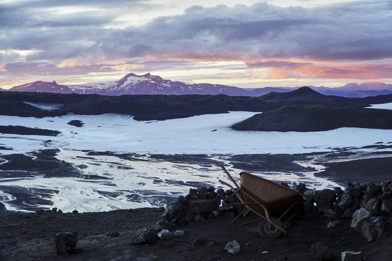
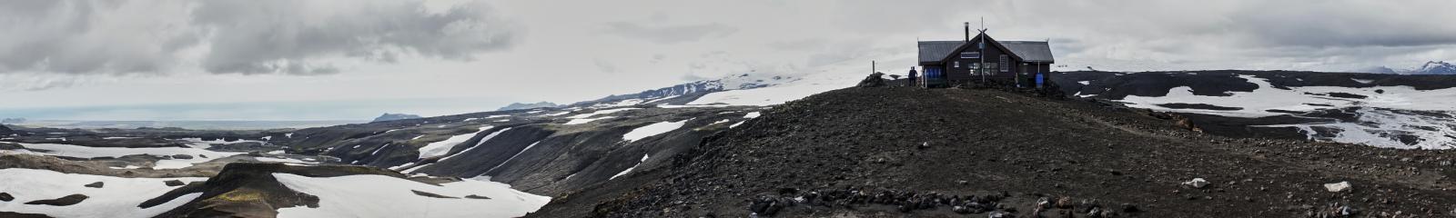
Wir sind die Etappe von Dana nach Petra im Oktober 2018 in 4 Tagen und ohne Guide gelaufen. Kann mich nur anschließen, dass es eine absolut beeindruckend und gänzlich andere Hiking Erfahrung war als das was wir bisher gemacht haben. Wirklich schwer in Worte zu fassen. Andere Hiker haben wir auch nicht getroffen und stattdessen die Einsamkeit und hin und wieder den Kontakt mit ein paar Beduinen genossen. Nur um little Petra und in Petra selbst war es dann mit den üblichen Tagestouris recht überlaufen. Was die Organisation angeht, sofern man es ohne Guide probieren möchte, sollte man in jedem Fall ein GPS dabei haben. Trail-Kennzeichnung ist absolute Fehlanzeige und manchmal ist man selbst mit GPS am suchen. Die zweite große Herausforderung, wenn nicht gar die größte ist tatsächlich das Wasser. Etwa auf halben Weg zwischen Dana und Petra gibt (gab?) es zumindest einen kleinen Bachlauf, der in unserem Fall auch Wasser führte. Wäre das nicht der Fall gewesen, hätten wir tatsächlich ein Problem gehabt. Davon abgesehen waren alle eingezeichneten Quellen versiegt oder wir haben sie nicht gefunden. Am besten fragt man am Ausgangspunkt in Dana im Dana Reserve Office ob jemand zu Quellen oder dem Bächleich Auskunft geben kann. Am Ausgang der Dana Schlucht gibt es dann noch ein Eco Ressort, bei dem man ein letztes mal seine Wasserreserven auffüllen kann. Ein Tipp vielleicht noch für little Petra. Wir hatten das Glück von einem beduinischen Besitzer eines Touri-Kaffee-Zeltes am Eingang angesprochen zu werden, ob wir nicht in seiner Höhle - ja Höhle - übernachten wollen. Wir waren zwar zunächst sehr skeptisch, haben uns dann aber doch darauf eingelassen. Die Höhle lag 200m vor little Petra in einem großen Felsblock, war mit einer Tür versperrt und im Inneren mit Teppichen und Matratzen ausgelegt. Der Besitzer hat uns dann sogar ein super leckeres Abendessen vorbeigebracht und mit uns gespeist und erzählt, bevor er wieder nach Hause ist. Nachts und auch Abends hatte man dann vom Felsblock aus einen wunderbaren Blick auf little Petra und den Sternenhimmel. Wadi Rum im Anschluss würde ich auch noch empfehlen. Falls nicht zum wandern, dann doch zum ausspannen in einem der vielen Beduinen-Camps.3 Punkte -

[AL, MNE] Peaks of the Balkans Trail 2019
cafeconleche und ein anderer reagierte auf sja für Thema
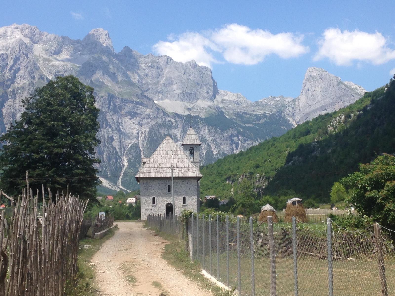
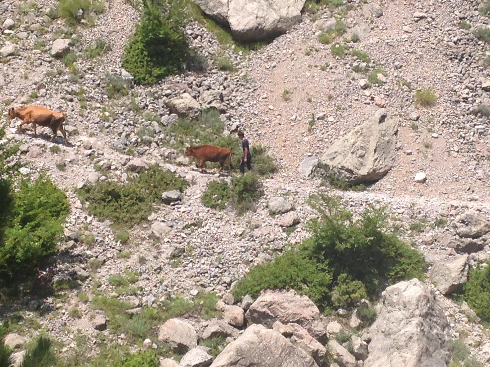
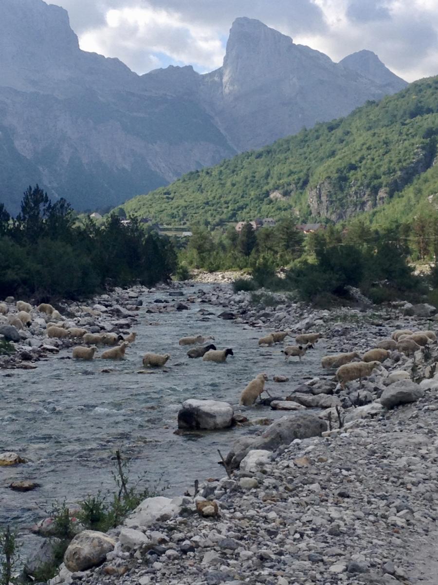
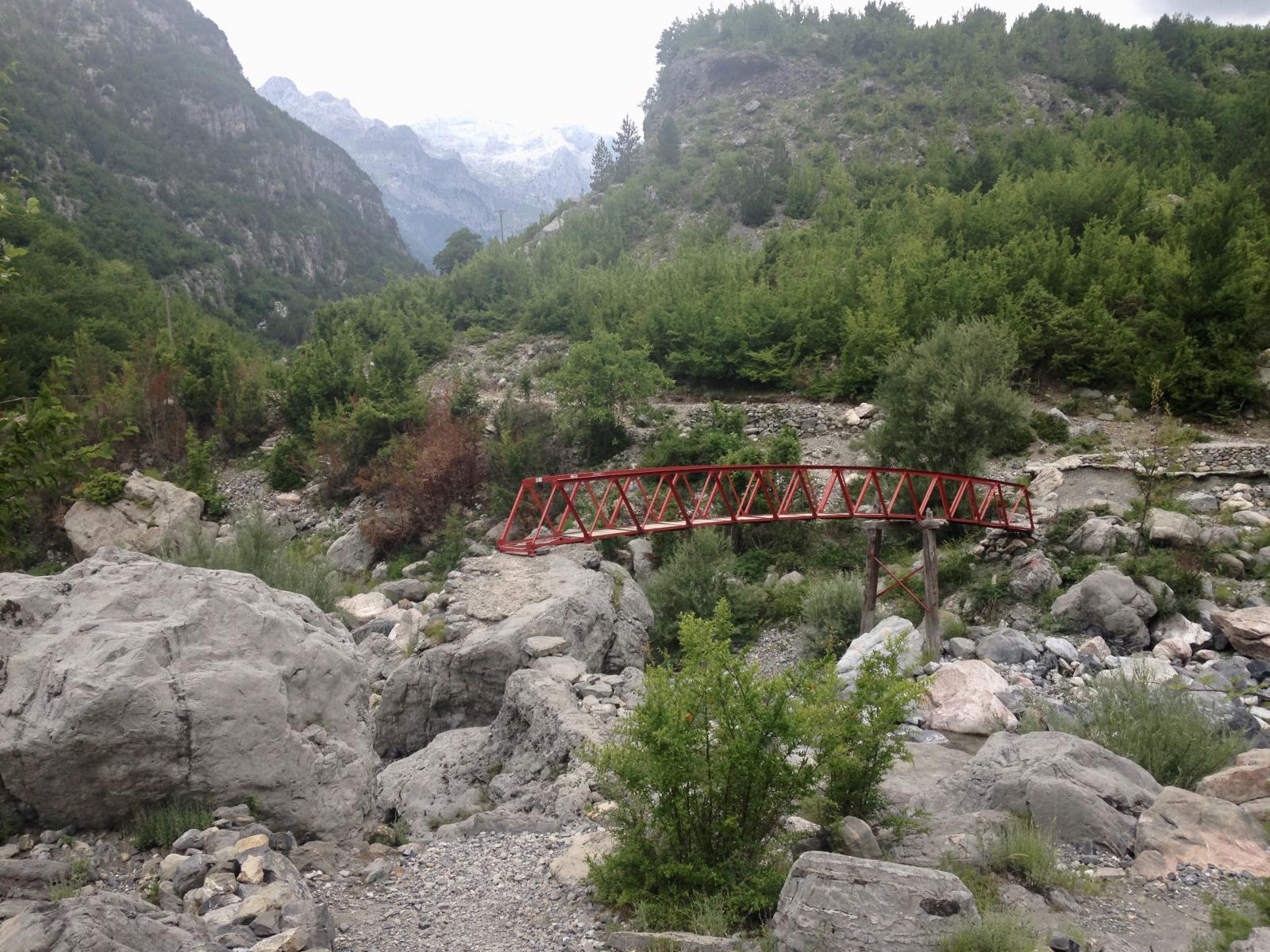
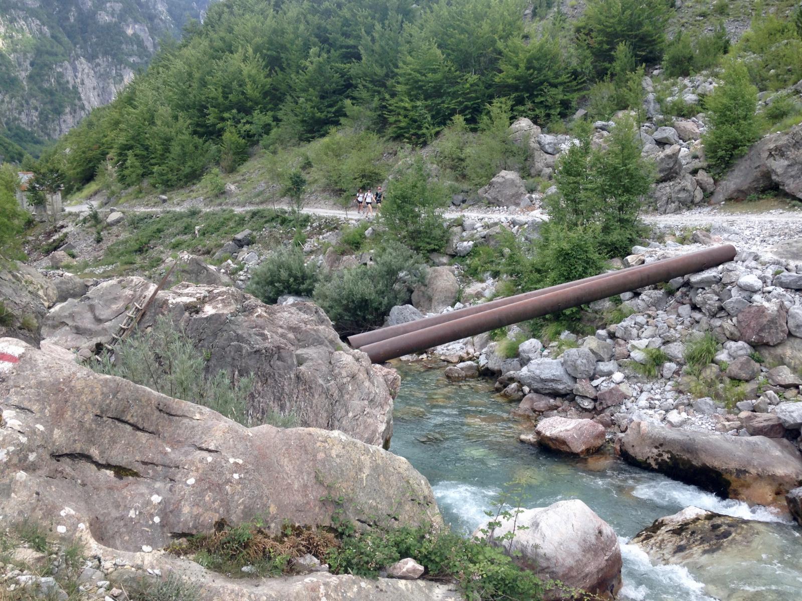
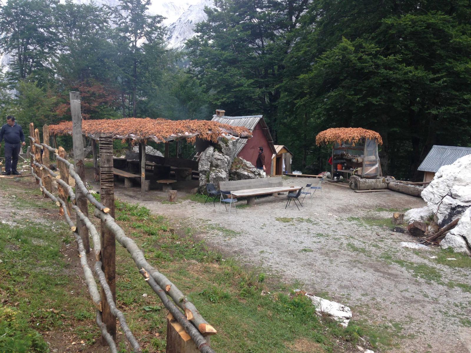
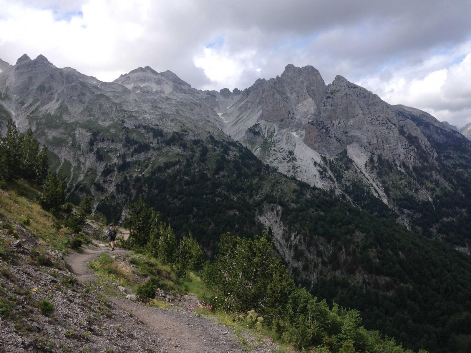
Der Peaks of the Balkans Trail ist ein Rundweg durch Albanien, Kosovo und Montenegro. Ungefähr 185 km lang erstreckt er sich über 11500 HM. Der Trail wurde von der Deutschen Gesellschaft für Internationale Zusammenarbeit (GIZ) in Kooperation mit lokalen Nichtregierungsorganisationen und dem Deutschen Alpenverein entwickelt und 2011 mehr oder weniger markiert. Ziel ist es u.a, die wirtschaftliche Situation der Grenzregionen zu unterstützen und zur Versöhnung der Bevölkerungsgruppen beizutragen. Man wandert auf bis zu 2200 Metern Höhe im wilden, schroffen Prokleitje-Gebirge, auch als die “verfluchten Berge” bezeichnet. Der Weg ist in 10 Etappen mit unterschiedlichem Charakter aufgeteilt. Es können natürlich auch Varianten eingebaut werden oder die “Peaks” bestiegen werden. Auch sind Abkürzungen auf beispielsweise 1 Woche möglich. Der Einstieg erfolgt wahlweise in Albanien, Montenegro oder dem Kosovo und ist mit öffentlichen Verkehrsmitteln erreichbar. Eine Freundin ist den Trail schon vor vielen Jahren gegangen und war sehr begeistert. So stand er lange auf meiner Liste, damals war er aber noch recht schlecht markiert, bzw. die Orientierung nicht ganz einfach… Die Markierung wurde mittlerweile verbessert (wobei es immer noch zu Verwirrungen kommen kann und es im Kosovo etwas schlechter aussieht, wie man mir sagte). Dieses Jahr war er also dran. Es gibt meines Wissens 3 Guidebooks. Das erste erschien im Conrad-Stein Verlag,, dann gibt es mittlerweile eines von Rother mit GPS-Track (+ Varianten und Tagestouren) und einen englischsprachigen von Cicerone (auch als e-Book). Mein Plan war, eine Woche mit einer Freundin unterwegs zu sein und knapp eine Woche alleine. Wir sind in Theth (Albanien) gestartet, haben den Kosovo ausgelassen, damit meine Freundin nach knapp einer Woche in Plav (Montenegro) aussteigen und gut wieder zum Flughafen kommen konnte. Ich hatte dann noch ein paar Tage Zeit für die letzten beiden Etappen zurück nach Theth, Varianten oder Tagestouren. In den Etappenzielen, kleinen Dörfern, Almen kann man in Guesthouses und Home Stays übernachten und bekommt dadurch einen netten Konakt zu den Leuten und einen Einblick, wie sie so leben. Sie bieten Abendessen und Lunchpakete an (durchschnittlich kann man für den Schlafplatz und Essen so ca. 25 Euro pro Nase einplanen, in Theth oder den Städtchen abseits des Trails evtl. etwas mehr). Häufig kann man auch auf der Wiese hinterm Haus zelten. Einkaufsmöglichkeiten gibt es eigentlich nur in Plav (MNE) und Gusinje (MNE), in Theth (AL) gibt es nur einen kleinen Mini-Markt, allerdings hab ich da kein Brot und Käse gesehen. In Vusanje (MNE) gibt es noch einen Kiosk, den habe ich allerdings nicht begutachtet. Auf manchen Etappen gibt es von Einheimischen betriebene kleine Waldbars, wer unterwegs zelten will, kann wohl auch bei den Hirten Käse o.ä. kaufen. Verständigen kann man sich in den Gästehäusern auf englisch, wenn irgendwo kein englisch gesprochen wird, werden die Kinder hinzugezogen. Im Kosovo gibt es wohl auch immer mal wieder Leute, die auch deutsch sprechen. So genug der praktischen Dinge. Nach und nach will ich von dieser Tour berichten und ein paar Bilder zeigen. Es hat mir sehr gut gefallen. Ich würde gerne nochmal hin fahren und den Kosovo nachholen. Bis auf die trubelige Etappe (Theth - Valbona) war nicht viel los in den Bergen, ich habe tolle Bergpanoramen, die schönsten, unberührtesten Bergwiesen gesehen, bin sehr netten Menschen begegnet und sehr zufrieden wirkende, frei in der Gegend rumlaufende Tiere der Einheimischen (Kühe, Schafe, Ziegen, Pferde, Hühner…). -- alle Bilder meiner Beiträge in diesem Faden sind von mir -- 2 Punkte
 -
Küchenkonzepte für kurze Touren
immermüde und ein anderer reagierte auf zeank für Thema
Darf ich vorstellen, eine kolbottenpanna: https://www.xxl.se/hallmark-kolarpanna-diameter-28-cm/p/1137055_1_style2 Punkte -
Küchenkonzepte für kurze Touren
zeank und ein anderer reagierte auf Andreas K. für Thema
Schau Dir mal bei folgendem Windschutz den Verschluss an: https://de.aliexpress.com/item/32957057812.html?spm=a2g0o.productlist.0.0.7f253d9f6ZdIPm&algo_pvid=8cd58520-e8a0-4a89-9053-7deabf97e114&algo_expid=8cd58520-e8a0-4a89-9053-7deabf97e114-2&btsid=3cefc781-2dcf-41c1-9077-c90ec2d875b9&ws_ab_test=searchweb0_0,searchweb201602_7,searchweb201603_53 Habe ich schon mehrfach erfolgreich kopiert2 Punkte -

Küchenkonzepte für kurze Touren
immermüde und ein anderer reagierte auf Painhunter für Thema
Esbit ist einfach super. Leicht, idiotensicher, safe, gut transportabel, bestens kalkulierbar und effizient. Der Geruch ist ebenfalls in einem für mich vertretbarem Rahmen!2 Punkte -

Pakistan Trekking 2018
Christian Wagner und ein anderer reagierte auf thedutch für Thema
Hallo Trekking Community, da Deutsch nicht meine Muttersprache ist und es für mich einfacher ist auf Englisch zu schreiben hier mein Reisebericht zum Trekking tour in Pakistan im Sommer 2018 mit mein Freund Davide. Viel spass beim Lesen. We are (David and Davide) and have been friends for a long time. The idea of this trip started many years ago as I (David) travelled through Pakistan in the mid-nineties. From that moment on I have always longed to go back to this fascinating wild country with beautiful mountains and hospitable people. As alone is no fun I asked my friend Davide to come along on the trip and as you can read in my blog, he did! Davide and David with Hunza valley Our Intention: Cross the Thui pass to Darkot (upper Yasin valley) from there cross the Panji pass to Ishkoman valley, continue the trek to Naltar valley and from there cross over to the village of Sherqilla. On our first day in Pakistan, Chitral police told us that we could not cross Thui pass due to security. Luckily I had plan “B” so we went for the Nazbar pass that would also get us to Darkot. But as you can read things worked out a “little” different. Day 1.We flew from Frankfurt to Istanbul were we had a connecting flight to Islamabad. Arrived in Islamabad early morning 3:45 as pre-arranged by a friend we were picked up by our driver Ashgar who would take us to Chitral. But first we needed some money and it was not very obvious where the ATM machines where hidden in the airport. But after a bit of asking we were shown by two heavy armed guards in what corner they were hidden. After finding out that Mastercard didn´t do the job but Visa did we left the airport for our Toyota corolla. The first bit of travel was in the dark but then slowly we got our first glimpse of Pakistan. We drove to Malakand were we encountered the Pakistani police check post and were to find out that there were many more to follow. For Davide it was the first time to Pakistan and for him it was just like driving through a documentary with three slight differences and These were; you could smell , feel the heat and last but not least the dust in your face. Our driver was a kind of mixture between Niki Lauda and Michael Schumacher and he would drive as fast as the car would and overtake other traffic where he could. No faces smiled at him during some of his moves. Slowly driving in to the mountains it got les sticky and more scenic. We passed a few police post and handed out photo copies of passport and visa as if they were more important than our actual passports. When we got close to Dir I got a bad feeling at another police post were the officer required a NOC (non objective certificate) .Without an NOC we could not continue our journey. I tried to convince him that no more NOC for travel to Chitral is needed for foreigners but he did not believe me. Why did I not take a newspaper print with that Information! In the end Ashgar conviced him that we did not need the NOC. Ok we could travel on but the officer told us don´t stop or get out in Dir. So of we went up to the Lowari tunnel, of course with passing through a few more checkpoints. The mountains in this area are still forested and are a real pretty sight. Lot of beggars on every corner of the way with little plastic basket were people can drop a few rupee´s. On these steep mountain cliffs with no room for agriculture and no industry present it must be hard for the people here to earn money. What are all the kids going to do when they grow up? The Lowari tunnel (8km) that has only been finished a few years has less than 10% of the lights in order and as lots of Pakistani cars and trucks don´t have functioning lights it is a pretty scary thing driving through a tunnel with the feeling a car or truck could just bump into you. Finally we made it out of the tunnel and we had a feeling of looking in to the holy land. Driving towards Chitral the land got more and more barren and spectacular. Eroded cliffs and the “Chitral” river far below. Ashgar please don´t make a mistake or break an axel because we don´t want to end up down there (dead). Two hours before Chitral we had a lunch break and for Davide it was quit an (first) experience having lunch while all other men (no woman) in the room watched us foreigners. Of course I didn´t take long for the first guys to ask us where are we from and and and…Davide felt at ease! Arriving in Chitral the first thing was that Asghar took us to the police Station because all foreigners must Register when they enter Chitral. A police escort was organized to take care of us and we were told this is necessary because of security risk. I asked if our trekking tour could start at Gazin for the Thui pass trek but the answer was no and the word we would hear over and over again was “security”. I was more scared of my security in the Lowri tunnel as the days spent in Chitral. I guess it just the way you look at it! Ashgar took us to the Hotel of our choice by the name of Al Farooq. We took a little rest, and after that we had the hotel owner call our police escort who took us to a local restaurant where we had a delicious Pakistani meal. On our way back we met up with a German tourist and had a chat on the roof of our hotel. We did not realize that this would be the only tourist for the next three weeks to come. Chitral from our hotel rooftop Day 2. We trotted around Chitral a bit but not without our armed guard. We tried our luck on the ATM machines to find out that they only do VISA card. Even though most have master card signs on them. Had some lunch in a typical little restaurant were the owner was pride to have us. The other people having lunch were surprised to see us foreigners. Chitral is a nice little town and to us everything looked save and we never had a glance of anyone that did not show pleasure at seeing us. Late afternoon our guard took us down the river. We passed an old fort that had seen better days. At the river our guard asked if we wanted to share a joint with him. We thanked him and told him we don´t smoke so he smoked the joint by himself. We threw a few stones in the river enjoyed the last rays of sun and walked back to town. Our guard walked slower and slower. We wondered why? We went for dinner at a local restaurant where we run into a handsome looking guy with a beautiful beard and long hair. He could have been a Taliban chief or a model for some fancy label. He turned out to be a doctor working for the WHO. He was responsible for polio vaccinations in all of the area north of Chitral. He talked in perfect English without a break. Interesting guy with a lot of knowledge of the area and it`s people. One part of what he told me really stuck to me. “A father in a far of village high up in the mountains did not want to vaccinate his children because he thought that the vaccination was a jewish try out on the Pakistanis population to manipulate them. The doctor asked him if he and his kids drink Coca Cola. The answer was of course! The doctor replied, the Coca Cola company is owned by jews and it would be much easier to put some drops in every bottle than travel through Pakistan and vacinate childeren. After that the father had his kids vaccinated. By the way if he would have refused the doctor had full power to call the police and have the father send to jail. After this long and interesting talk our guard brought us back to the hotel. He was so stoned that were luckily not walk in to a security trap because we don´t know if he could have been of any help to us. Our guard in Chitral Day 3. At six in the morning the jeep that was arranged through my friend Imran was going to take us via Mastuj across the Shandur pass to the village of Phandar. The jeep driver was “uncle” how spoke no English and the interpreter was his nephew. The ride was a great one and we could not stop gasping and taking pictures. Shortly out of Chitral the road got rough and bumpy but this was the Pakistan we came for. We swallowed lots of dust and cleaned our throats at the next tea break at some local truck stop. The mountains where rough and barren except were there was water that was was irrigated through small channels. High up some of the valleys we could see huge glaciers. Nephew told us while passing a village that a few years ago the glacier broke loose and destroyed half of the village below. How tragic, these people that have so little and then they even lose all that they have. And let’s be honest about it, nobody here has insurance on a scenario like that! From Mastuj the road wound up the mountain side towards the plain of Laspur. The higher we went the more we felt how small as humans we are I this incredible landscape. Landscape between Mastuj and Shandur pass At some point we passed an electrical turbine generating plant. What a good thing to see that some positive things of modern world have found its entrance in this almost none developed area. Short before Harchin, we were stopped by one of the many police check post on the way. But this time all was different. The Police told us we had to take an armed escort with us. Only when I told them that I was willing to sign some paper that we are here at our own risk and we don’t need an escort we could move on. The road went up towards the Shandur pass from here. Spectacular landscape with the beautiful village of Laspur shortly before we went up the last climb to the Shandur pass. I am sure that there are lots of hiking trails here to be discovered but as long as the police wants foreigners out of this area these trails will stay hidden for many years to come. Finally we reached the Shandur pass. What a place to be at the end and on top of the world. The lake, the surrounding mountains and the clear blue skies, mind blowing! I have seen a lot of mountain scenery but this place is special. After a few photos and yet another check post we passed the polo ground and a few Gujars (semi nomadic shepherds). We rolled down the mountain into Gilgit Baltistan province. At Bharsat we had to stop at the next check post. The police guys looked a bit stressed, maybe because they had to take our photo with a way to advanced camera. It took quite a while till things were done but finally we were proud owners of a special identity card that we should carry with us wherever we go in Gilgit Baltistan. The next few hours we passed through little villages, one prettier than the other but the thought of having to life there was not appealing. The drive through Phandar village is very pretty with that beautiful shining blue river in the back ground and the villagers harvesting their wheat. This place could truly be a pure tourist magnet with the right tourism management. The end of the trip was the PTDC guesthouse, a wonderful place overlooking a little lake. We said goodbye to uncle and nephew and checked in to our reserved room (not possible to just show up at a PTDC without Reservation although the place was almost empty). We had dinner in the PTDC restaurant with more waiters than customers. Shandur pass Day 4. Next morning we prepared all our gear for the hiking tour and left at 10:00 for the bus! We didn´t dare to tell anyone about our plans because we had a feeling that “security” would get us out of the area as quick as possible. We walked down the road instead of taking the bus, took some selfis with some Yyung guys and said hello to all the friendly people we met on the way. After one hour we reached the village of Shamran from where we walked of in to our mountain valley towards Nazbar. After leaving the village we made a lunch break and congratulated ourselves that we did it. We were just happy walking up our trail. For Davide it was the first time in terrain as rough as this and he was kind of high on seeing all this natural beauty. The trail to Nazbar an We passed some farmers preparing for winter and harvesting grass for their animals. Small water irrigation channels on the mountain side that must have been there for generations. We were just happy. At 16:00 we decided we had enough for the day with our heavy packs (20KG) and found a nice camping spot. We unpacked our bags and had our candy bar and all of a sudden two police men showed up telling us that we could not be here, security, terrorists and all the rest of it. We tried to convince them that what we are doing is legal we have permission from the ministry of tourism and we are in an open trekking zone but they told us we had to come down as we are under terrorist threat. Even the fact that we were tired didn´t count. They would carry our packs. So we repacked and there we went back down the same trail we came up. On the trail they told us that local people saw us and that is how the Pakistani intelligence got informed. Further down the trail we were joined by a few more officers and “escorted “down . After reaching Shamran we had a quick cup of tea and some dry chapatti (the eggs that came with the chapatti were quicly eaten by the police and nothing was left for us guests!). Still hungry we were taken to the “save” police headquarters in Phandar in a police Suzuki jeep. What a day and what a journey. We were to tired to really understand what happened. Why did we have to sleep in a dirty police station and were not allowed to stay in a hotel? Nobody could tell us. What we were told was that we would meet the police commissioner of Gupis tomorrow and he would solve all our problems. Slowly we got to the point that we believed none of these “stories and promises” anymore. The question that came to our minds was if we were going to do any trekking at all? Did I choose the wrong country? The police that orderd us back Day 5. After a short sleep the police woke us at 5 in the morning and told us to get ready as soon as possible because the minivan was waiting. There we went, back packs on top of the van, the two of us in the van with about 18 more people (my pore legs and knees) and no police escort. Maybe it is not that dangerous after all and the local police just wanted us out of their territory. In Gupis nobody took us to the commissioner, instead a police man got in the van and joined us to Gahkuch. Finally we got out after being squeezed for three hours and the police man took us to the police station and left without saying a word. Wauw, what a journey! Is this adventure or is this crazy? In the police station we met with a young guy who told us that the commissioner would see us if his time would permit. That was a downer and we had the feeling that all was going wrong. On top of that the young guy told us that we should arrange some trekking agency if we wanted to trek in the Hindukush because the chance of a permit for the two of us would be close to zero. In the mean time we sat in an office were the cartridge of the printer was taken out and brought back all the time, we figured out that they probably had a few printers but just one “full” cartridge for all offices. Without us knowing the young guy phoned his uncle who had a local trekking agency who then showed up at the police station. The uncle, a very friendly guy called Ayub informed us that even with his help things would not be easy to make arrangements. We decided that the best would be to go for his help. We went to his office that was in the same building as the Pakistan tourist Information. The Tourist Information was deserted, 6 people should be working there but they had “Tea” for the rest of the day. So no help to be expected from them. Together we walked back to the police station were we waited for an audience with the commissioner. After some time we could enter his office and Ayub pled for trekking permission. The only thing we understood was the fact that the commissioner looked very serious and only shook his head as a sign of no. Both of us felt that this guy was the one that held the key to yes or no, and things didn´t look good for us! After the conversation in Urdu was finished we left the room and Ayub told us the outcome. If the deputy commissioner who is also responsible for security n the aera would give his permission then the commissioner we just saw would also give his permission. Until today I never really got the difference between the commissioner and the deputy commissioner but we westerners don´t really have to understand all. The deputy commisioner was a friendly guy who talked English with us and we had the feeling that luck was turning to our side. So with his permission we went back to the gloomy commissioner who finally set his signature on the paper that Ayyub had prepared. It sounds like we just did this in less than an hour but in reality it took us more than three hours. With Ayub we went to a bakery and bought a cake for his sons 18-th birthday, then took a minivan to Birgal in the Ishkoman valley where Ayub runs a small guesthouse with his brother and two friends. We arrived and had a cup of tea and shared the birthday cake with his son and had the feeling that things turned out positive for us. That afternoon we discussed the details about the treks we decided to do. The co-owner of the agency is Ayubs longtime friend Murrad who would be our guide for the next 15 days to come. For Murrad it would be his first trekking tour without a full team of porters and cooks. We noticed that he felt a bit concerned but as we presented our food and equipment he got a better understanding of us guys and what we wanted to do. The cook of the guest house prepared some delicious trout and after great dinner and a long talk we went to sleep. Day 6. Our second adventure try started. Early in the morning a jeep picked us up and we went for the upper Ishkoman valley. In Chatorkhand our papers were checked by the police and on we went. We picked up our guide Murrad on the way. He told us that he was informed by the police that we could not travel on and had to go back to the Chatorkhand police station. Was that going to be the end of our trip? After a bit of discussion between Murrad and the police we were permitted to continue. So of we went again on our second try. We had some amazing views of the wide Ishkoman valley as we drove up to Ishkoman village that would be the starting point of our trekking tour. The drive up to Ishkoman We were stopped one more time for a police check at lower Imit. Upper Imit is restricted area for tourists, as is the upper valley that connects with the Afghan border. In Ishkoman village Ayub and Murrad arranged a porter. We had tea with salt at the porters house while he packed his stuff. His name was Rashar, he spoke good English so we had some very good conversations for the days to come. The first trek we went for would be the crossing of the 4680m Punji pass that connects the Ishkoman valley with Yasin valley. We walked of with good weather and all us of us in a good mood. Slowly we moved higher up the valley stunning at all the natural beauty of the mountains, The local people living in these valleys (most of them shepherds producing butter and cheese) lead a harsh live. But as soon as we are seen they come up to our little group offer us tea, chapatti and butter. All of them are curious where we are from if we like it here and many more questions. They told us that it has been quite a few years ago that foreigners passed through this valley. What a pity such a beautiful country with such hospitable and friendly people and almost no tourists. After a short walking day we pitch our tent on the side of mountain close to a little stream coming down a gully. After a quick wash our famous noodle stews was prepared for the first time and even our guide Murrad liked it (even if he did not like it this was going to be the dinner for all the nights to come on our trek). All the tours he did until now had been with big groups, kitchen tents, lots of porters and local Food (No Aldi noodle stew from Germany). First day on the Panji pass trek Day 7. After a good sleep cows from the local shepherds walked by and woke us. We had breakfast, coffee, tea and muesli. Our guide and porter preferred their own chapatti they brought with them. Well they are not the only ones that don´t like muesli. I did a 10 day trekking tour in India 1995 with my dad and he had to eat muesli every morning. After that tour he never touched a bowl of muesli again. We went up the mountain passing a few more shepherd huts were we had tea, chappati und butter “again”. My friend David slowly got to the point that he couldn´t eat the butter anymore. He said it was like the smell of goat was added to the butter. One of the sad things about the butter production is that we in Germany pay less for a KG of butter as the Pakistan shepherd sells his for. Don´t fall down! We got close to the first “hanging” glaciers and it was as if we could almost touch them. End of the afternoon we reached the high altitude plane of Holojut at 3800m. Camp was set close to a spring with spectacular views all around us. With the bit of fire wood we could find we lit a campfire and had our three *** dinner. Shortly after it started to rain with strong winds so of to bed we went. Holojut Day 8. Next day was the day of the Punji pass, unluckily the weather didn´t look to good. We reached the end of the plain and at the moment we started our ascent it started to rain. Bit of a bummer, scree ascent and rain, but nothing to do about it. Murrad had enough experience as a guide to keep our spirits high! The higher we went, the worse the weather got. So we reached the pass in the snow. What a shame, standing on a almost 4700 meter pass and no view. After a view pictures proving we had reached the top we struggled down the pass in the snow until we hit the glacier and the moraine. Difficult to say what was the glacier and what was the moraine was with all the rumble on the glacier. Coming down the glacier was a bit of a slippery act and all of us lost balance and ended up with traces of mud on our pants and gear. Close to a stream and next to a shepherd shelter we camped. Pakistani mountain men love campfires so of we went in search of fire wood. It all made sense as our Porter Rashar had wet shoes and feet. After another cold night (not in our sleeping bags) we woke up with a clear blue sky. Panji pass 4680 meter, from left to right; David, Davide and Murrad Day 9. Of we went down the mountain towards Darkot. It was a pleasant walk with the sun burning on our necks. After a few hours we reached the village of Gartens. All looked very idyllic but a close look showed that some fields had not been tended, the first signs of rural depopulation? I must say that walking through an area/village like this is a beautiful experience. But what if you had to live here during winter? Would I want to stay here for the winter, rest of my life? I have asked myself this question over and over again at various hiking trips all around the world. To be honest the answer is no. We reached Darkot village at 2700 meter early afternoon. . Two chairs were set up for the two foreigners at the local shop. Murrad went into the village too see if he could organize some sort of transport to Yasin. Darkot lies at the end of Yasin valley and the road ends here. It is surrounded by 6000 meter peaks and glaciers, the only way out is down the road that hardly should be called such. The other direction is towards the Darkot pass direction Wakhan Corridor/Afganistan. We just sat there and enjoyed the sun on our bodies. The only thing negative was all the plastic surrounding the shop. This is one of the things that really caught my eye during our tour of Pakistan, plastic, plastic everywhere. Will the Pakistani people notice this before it is to late? After an hour Murrad came back with a young guy and a car or what used to be a car. I think I have never ever traveled in anything worse than this. Literally it was stitched with steel wire. The road was so bad and bumpy that even with an of road motorcycle you had to have quit some driving experience to drive this road (or should I say track). Somewhere down the road we stopped at a few house and after some conversation someone came up with a hand pump. Our right front tire was losing air rapidly. The driver and the pump-owner pumped till they turned red and of we went. While driving the car across a recently flooded area it all of a sudden stopped. What a laugh, in the middle of these boulders and water passing behind and in front of us our car just stopped! Well I decided this is adventure and not my car and not my problem so let’s see what happens. The driver must have been some kind of mechanic or this “incident” happened before because after 15 minutes he got the engine running. So there we went again, Yasin we are coming! The road got better and more and more inhabited along the way. Before reaching Yasin, Murrad explained us that the Agha Khan visited the area a few years ago and the main gathering of his followers was in Yasin. 200.000 people came to this village that maybe has 5000 inhabitants. Finally it was clear to us why so many mountain sides in the area where covered with painted white stones and the words “welcome our beloved Hazir Imam”. That night we stayed at some relatives of Ayub. We had a nice hot shower and looking back one of the best meals we had in Pakistan. The three of us had a room to our self’s with matrasses and blankets. Murrad told us that most people in Pakistan prefer to sleep on the floor and don´t have beds. We left our shoes and smelly socks on the porch. After dinner we went to our room and sorted out things. My shoes were still there but my sock gone. Just as I realized this the old caretaker came around. Having a close look one of my socks was just peeking out of his pockets. I pulled them out and we all had a good laugh and then went to bed. If it would be me I would steal clean socks but not a pair of smelly ones! Murrad and Davide with Darkot in the background Break down in the flood Day 10. Next day we left for the Nazbar Ann trek. Davide had his first difficult night as he spend almost the same amount of time on the toilet as in his bed. But in the morning he felt Ok so there we went in a little 3 cylinder Suzuki Mehran that our host organized for us. It was a bit of a squeeze, four guys and three back packs but in Pakistan everything is possible. We had to get out of the car a few times as the motor overheated as the road or should I say path was pretty steep. What a sight, us guys getting out of that little car and helping to push it up the mountain. Well we got to a point that the little car just didn´t want to move anymore so we told the driver that this was it. He was such a nice and easy going guy that we sent him off with a nice tip. The start of the trail was trough cultivated area with scattered houses along the way. During our lunch break at Batakushi we had some of our nuts and chocolate and I pulled out my map and my compass and roughly figured out the pass far away. Murrad talked to one of the farmers that came for a chat. He told Murrad that the whole valley was forested until they build a tractor road 30 years ago. With that road the deforestation started until there was no tree left. Even this local guy felt sorry for what they did and what the valley looked like now. Probably just a few guys in the valley that made some short time money. We walked on through this barren valley. Higher up we passed some Gujars who spent the summer in tents with their cattle. Of course we were invited for tea but this time we thanked them and told them we wanted to move on and make some process. Late afternoon we set up camp close to a river on a flat piece of land and enjoying the last rays of sun. How beautiful live could be after I had my naked river shower and I felt so clean. Murrad and David just told me that I was nuts. I went into my sleeping bag feeling hmmmmmm and they had to go for the smelly version. Ha ha ha Camping spot on the way towards Nazbar an Day 11. Next day there was no cloud in the sky and after leaving our marvelous campsite we slowly walked higher up the valley. Before the climb started we met a shepherd who roughly gave us some advice were to go although even he had never crossed the pass. In “ancient times” people would cross passes but in modern times it is easier to walk down the valley and catch the bus that takes you to your “next” valley destination. So fewer and fewer are familiar with these high passes. From the moment we said good bye to the shepherd the trail went up steep. All three of us just figured out our best trail and went up the mountain in a sort of meditational trance. At the top of a scree field we reached a high up valley. A hugh boulder with a cattle wall would be exactly the right thing for our next camp. It was still early in the afternoon but too late to tackle the pass. This would be our highest camp of the tour at roughly 4500 meters. Murrad and I went for an exploration tour to see if we could find the pass as it was not visible from our camp. David decided to take a nap and relax. Before we went to sleep we played a game of scopa. I did not mention this untill now but we have been playing this card game (only known by people from the Napoli area in Italy ) every camping night. Murrad became a true professional and with his Italian looks and a deck of scopa cards he could pass for a real Italian from Napoli. On route to high camp Day 12.Next morning we got out early and no sun yet so it was freezing cold. The rocks in the little stream nearby were all covered with ice. But with the first rays of the sun, life became more and more enjoyable. We headed up the valley, climbed up a big moraine and walked up a small glacier that led up to the foot of the pass. The accent looked pretty steep. But as it is with mountain passes just put one foot in front of the other, don´t think too much, don´t look up to often and then all of a sudden you are on the top! Still I must say it was a steep accent and the last few meters didn´t allow any mistakes. We made Nazbar pass 4980 meters. What a view and what a beautiful day with almost no clouds and no wind. We climbed up a little higher to make sure that we did the 5000 limit and there we just sat and all three of us just enjoyed this beautiful moment. After an hour time had come to descend. A little “mini” glacier had to be crossed and from then on we walked down on moraines. Not that easy as it sounds hopping from rock to rock. We passed some very interesting looking side valleys waiting for exploration in my next life. For this life I just had to go down and it went down very steep. Looking backwards I was happy not to do this trail the other way round (that was how I had originally planned the tour). Finally we reach the Kano Gol valley, a beautiful broad valley with lots of willows and a little forests of juniper. We followed a shepherd who was tending a least 100 to 150 goat and sheep. Murrad sugguested that we do a BBQ tonight. What do you guys think? Let us talk to the guy. The shepard told us he could not decide that and had to talk to his wife. What a man Murrad said who can´t decide for himself and needs his wife! So we followed him to his hut for another hour and all we could dream of was this nice little roasted goat. We had sore feet but the BBQ kept us going. Finally we reached his hut and met his wife and two little children that looked kind of scared at us foreigners. While the tents were set up the shepherd came and told us he could not sell a goat as they were not his. This literally poor guy is nothing else than the shepherd for other people and scared as hell that somebody would find out that he sold a goat that wasn´t his. So for tonight no tasty goat, just a bowl of noodles (again). Ascent to Nazbar an Nazbar an 4980 meter Day 13. Next morning the sky was blue again and everything was just lovely. Down the valley the Kano gol met with the Bahushtaro gol and more and more trees in the valley. The mountains themselves had beautiful colors and it was a real pleasure to walk here. Close to the junction from where it is possible to walk toward Mastuj the valley gets wide and all looks peaceful. We meet a few shepherds with their livestock and that was about all. At the point where the valley gets narrow we got to a place where a huge avalanche dumped enormous boulders in the valley. It took us quite some time to pass this stretch. It must have been quite something when one side of a mountain just collapses and rolls down the valley. We were warned by the shepherds that we had to cross a tricky bridge and we thought we were tough and seen it all. But when we got there and saw the two logs with a few loosely stones slabs on top we had a good look around if this was the only bridge. Yes it was the only one, so there we went and made it too the other side. But we knew that a drop down in the river would not be funny. Slowly it was getting late and the question was what to do? Camp in the valley or move on to one of Ayubs brothers relatives in Chasi. If we´d camp in the valley we would have to make a very early start to catch a minivan to Gahkuch. Why do all the mini van´s travel so early? Anyhow we decided not to camp in the valley but to march on to Chasi. It was the longest day we did and in the end we reached the relatives house at 19:30. We had just done an 11, 5 Hour walking day. Without the breaks we must have walked for 10 hours straight. The family took us in with great hospitality and a nice meal was prepared for us tired guests. With full tummy´s the mattresses were rolled out for us and of we went to sleep. What a beautiful day Day 14. Next morning we had an early rise (no coffee, poor me, how can a good day start without coffee?) to make it to the road in time to get seat on a minivan. One thing that surprised me with Murrad was that he had some nice clean clothes hidden somewhere in his pack. So except for his unshaven beard he looked like a real gentlemen as we westerners looked a bit goofy. After a short hour waiting we got a seat on a minivan that took us to Gahkuch. At Gahkuch busstation we had paratha and tea for breakfast. I must say even with the paratha dripping with oil it was delicious. The shop owner was so happy to have us that every few seconds he asked if all was fine and where we were from. The Magic moment was spoilt as someone came rushing in to tell us that the next minivan for Chatorkand was leaving. We hopped on and there we went to our guesthouse. We enjoyed an easy afternoon and a quick hand wash of some cloths. After a good diner we packed for the last trekking section we would start the next day. The bus stop Day 15. Early morning we were picked up by a small little car that took us to the start of Phakora valley. This would be our last trek that would take us over the glaciated Naltar pass into Naltar valley to continue to Sherqilla.The first bit was walking along perfectly arranged water channels. After some time the valley got narrow and the correct word would be gorge instead of valley. One soldier and his gun could withstand a whole army here. Both of us were just overwhelmed by the scenery. By afternoon time it became pretty hot and now we knew why Murrad wanted to go for an early start. Midafternoon we reached a little village called Krui where we set Camp close to one of the local huts. Most people were out with their livestock and cutting grass for the winter to come. We just had a lazy rest that afternoon. While preparing our noodle bowl for diner all eyes were watching. We offered the small crowed a try but all refused. Later that night we all joined the locals in a smokey hut and had some tea with them. We felt smoked after a few hours in the hut. All in all a great evening although we didn´t have a common language. Narrow gorge on the way to Naltar pass Day 16. As we packed our stuff for the next day hike, Davide complained that he didn´t feel well. I asked him, what do you feel. His answers was something like a flue coming. I asked do you feel good enough to continue or shall we go for a rest day? He replied that he should be ok if we go slow. So of we went, Davide went slowly and it seemed like he had a lack of energy. I stayed close to him just in case. By noon we had a rest and he had a nap close to a gujar hut. He told us that the smell of the butter made him feel sick. We continued our hike but Davide went slower and slower. I already emptied most of his heavy stuff into my pack but he had no energy left. At some point we traversed down a riverbed and I could see that Davide could not control his steps anymore. I signed Murrad who was in front and told him that we cannot continue like this. After a quick talk we decided to go back to a spot we just passed so that Davide could take some rest. Here the two of us decided that he was definitely sick and the best thing was to go down to lower altitude. Our rough altitude was between 3300 and 3500 meters. We struggled back with poor Davide and reached Krui by late afternoon. I sped of 15 minutes before we reached Krui to prepare the Tent and Davide´s sleeping bag. As soon as he walked into our camp he collapsed on his mattress and went to sleep underneath his sleeping bag. Some villagers came to have a look. All had some idea why Davide was sick. The one they all agreed on was that yesterday tree elder villagers came and had a talk with us. According to the others they had the power to put a spell on someone. So that’s what happened! My opinion was that Davide got sick because he had something wrong to eat or to drink the night before. The question you may ask why didn´t I get sick. The answer to that is that I grew up in the bush bush of Ethiopia and I can literally eat everything without getting sick. That night we sat in the same hut as the night before. Murrad and myself had to decide what to do next. Davide was seriously ill and we had to get him down the mountain as quick as possible. Two shepherd brothers that were in the hut with us offered to take him down the mountain on their backs. I asked them if they were serious. Davides weight is 80KG. No problem they said we are strong mountain men. That night Davide rolled in and out of the tent many times because of diarrhea. The poor bugger was all I could think of. My poor sick friend underneath his sleepingbag Day 17. That next morning we walked back to Pakhora. Davide was taken on the backs of the two brothers whenever the trail went steep up or down. On the more or less straight parts he tried to walk himself. The brothers were unbelievable they ran up and down the mountain with this 80KG tourist on their back and swapped him every two, three minutes. All Davide could do was complain that the boys smelled so bad! When we got close to the road Murrad took off as fast as he could to organize a car for pick up. I told Davide, come on just a little more to go and then Murrad will be waiting for us with a car and it will be all over. The last bend and Davide did it. We put Davide in the car and off we went, straight to the hospital in Chatorkand. Foreigners in a local hospital in the Hindukush doesn´t happen to often so Davide was shoved into the doctor´s room straight away. After diagnosis he was brought into a room with four beds and one other patient. All of a sudden the room was filled with all doctors and nurses in the hospital. Davide was checked from top to bottom. Even a very modern computerized instrument for the checking of blood pressure and heart signals was brought in. The poor guy in the bed next to Davide must have thought who is this guy that gets VIP attention? Later the crew of the guesthouse came in with all the medicine orderd by the doctor. One thing about the Pakistanis, when it comes to the use of cell phones they are the best. Without us noticing all the prescriptions had been phoned of to the local pharmacist. The head of hospital himself came to set the needle in Davide´s arm . We watched, drank tea, held council next to the bed and just watched our poor sick friend. Davide fell asleep! After the first fluid bottle was empty another smaller bottle was connected and slowly we could see some color coming back in Davide´s face. After all was done the doctor came with 3 different strips of pills and told us at what time of the day they had to be taken. Last but not least Davide was released. Ayubs brother was waiting for us in his car that took us straight to the guest house. For Davide the ordeal was finally over and he could go to bed and rest. Late afternoon Murrad came by with flowers for the patient. That is what I would call great love and care for your friend. Davide as patient in Ishkoman hospital Day 18/19. I spent the next two days with a few walks along the country side. Murrad picked me up on the back of his motorbike for a walk on the opposite side of the valley. As him being from the area and knowing everybody we were invited and had to drink tea everywhere. We passed a farmer who was harvesting his almond trees he invited us to pick what we wanted. I gathered a bag full that I later ate in Germany with my family. Everybody agreed that they never had almonds that tasty. After these two days Davide was recovered enough and felt it was time to leave for Hunza valley. The guesthouse in Birgal, the best place around for Davide to recover Day 20. Next morning we got on a minivan to Gilgit. It was scary drive in the fully overloaded minivan, or was it because we had been offered the front seats next to the driver and were able to see all his takeover maneuvers. When one passenger left the Minivan and crossed the road in front of the van without watching he was almost killed by a car that overtook us. It was so close that the other car brushed him. After that everything was even scarier. As I told Davide before we went on the trip: I think the change of dying in a traffic accident in Pakistan is way higher than the chance of a terrorist attack! We got checked at many police stations over and over again. I am sure it is for everybody’s safety! Although I think that the number of people in Pakistan that die in traffic incidents is much higher as terrorist attacks. I wonder if the Pakistani government investigates this issue. We changed minivan in Gilgit and raced on to Karimabad on the KKH (Karakoram Highway). Compared to all those years ago when I traveled the KKH as a dirt track, the “road” may truly be called a highway now, although lots of stones and boulders block lanes on the “highway”. But I suppose they just fell down a few minutes ago! After roughly 5 to 6 hours minivan rides we finally made to village of Karimabad. How nice to move our long legs again after hours of poor blood circulation in a Minivan. We walked down the main street (there is only one) to find the Haider inn. The owner showed us a dorm as (all) low budget tourist take dorms. Well the two of us didn´t want a dorm but a room just for us and with a view. Our room was not ready yet so the owner cleaned the place. Well in our opinion cleaning is something else but the pakistani thing is to get the garbage out of the room sweep it and there you go. Same as they do at the Hilton Hotel! The room had a strange smell but things got even worse and as we opened the bathroom door. We were almost blasted away by the smell of the drainage. The room was not that bad as long as the bathroom was closed. Davide complained but I was tired and had a headache and just wanted to lie down and couldn´t be bothered too much about this typical backpacker hostel as you find all around the world. End of the afternoon I woke up and felt a lot better so we went out for some food. Finally after all these weeks we see the first western tourists. Even the guy with whom I applied for a visa in Germany was there. As I have noticed over and over again the backpacking world is not as big as we think it is. Rakaposhi morning view from the guesthouse terrace Day 21. Next day we had breakfast on terrace of the hostel with a spectacular sunrise and views of Rakaposhi, the surrounding mountains and the broad valley of Hunza. Yes this is a very beautiful spot on our planet! After breakfast we went on a day tour to see the Ultar glacier. The walk took us through Karimabad past the Hunza fort and then in to the gully of the glacier. Spectacular views of the backside of Hunza fort. Finally we got to the glacier that was a bit of a scramble but we made it. Impressive to see the glacier melting and stones and boulders rolling down. We scrambled down and made it back to Karimabad. We checked all the little tourist shops that have popped up since my last visit. Had a shower out of the bucket with “Hunza water”. Hunza water is glacier water that looks milky because of all the unfiltered sediments that still float in the water. People here seem to get pretty old and they blame the Hunza water for that! We played our game of scopa again and went to bed early like we have been doing almost every day since we arrived in Pakistan. Hunza fort Day 22. Next morning we were blessed with another beautiful sunrise. Even without a “real” coffee life was heaven. After that enjoyment we went for a day trip to a lookout point called eagles nest. The walk to get there was an adventure as a great deal of the walk was next to water channels and some of these are constructed directly on the sides of a cliff. One wrong step and down you go. And with down I don´t mean computer game with three more lives to go! Eagles nest is the top of a hill overlooking the Hunza valley with all its majestic peaks that surround it. Many years ago there was just the hill top, but as more and more (local) tourist started to come to Hunza more and more hotels popped up in the area. Just filter out all of this and it still is an amazing spot. We spent a long time just sitting there, enjoying the view and the sun warming us. We walked down through the valley passing houses dotted on the mountain side. Life looked so peaceful here; being in this spot in Pakistan it seems difficult to imagine all the problems these wonderful people in this wonderful country encounter. Friendly people encountered us, greeting, waving and passing warm smiles. Finally we reached the valley floor and walked to Altit fort. We walked through the old village and saw the signs that no photos were to be taken. So the locals were fed up with tourist taking their photos as if they were taking pictures of animals in a zoo. On our way back to Haidar Inn we had lunch in a little local restaurant were mama was the cook and served us. Passing my memory this was one of the only woman we met in Pakistan cooking and making a living. The place was full of flies, the walls decorated with newspapers but the food was tasty. That afternoon we did some shopping for our beloveds at home and enjoyed a lazy afternoon. Hunza valley, what a beautiful place to be Day 23. This day would be the last day in Hunza valley before starting our way back to Islamabad. As Davide missed out a big glacier on the Naltar trek we decided to go for a day trip to Hopar in the Nagar valley and see Barpu glacier. We decided to walk and hitch hike and see how far we´d get. On our way down to the Hunza river we were taken by a father who took his son to school and went out of his way to bring us to the bridge crossing the Hunza river. From here we walked up the Nagar valley on a beautiful blue sky day with lovely views of Ultar peak . Ultar peak After some time we were taken by a bank clerk to Nagar. From there we continued our walk. One thing that we did notice during our walk was that all the women were covered up and no hello from them. The people in this valley are mainly shia muslims. Can that be the reason? After some time we were taken by two school teachers from Hopar that made a deal with us. If we would teach in their school they would take us. That was a deal. At round about 12:00 we reached the school. After a quick encounter with the other teachers we were separated and brought in to the class room. The kids looked so interested in their pretty uniforms but as I asked some questions they looked shy and nervous. Basically I told them about live in Germany and our form of democracy. Of course I couldn´t keep my mouth shut that Pakistan is a beautiful country but that the garbage and plastic that can be found everywhere really spoils the beauty. After our teaching trip we continued the walk to the glacier. As Hopar is easy to reach from Hunza and the ride is beautiful I am sure that quit some tourist make it up here at high season. This was obvious after seeing the number of hotels and little tourist shops. Davide could not catch his gasp as he looked down on to the Barpu glacier from the side of the moraine. What a site, it is so big and the view so spectacular that it is not possible to put this down in words. We walked down a narrow path and walked on top of the glacier. What a magnificent feeling walking on ice. Barpu glacier We crossed the glacier and found our self a nice look out on the Moraine on the other side that connected to the next glacier. There we just sat looking out over two enormous glaciers lined with snow covered peaks. After one hour we had to leave this place to make it back to Karimabad before dawn. Again we walked and hitch hiked down the valley. Over and over we were confronted with mourning people (Shia muslims) that decorated shrines and mosques for the remembrance of the martyr Hussain who was slain many hundred years ago (this act lead to the separation in Islam). The mourning offered us rose water for a drink as we walked by. The next thing that blew our mind was a guy on a tall bike from. As we foreigners are happy to do some small talk among each other we stopped and talked about our experience. He was Spanish and cycled all the way from Spain through central Asia to Pakistan. An Engineer that quit his job because there was more in live that work! Good bye from our side, we will remember you as that “crazy” Spanish on his tall bike. Another car stopped and we hopped in and it took us to the Karimabad junction. We arrived just in time to hop on to one of those little Suzuki buses that was already full but we managed to hang on outside the bus. The dudes on the glacier Hanging on the bus. Day 24. This day we walked off to Aliabad to catch a minivan to Gilgit. We arrived in Gilgit a little late because of a detour that had to be taken as the road was blocked because of Shia Mourning parties for Imam Hussain. Police set the road block to avoid clashes between Sunni and Shia. In the past Gilgit area has been troubled by serious clashes between the two groups with high death tolls. In Gilgit we found a nice hostel. After dumping our gear we went for a walk in search of a Restaurant and found one. Davide was so happy when he saw that the menu had roasted chicken, so for him there was nothing else to look at. While entering the place I saw them hanging and they didn´t look very applying to me but as he looked so happy I couldn’t spoil his dream. So food was served and at the first bite of his roast chicken he almost bit out his teeth. The poor guy, so happy with his chicken but instead of a nice juicy chicken he was left with something called chicken but as hard as stone. The rest of the afternoon we walked through Gilgit and enjoyed the people, views, smells and the freshly pressed mango juice. We sped passed the Mosques were tension was felt in the air. Back in our hostel we asked the owner what his thoughts were about the Shia mourning that was basically cutting of all of Gilgit Baltistan from the rest of the world as the KKH and minor roads would be blocked for the main mourning day. This was kind of the wrong question as the guy took it seriously and started to give us a lecture about the great Imam Hussain and his “very” evil opponents. No wonder that things turn bad every now and then when people have “fanatical” visions like his. After the lecture of at least 5 minutes, were all I could do was nod to not infuriate the guy, he finally stopped and we had a little more understanding what the whole thing is about. After sensing the tension we decided it would be the smartest to leave Gilgit as soon as possible to avoid getting stuck and maybe miss our flight home. The same lecturing guy organized a taxi for early next morning. Fruit shop in Gilgit Day 25. At 6 the taxi was there and of we went with a driver who didn´t speak a word of English. He could be a Taliban with his looks and big beard but he was really friendly and although we could not communicate through words we did great with sign language. We went through several police checks, saw people pan for gold deep down the Hunza river valley. After an hour we got to the point where the Indus river enters the Hunza river. We passed (killer mountain) Nanga Parbat with good weather and had beautiful views of the mountain. Initially we planned to go to fairy meadows at Nanga Parbat basecamp but after we found out that a police escort was needed we decided not to go (we kind of just had it with police!). We felt so privileged to see all this natural beauty. I just sat in the car and stared at this amazing landscape, wondering what things would look like behind the mountain ridges. Shortly before the town of Chilas we had oily paratha breakfast and some tea before the driver turned off towards Babusar pass. Landscape and housing slowly changed and the valleys turned greener. On top of the pass there was a collection of tents and huts that served meals and tea (a nice and cold beer would have been great but don´t forget this is Pakistan). Since this road was “redone” most traffic coming from the Punjab takes this shorter route instead of the longer and more dangerous KKH option. More dangerous means that there have been quite a few bus hold ups and Shia and Sunni muslims killed and revenged each other. Going down the pass we drove through rolling green hills till we passed beautiful Lulusar lake were we made a brief stop. After the lake we entered the tourist area of Naran and Kaghan that is easy accessible from the Punjab. Although it was no holiday season we got stuck in semi traffic jams on the narrow roads. Hard to imagine what happens here when it is Pakistani holiday season. The valleys are lush with forests on their sides and it is not difficult to imagine that people want to spend their holidays here when the plains of Pakistan are “cooking”. The area is covered with hotels and guesthouse all along the valley. We passed a heavily guarded Chinese building site for a hydro power plant. The Pakistanis have a kind of joint venture thing going on when it comes to trade and construction with China (the new silk road). Not all pakistanis are happy with this. At lunch break Davide runs off to the toilet and coming back he tells me he´s got it again. ohhhhh shit! Walnuts are for sale everywhere in this area so our driver stops on the road side and buys a few bags of walnuts and of we go again. The strange thing to me is that they cost more as they do in Germany. Finally we leave the Himalayas and reach Abbottabad (Yes; the town where they found Osama). I thought this was a small town but it takes ages to pass through. As it slowly turns dark we reach Islamabad and to our surprise our pre-arranged hostel even has air conditioning. What a treat for the two of us. Tea stop on the way from Gilgit to Islamabad Day 26/27. I spend the last two days with a bit of walking around doing nothing special. We had difficulties getting connected to the internet till the owner of a bookstore told me that the government switched off all networks to avoid clashes between Sunni and Shia. Can you imagine in our western countries that the government just switches of all phone and internet connections? Had some great food during the last two days, did some shopping and had my shoes polished. As an experienced trail runner I decided to go for a run in the Margalla hills. I don´t really have problems with heath but the Margalla hills really got me. It was humid and hot! Nice thing about the hills is the view on Islamabad the huge Shah Faisal mosque and the wild monkeys. Day 28. On our last day we made a very early start for Islamabad airport and flew home. Prologue: We had a fantastic trip although not everything worked out as planned. Would I do it again? Sadly I have to say no. The first reason is that it is almost impossible to get a Pakistani visa as an individual traveller. The second reason; there is too much police hassle in the country that gave us the feeling we are not welcome. As an experienced traveler and trekker I do things on my own (as I did in the mid-nineties) and don´t want to be ordered to use a guide. The website of the Pakistani tourism department (government) notes that you can trek in open zone areas and are free to do so (all treks that we planned where in open zone areas). My overall opinion is the police don’t care about this they just want you out of their area as quick as possible. I am sure that there are a lot of reasons for these upper issues but I don´t want to discuss these in detail in this blog. I just wish the things noted above will change in the future so that more western tourist can visit and enjoy Pakistan. A special thanks to Murrad, Ayub and Zaman for their help and hospitality. If you have any questions feel free to ask.2 Punkte -
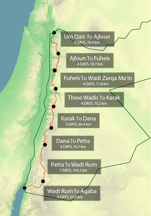
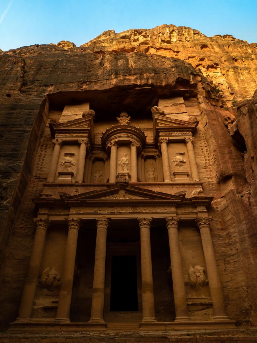
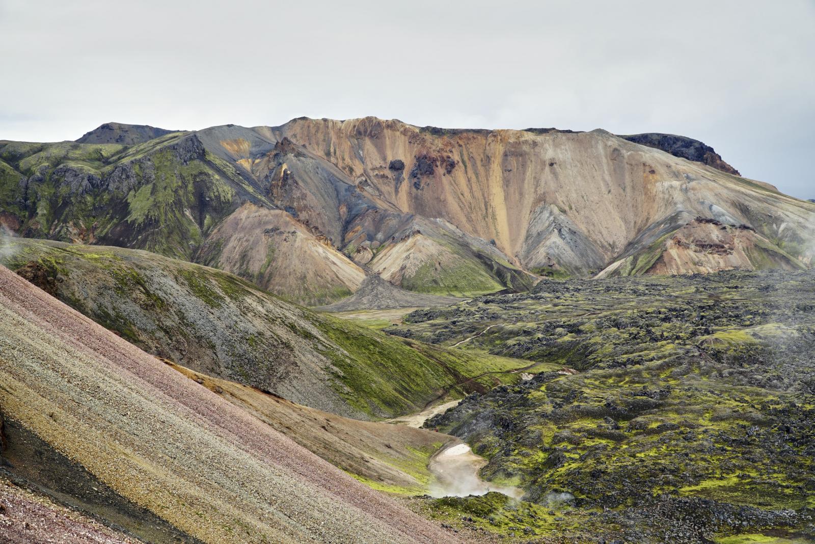
So, wie versprochen der Bericht über die kurze Wanderung auf dem Jordan Trail. Das Ganze gibt es eher in der Form einer Anleitung, als in einem Etappenreport. Die Landschaft, die Menschen, die Kultur - sprich alle Eindrücke vor Ort ließen sich sowieso nur äußerst schwer und sperrig in Worte fassen. Der Bericht dient hauptsächlich dazu, euch die Region schmackhaft zu machen und ein wenig Reisefieber zu wecken Wo: Jordanien - der Trail zieht sich von Norden, nahe Um Qais an der israelischen/syrischen Grenze für 650 - 700 km (je nach genauer Route) nach Aqaba am Roten Meer. Je nach Tagespensum braucht es vielleicht 35-45 Tage. . Quelle: https://jordanjaunt.wordpress.com/2016/12/03/about-the-jordan-trail/ (Abgerufen: 3.5.2018) Anreise: Die Anreise per Flugzeug ist hier sicherlich am einfachsten, wobei euch der Landweg durchaus auch offen steht. Es geht entweder direkt von Frankfurt in die Hauptstadt Amman (Lufthansa - ca. 350 € Return) oder über/mit Zwischenstopp in Istanbul (Turkish Airlines). Es gibt auch die Möglichkeit nach Aqaba zu fliegen, falls der Trail von Süden nach Norden gegangen werden möchte. Vor Ort gibt es eine schier unendliche Auswahl an Taxiunternehmen, die es ermöglichen zum Startpunkt des Trails oder der jeweiligen Etappe zu gelangen. Visum: Gibt es vor Ort am Flughafen für 40 JD (entspricht ca. 45 Euro). Kann mit Karte gezahlt werden Reisezeit: Am besten im Frühling oder Herbst. Die Temperaturen sind dann zwar gerade im Norden noch oder schon deutlich kühler (10 - 15 °C tagsüber) und es kann gelegentlich regnen, aber spätestens in der Wüste wäre es im Sommer eine Tortur (40+ °C). Im Frühling ließ es sich dort bei 30 °C noch einigermaßen gut wandern. Etappen: Wie Ihr dem Bild entnehmen könnt, lässt sich der Trail in mehrere Etappen einteilen - die unterschiedlicher nicht sein könnten. Der Norden ist hügelig, aber nicht bergig, im Frühjahr überzogen mit Wildblumenmeeren, grünem Gras, Ziegen- und Schafherden und dem einen oder anderen Dorf . Je weiter der Trail im Süden verläuft, desto trockener, und bergiger wird es, bevor es 2 Tage hinter Petra in die Wüste geht. Diese wird dann auch bis Aqaba nicht mehr verlassen. Im Süden werden dementsprechend auch die durchlaufenden Dörfer innerhalb einer Etappe gegen 0 tendieren. Jeweils am Etappenanfang und -ende befidnet sich jedoch ein Dorf oder eine Stadt. Ausrüstung: Anbei seht Ihr eine Liste von den Dingen die ich mit dabei hatte. Bitte bedenkt aber, dass ich nur die Etappe von Petra nach Wadi Rum gelaufen bin, dementsprechend keinen Regen erwartet habe und die gesamte Wanderung geführt stattfand. Ich also auch kein Zelt "mitschleppen" musste. --> https://lighterpack.com/r/32mmnj (meine alte Liste wurde gelöscht, deshalb z.T. nur ca. Angaben) Würde ich den Trail komplett als Thru-Hike oder auch nur einzelne Region wandern, kämen noch hinzu: - Montane 777 Regenjacke (Regen und gleichzeitiger Windschutz im Norden) - Swingflex ( eigentlich unverzichtbar in der Wüste) - Tarp (die meiste Zeit ist es möglich unter freiem Himmel zu schlafen, müsste dementsprechend nur selten verwendet werden; ein Zelt lohnt sich imho nicht) (- Inner [ es gibt Schlangen und Skorpione - von denen ich allerdings keine gesehen habe. Eventuell auch gegen Sand, obwohl ich dies als kein großes Problem empfunden habe]) - Platypus (2x 2 Liter, mindestens) Petra nach Wadi Rum: Eine wahnsinnig spannende Etappe. Sie zieht sich von der alten Handelsmetropole Petra (Indiana Jones lässt grüßen) durch imposante Täler von einst reißenden Flüssen, vorbei an faszinierenden Felsformationen durch relativ karges Land. Dabei wechselt sich die Farbe des Bodes stündlich von braun über gelb und rot zu weiß. Die ersten drei Tage folgen verschiedenen Flussläufen, die zum Teil noch mit ein wenig oberflächigem Wasser gefüllt sin und dementsprechend noch ein paar Pflanzen am Leben erhalten können. Mit der Zeit wird des Gelände deutlich flacher und sandiger, wobei links, rechts und in der Ferne immer wieder Berge sich gen Himmel strecken, verläuft die Route meist dazwischen und führt letztendlich in den Grand Canyon Jordaniens. Von dort geht es über endlose Ebenen in die Wüste des Lawrence von Arabien in Wadi Rum. Geführte Tour: Nicht meine Idee, aber letztendlich eine sehr angenehme Erfahrung. Organisiert wurde die Tour von der Jordan Trail Association, die sich um die Markierung, GPS-Tracks und Instandhaltung des Trails kümmert. Die Guides ermöglichten es, mit der lokalen Bevölkerung, sprich den Beduinen in Kontakt zu kommen, ihre unglaubliche Gastfreundschaft und somit auch ihre traditionelle Gerichte zu genießen (insgesamt eine sehr tolle Erfahrung). Außerdem wird man durch die Organisatoren mit Wasser und anderen Lebensmitteln versorgt. Gerade Wasser spielt auf der Strecke Petra - Wadi Rum eine entscheidene Rolle, da es hier keine verlässlichen Quellen gibt. Hier muss sich im Voraus um entsprechende Wasser-Caches bemüht werden )siehe nächstes Kapitel). Tour auf eigene Faust: Für selbstständig geplante Touren empfiehlt sich die offizielle Seite der Trail Association http://www.jordantrail.org/ Dort finden sich alle benötigten Infos bezüglich GPS-Tracks, Karten mit Routenbeschreibung, Wasserquellen im Norden, Kontakte für Wasserdrops im Süden..Im Falle, dass nur eine Etappe gegangen werden soll, empfiehlt es sich meiner Meinung nach, verpacktes Trailessen aus Deutschland mitzunehmen, da die wenigen Supermärkte vor Ort nicht unbedingt auf leichte Wandernahrung spezialisiert sind - mit Ausnahme der wohlschmeckendsten Nüsse überhaupt. Bilder: Selbsterklärend
1 Punkt
-

Interessante Tarpkonfigurationen
wilbo reagierte auf Christian Wagner für Thema
Bin neulich auf ein Video gestoßen in dem fünf, IMHO recht interessante und für mich neue Konfigurationen für ein 3x3m Tarp vorgestellt wurden. Allesamt Pyramidenzeltkonfigurationen, alle rundum geschlossen, fast alle mit Sitzhöhe. Auf dem Channel hat Papa Hiker noch einige interessante Videos zum Thema. Wer noch mehr (nützliche) Tarpkonfigurationen abseits von Lean- To, A- frame und Diamond pitch kennt, immer her damit.1 Punkt -
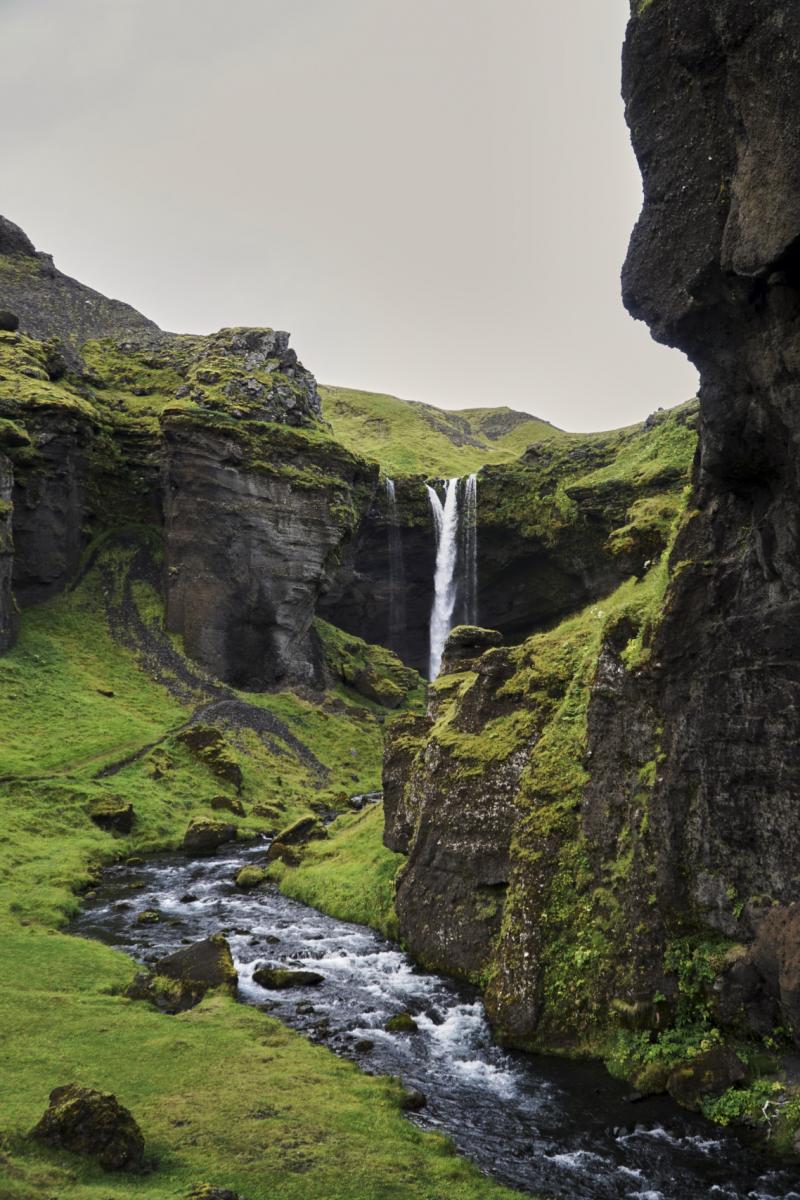
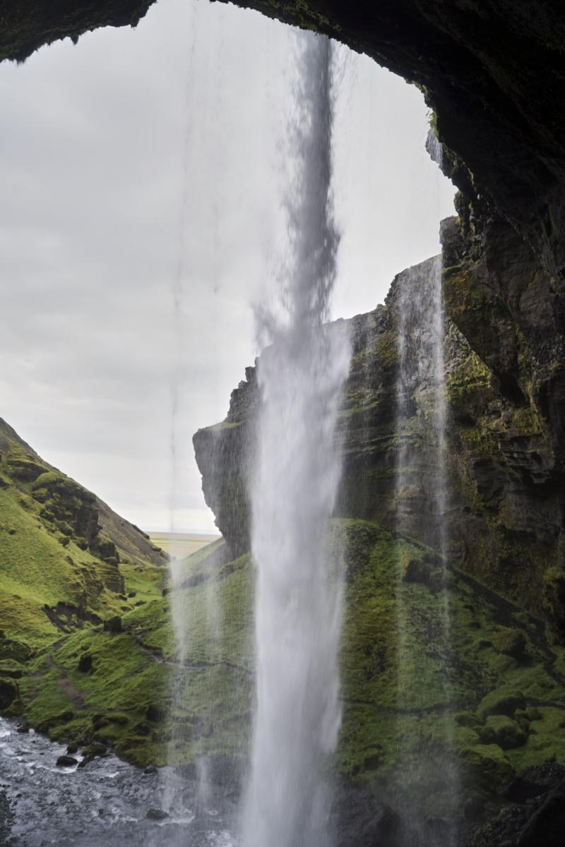
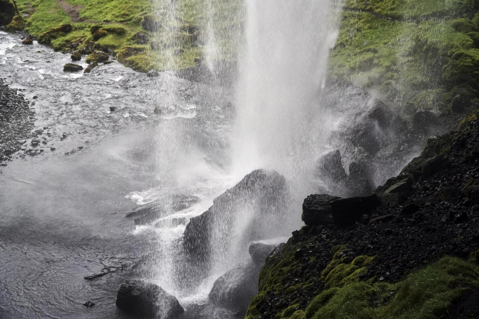
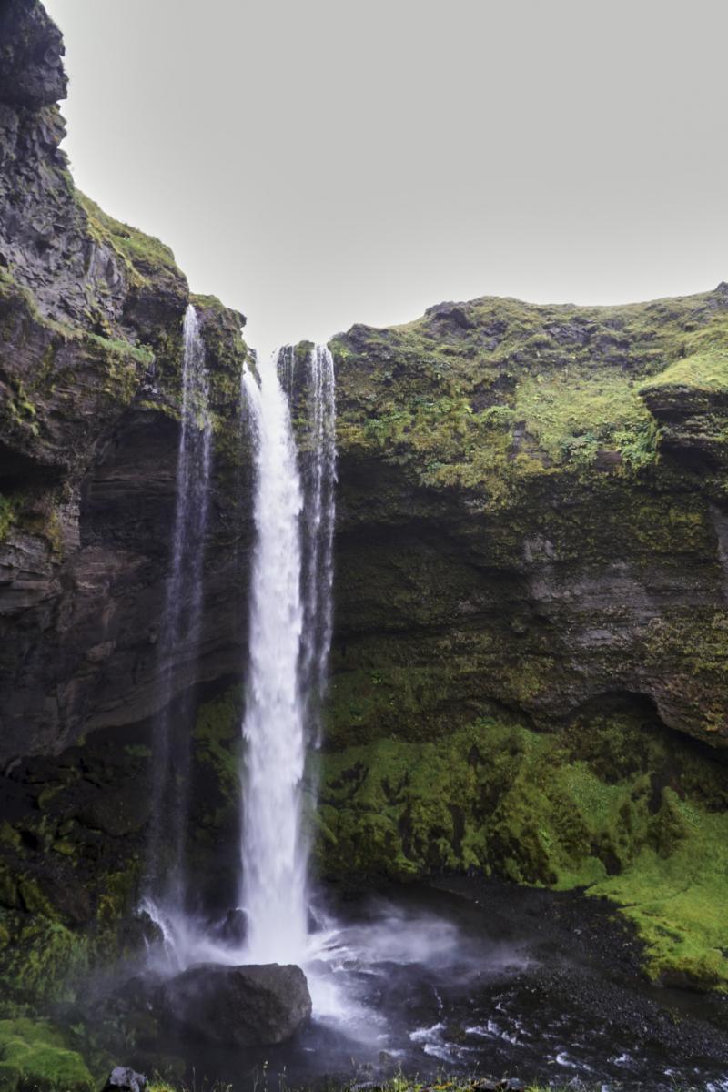
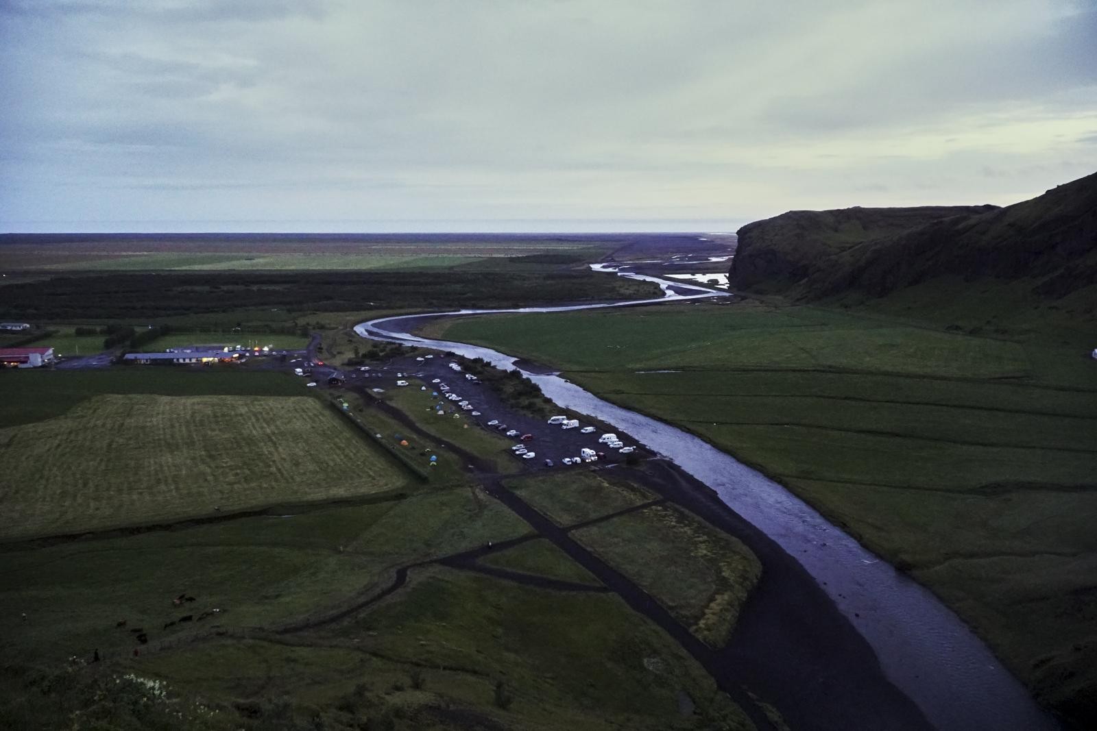
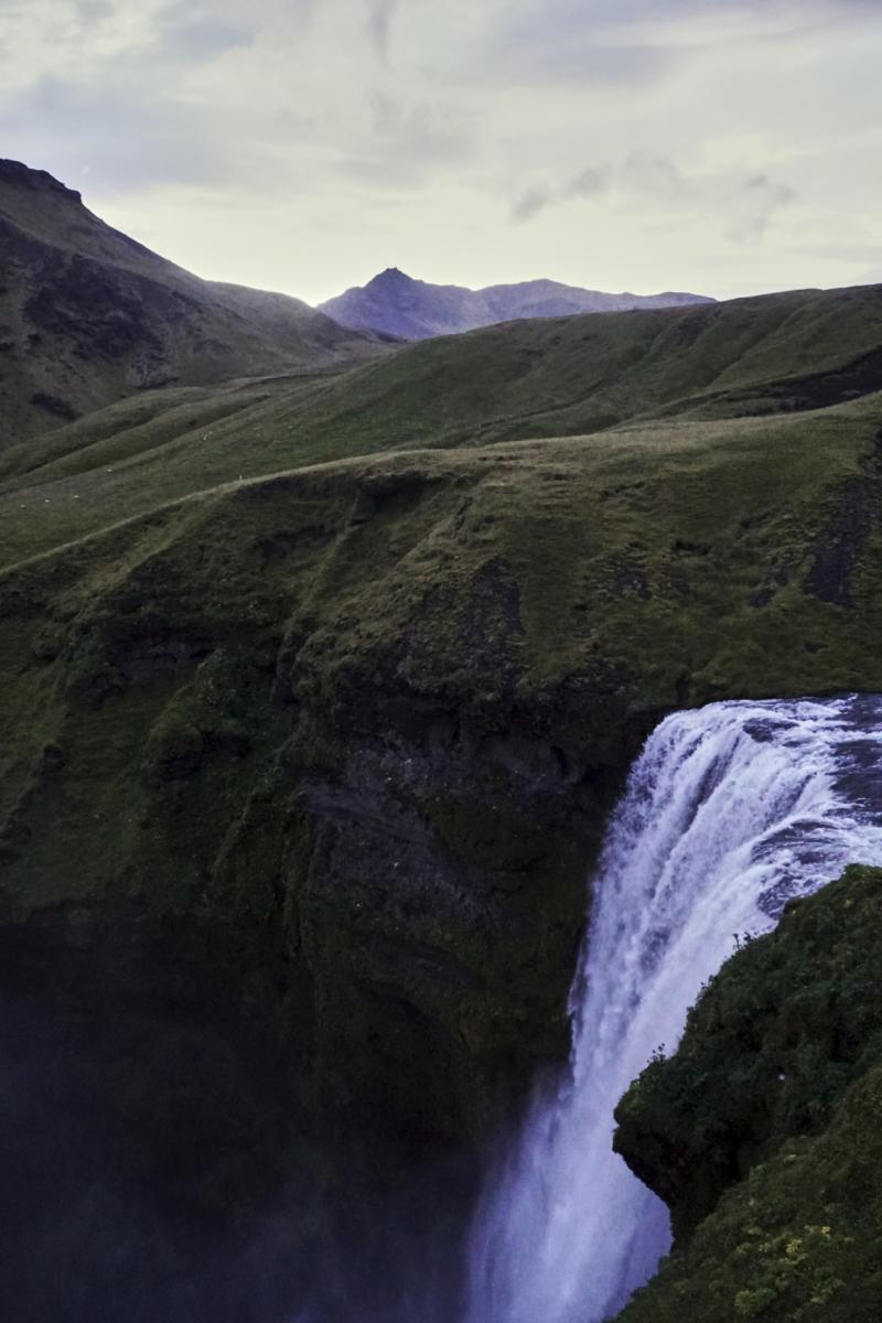
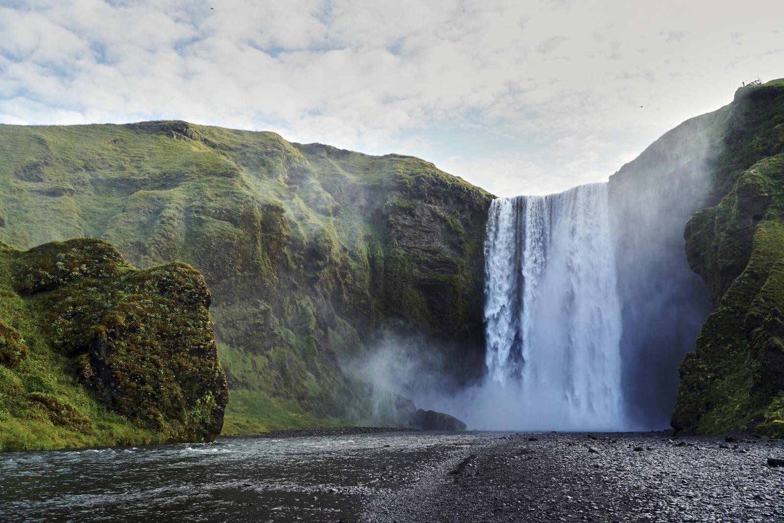
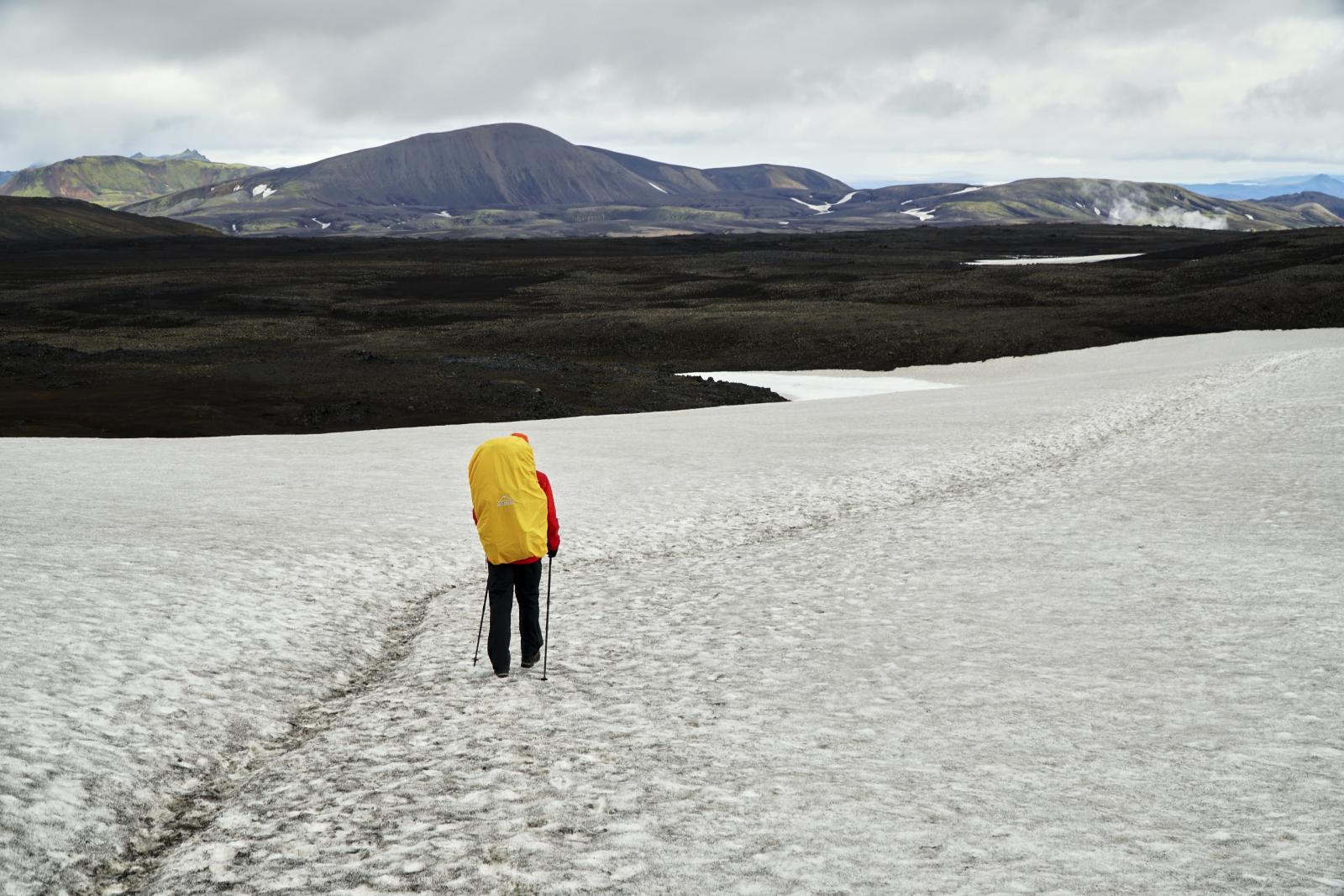
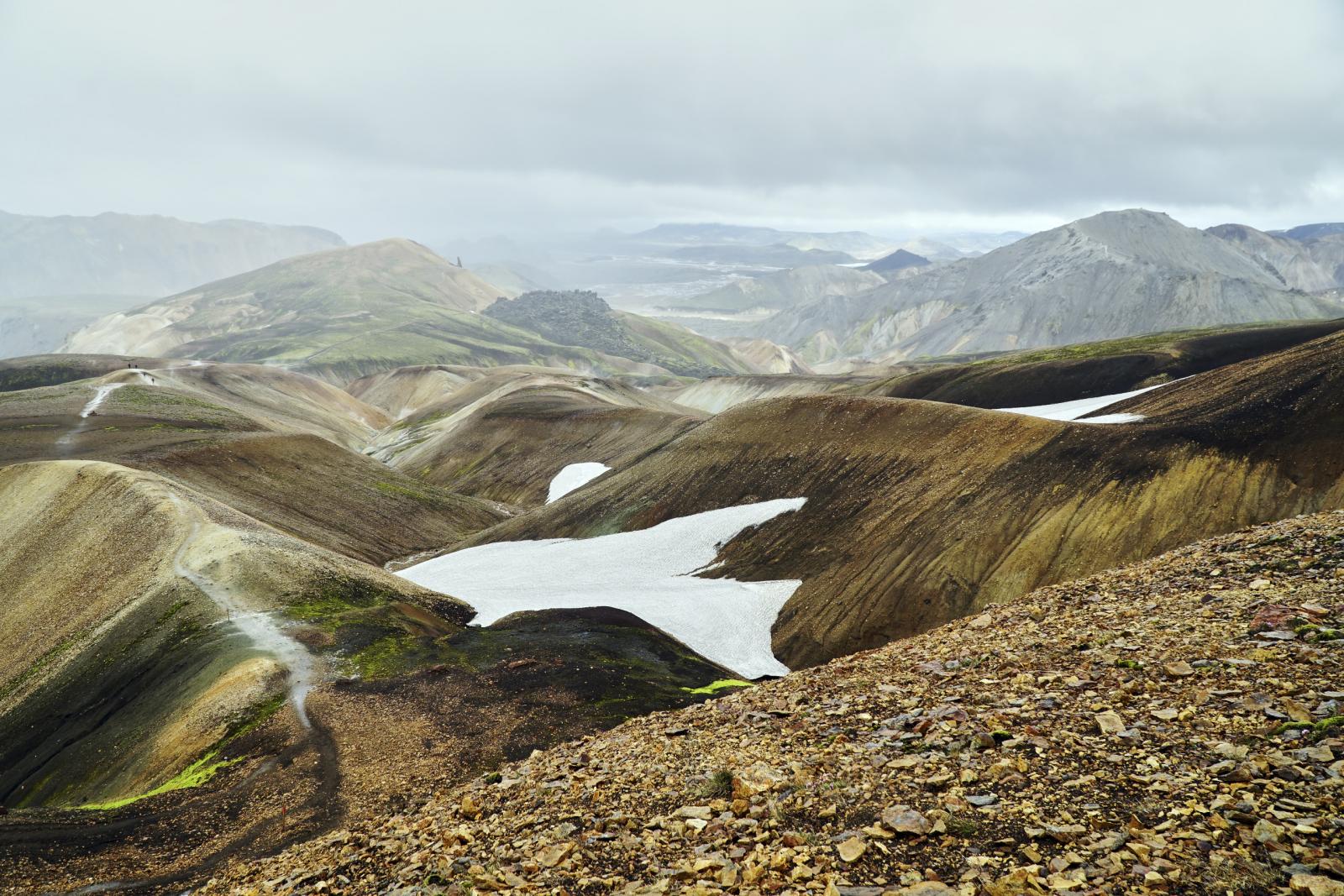
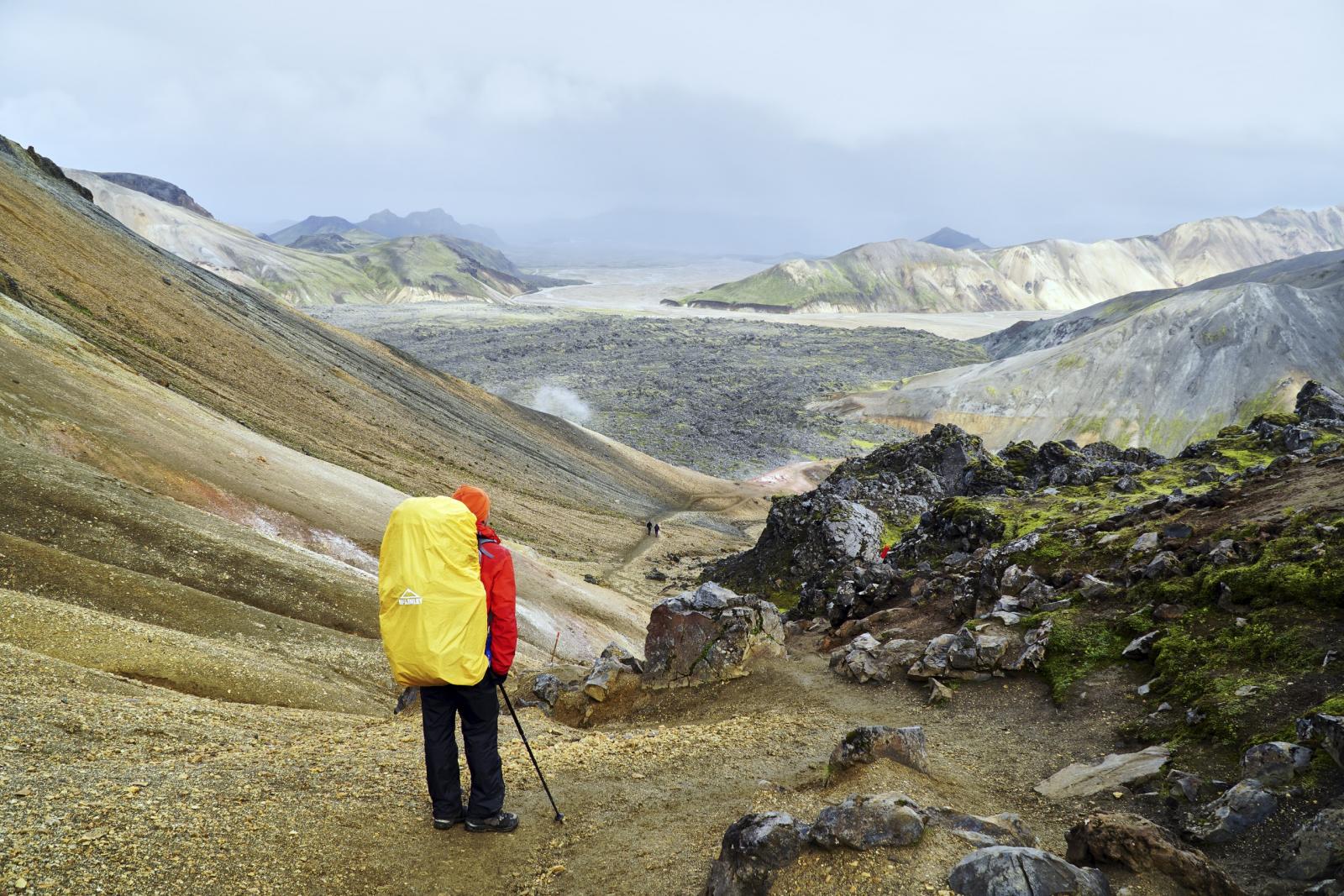
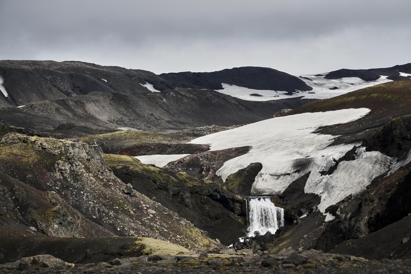
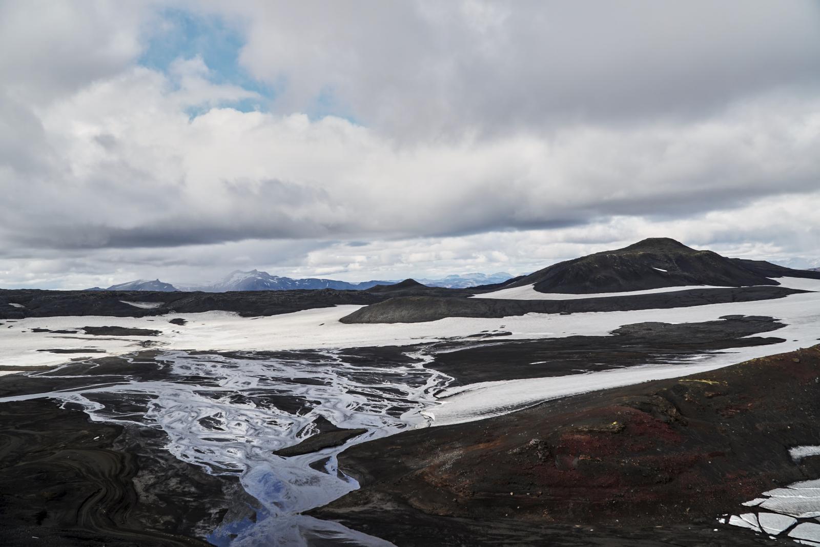
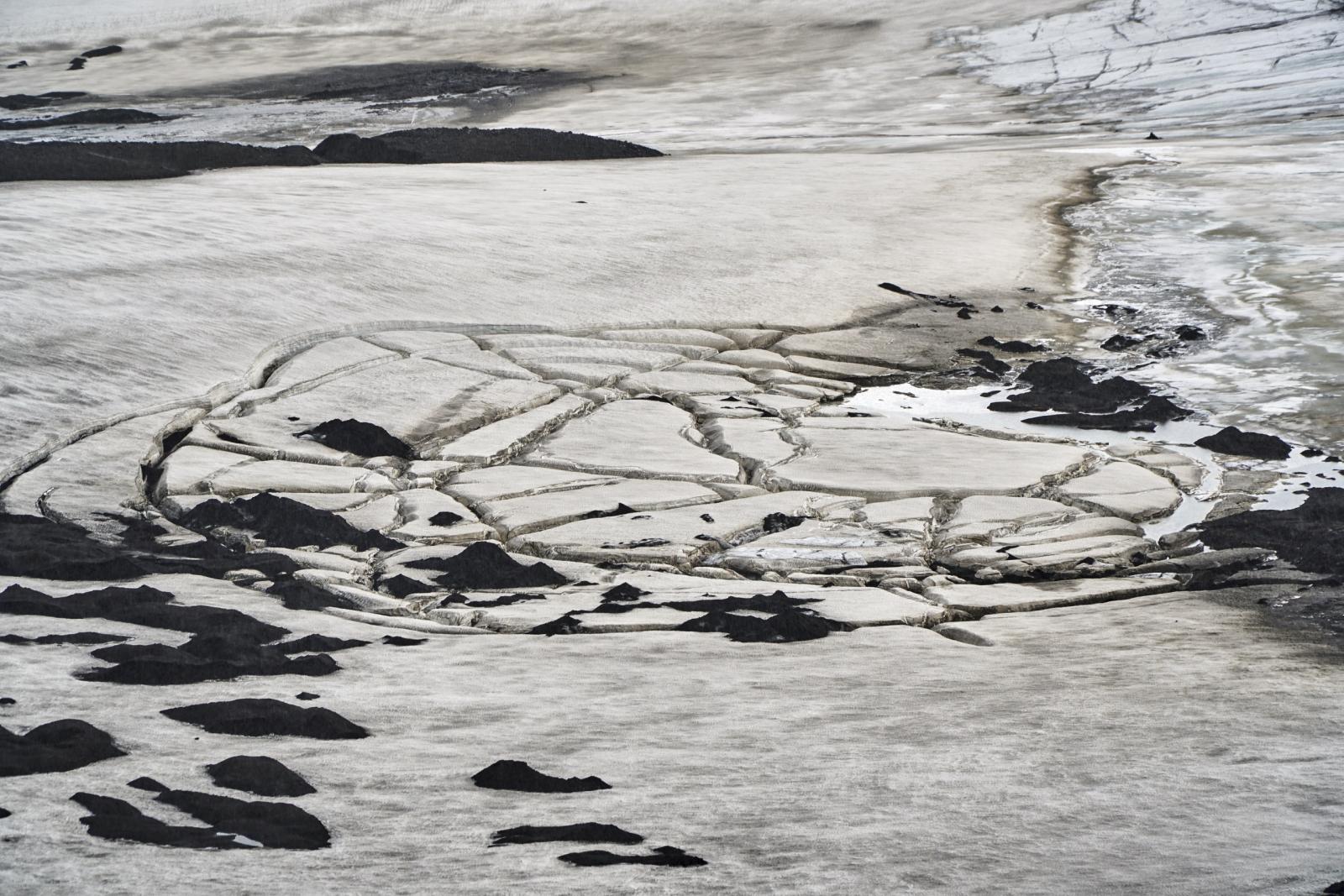
Im August 2018 sind mein Vater und den Laugavegur in Island gegangen. Ich wollte euch an meinen Eindrücken etwas teilhaben lassen. Dies wird aber ein etwas bilderlastiger Bericht. Zudem war ich zu diesem Zeitpunkt noch nicht leicht sonder schwer unterwegs. Diese Wanderung hat mich jedoch dazu bewegt mich mit UL zu beschäftigen und sich hier anzumelden, was extrem viel gebracht hat. Nach der Ankunft in Kevlavik fuhren wir mit dem Bus nach Reykjavik und deckten uns mit Gas ein und fuhren anschließend mit dem Bus nach Skogar. Der Busfahrer war sehr gesprächig und er erzählte uns einiges über isländische Geschichte, was sehr interessant war. Am Skogarfoss angekommen war wie erwartet viel los. Nachdem wir unser Zelt aufgeschlagen hatten besuchten wir den Kvernufoss einen wenig bekannten aber wunderschönen Wasserfall ca. 30min entfernt vom viel besuchten Skogarfoss. Beim Rückweg begutachteten wir noch die alten Häuser des Museums. Gegen Abend stiegen wir noch die Stufen an die Spitze des Wasserfalls und genossen die Aussicht. Als wir wieder unten ankamen waren fast alle Leute verschwunden bis auf ein paar Camper.
1 Punkt
-

Küchenkonzepte für kurze Touren
Painhunter reagierte auf immermüde für Thema
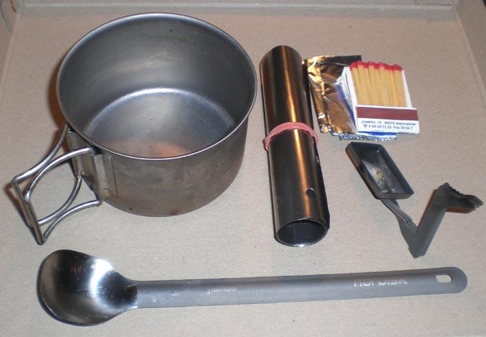
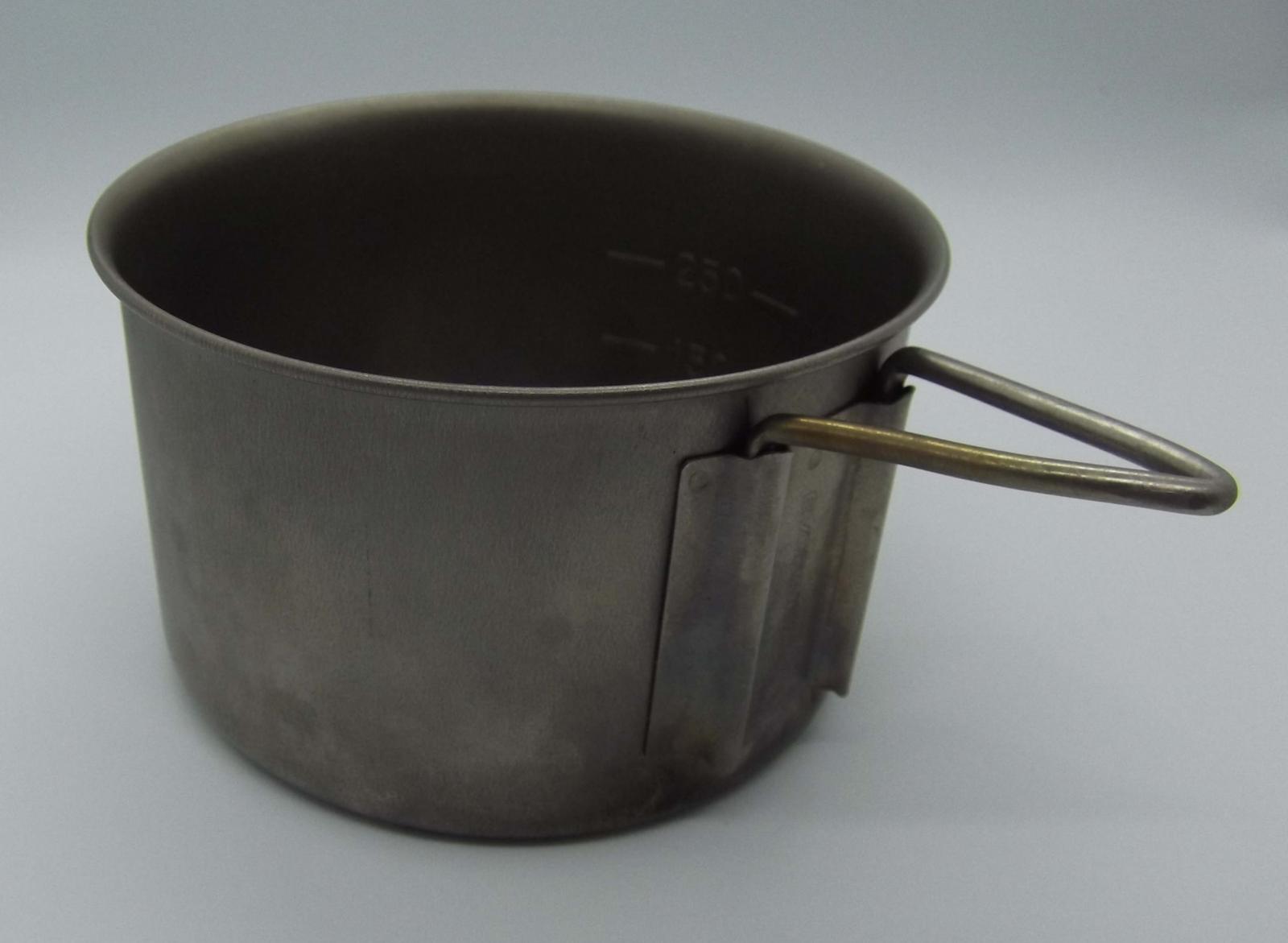
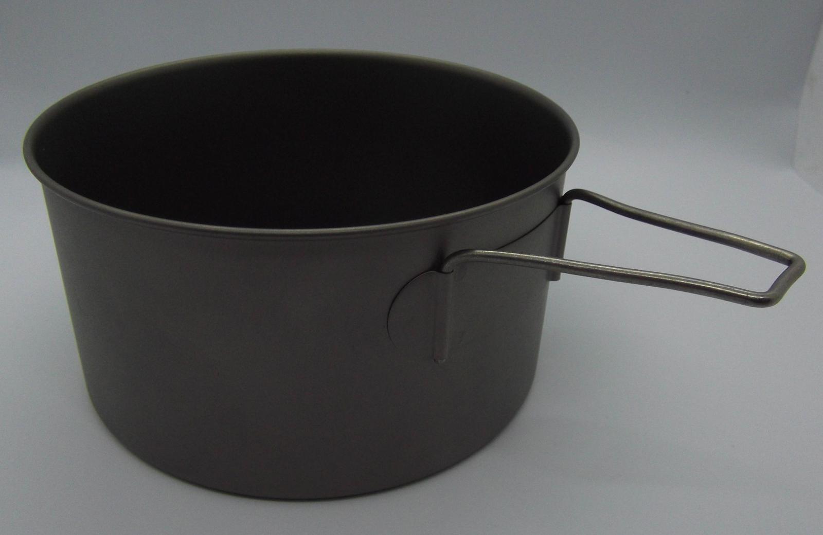
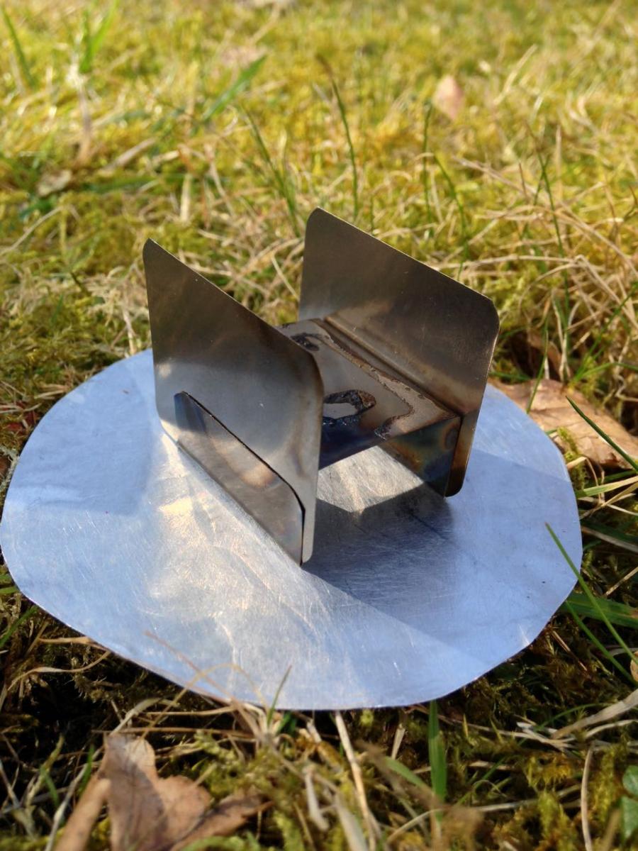
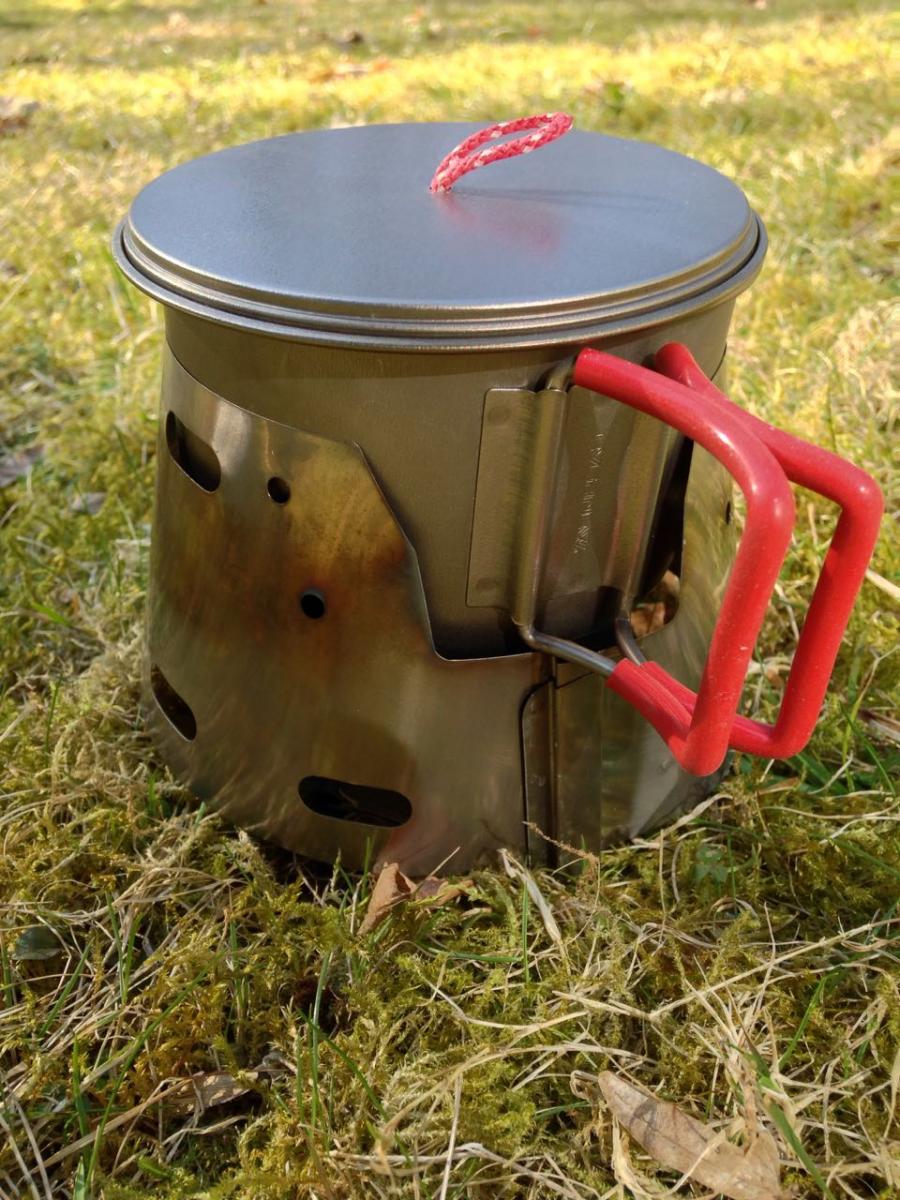
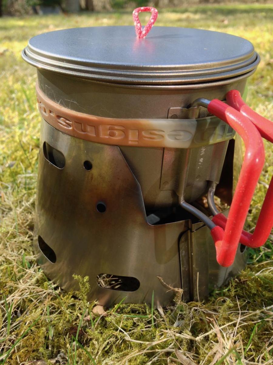
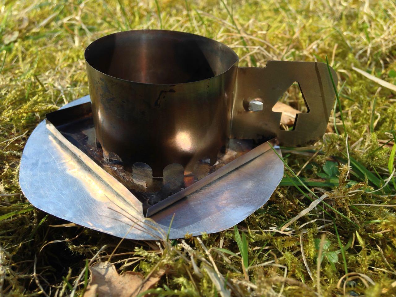
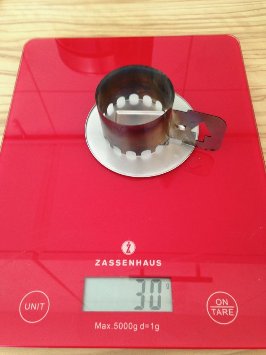
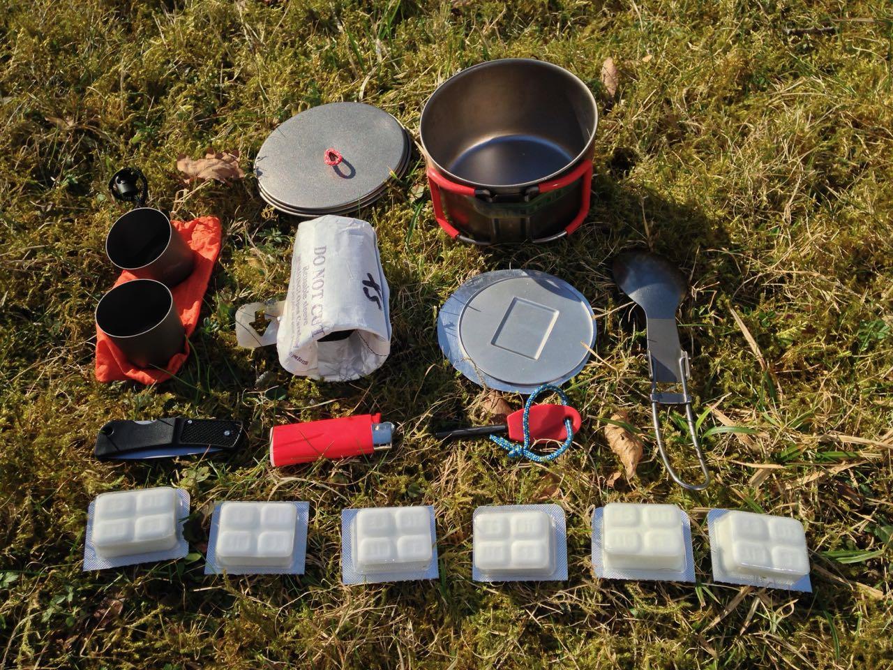
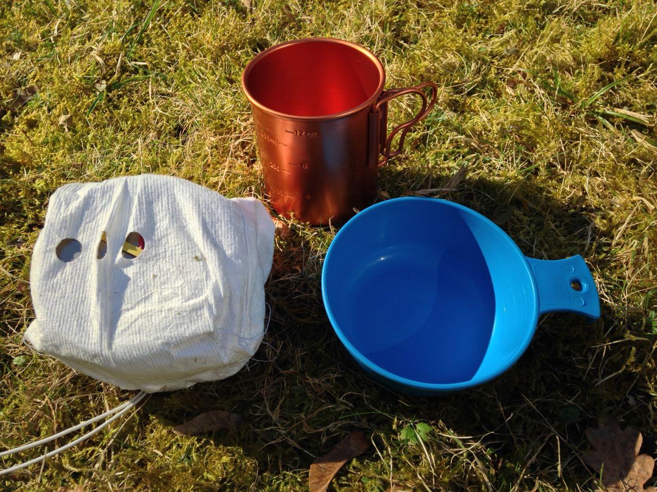
Hallo zusammen, hab nach einigem Probieren das für mich leisteste Küchenkonzept gebastelt, das gerade noch so für kürzere Touren ausreicht. Insgesamt (mit 2 nicht abgebildeten Tüten) wiegt das Ganze 98 g. Tasse 400 ml. Ist natürlich ein SchönwetterSet aber superleicht. Was haltet ihr davon und wie sehen eure SchönwetterSets aus?
1 Punkt -
Küchenkonzepte für kurze Touren
Mittagsfrost reagierte auf immermüde für Thema
an sowas batele ich gerade, ein Kegel zum zusammenstecken. Das gut daran, ich kann es mit einer normalen Schrere ausschneiden. Wenn ich was Herzeigbares hinbekomme werd ich's vorstellen.1 Punkt -
Ich mache da entweder an beiden Enden eine Falz rein, also eine nach aussen, eine nach innen, oder ich schneide eine Ritze im Abstand von so 5mm, eine von unten, eine von oben. Ob das bei einem Cone gut funktioniert, ist eine andere Frage. Für mich tut es aber auch ein Zylinder.1 Punkt
-
Ne Menge guter Ideen von euch, danke dafür, der Basteltrieb hat mich gerade wieder gepackt. @Andreas K. das mit den Laschen zum Zusammenstecken hat mich auf eine Idee gebracht. @mittagsfrost so wie du mit den Rouladennadeln mach ich es bis jetzt auch, nur mit einem Bambusstäbchen. Auf den Bildern sieht man's. Das Teil würd ich gerne weglassen im Sinne der Simplifizierung der Ausrüstung. @mosfen die Griffe kann ich abmachen. Sie halten sehr gut. Ich hab die Drahtenden zum Einhängen so lang gemacht wie die Aufnahmen, das ist sehr stabil. Leider sind es 2 Töpfe von unterschiedlichen Herstellern, deshalb kann ich nicht einen Griff für beide benutzen.1 Punkt
-
Ich nehm dazu immer solche Magnetdinger1 Punkt
-
Hallo @immermüde, ich hab mir ein ähnliches Setup zusammengestellt und den Weg dorthin hier beschrieben: https://www.ultraleicht-trekking.com/forum/topic/7822-evolution-einer-leichten-küche-teil-2/?tab=comments#comment-124348 Der erste Teil ist darin verlinkt. Deine Lösung für die Topfgriffe finde ich gut. Ziehst Du es zum Transport immer ab und hält es gut? VG, mosven1 Punkt
-

Küchenkonzepte für kurze Touren
immermüde reagierte auf Mittagsfrost für Thema
Beide Blechenden übereinanderlegen, zwei kleine Löcher im Abstand von vielleicht 5 cm reinbohren und eine Rouladennadel durch beide Löcher fädeln. So habe ich es bei einem Windschutz gemacht und bin mit der Verbindung zufrieden.1 Punkt -
@questor Es sind auf jeder viele unterwegs. Wir haben 2 Tage für den Pass gebraucht. Für den laugavegur selbst 3 Tage. Wir haben die letzten beiden Etappen zusammengefasst. Für uns haben die Etappen damals gut gepasst. Wir waren aber auch noch recht schwer unterwegs. Mit leichtem Gepäck kann man vermutlich noch Etappen zusammenlegen. Temperaturen weiß ich nicht mehr. Im Internet sind dazu auf jedenfall einige Reiseberichte zu finden. Der Weg ist immer eindeutig zu erkennen. Wasser gibt es an den Campingplätzen. Wir haben damals alles von zuhause aus mitgenommen. Es kann aber auch in Reykjavik gut eingekauft werden.1 Punkt
-
Wir haben damals einen Adapter verwendet, aber es wäre top, wenn hier gelegentlich Updates gepostet werden würden ... In dieser Ecke der Stadt haben wir damals unsere Stechkartusche gekauft: https://goo.gl/maps/JLSMkzKNLf4b1bzk91 Punkt
-
Meine Plav Erfahrungen sind fünf Jahre alt und damals gab es dort keinen Trekking- oder Bergladen. Plav selbst ist nicht riesig und in 30 min erkundet. Stechdornkartuschen sind im Balkan gar nicht selten und meist in Eisenwarenläden oder Haushaltswarengeschäften die Gaslampen oder Kocher verkaufen zu finden. Schraubkartuschen habe ich bisher im Balkan nie gesehen. Ich habe schon Spiritus in Tirana gekauft.1 Punkt
-
Ich habe mit Freunden nach einer Tour gesucht über 2 Wochen. Nach diesem tollem Bericht hat sich die Suche für uns wohl erledigt. Wirklich toll geschrieben. Danke!1 Punkt
-
Prima Bericht! Wir planen dieses Jahr Anfang Juni den PoB in Angriff zu nehmen. Die Vorfreude steigt auf jeden Fall mit jedem Planungstag Eine kurze Frage zu Plav hätte ich noch. Weiß zufällig jemand ob man dort Schraubkartuschen erwerben kann und falls ja wo? Oder geht es tatsächlich nur mit Stechkartuschen und entsprechendem Kocher/Adapter, wie man es überall liest? Besten Dank für jegliche Info in die Richtung!1 Punkt
-
Ich finde es auch klasse, dass Christian die Datei zur Verfuegung gestellt hat, aber kommt auf den Einsatzzweck an, wenn angedacht ist, den wie org an 2 steifen Plastikringen um groessere Absidenflaechen zu halten, wobei ja ordentlich Kraefte durch Wind entsteehen koeennen, wuerde ich lieber das Org-Teil aus Metall verwenden, das ist schon sehr stabil und die Loesung gefaellt mir deutlich besser als z.B. die Entsprechende von TT, hat bei mir schon so einige Naechte in Starkwind ueberlebt. @zafas komm doch zum Wintertreffen, da kommen ja so Einige aus dem koelner Raum, da kann bestimmt jemand fuer Dich die Teile bei S&P besorgen und portofrei mitbringen1 Punkt
-
Vielleicht fragst du mal bei @Christian Wagner, der hat davon mal einen Prototypen gedruckt:1 Punkt
-
Wenn Du fragst, was wirklich notwendig ist, dann wäre die Antwort: Auf dem nördlichen Teil Regenjacke und Zahnbürste, sonst nix. In den Hütten findet man alles, zum Essen und Übernachten, wenn man das Geld ausgeben will. Theoretisch würde ein Daypack reichen, um Proviant für die Etappen mitzunehmen, wo man nichts kaufen kann. Kleine Powerbank reicht für mp3-hören völlig aus, GPS braucht man nicht, Empfang hat man eh nicht. Das ist imO auch deshalb ein guter Tipp, weil 20 h Sonne im Gesicht schon ganz schön nerven können. Mit dieser Richtung habe ich auch gute Erfahrungen gemacht, außerdem gehen die meisten in der anderen Richtung.1 Punkt
-
Mein EM-Konzept ist sehr ähnlich, ergänzt durch Klapplöffel, damit der auch in den Topf passt. Ich habe allerdings die Erfahrung gemacht, dass die Effizienz wesentlich besser ist, wenn der Windschutz als Cone so gebildet, dass er nach oben enger wird und mit dem Topfrand abschließt, Material: Carbonfelt (Vorteil: auch Topflappen ) oder Titanfolie.1 Punkt
-
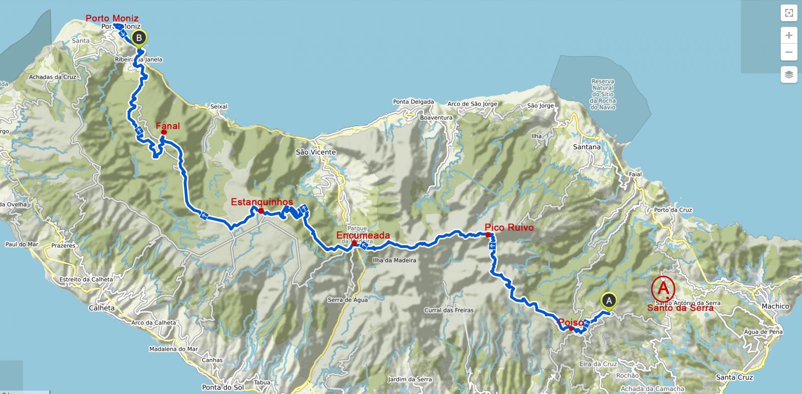
@alle - hab mich gefreut, dass so viele mitgelesen haben danke für das nette Feedback. @fool Viel Spass, es wird sicher toll: Wenn du Camps "buchen" willst, am Besten alle auf einmal - irgendwie ist die Site buggy und es "verschwinden" gern mal einzelne Camps in dem Select während der Auswahl. Oder nochmal mit nem anderen Browser probieren. Solltest du in Funchal ne Nacht bleiben wollen - ich hab in der Pension Pensao Residencial Mirasol übernachtet. Ist eine Straße oberhalb der Altstadt gelegen, nah zur Bushaltestelle. Ist zwar etwas schrabbelig, kost aber auch nur 33 Euro ohne Frühstück und hat Charme. Die Betreiber sind super nett gewesen. Außerdem kann ich das Café Barreirinha Bar Café empfehlen, östlich der Kirche in der Altstadt (also noch etwas östlicher der - wie ich finde - etwas nervigen "Restaurant-Meile"). War ein nettes Publikum, man kann superschön zum Sonnenuntergang hin , weil direkt oberhalb vom Meer. Viele sitzen auch lässig auf dem Mäuerchen... @roli Ich bin im Prinzip die "gemachte Tour von Taeve-Supertramp" gegangen. Ich glaube ab und zu ist er die Straße gegangen, wo ich den Waldweg nahm. Hatte mich eher an einzelne Tracks von @ChristianB (danke nochmal) gehalten (hab selbst nicht aufgezeichnet). Aber zur Orientierung (bei Santo da Serra gestartet): Glaub du bist über Rabacal gegangen? Dort war ich nicht.
1 Punkt
-
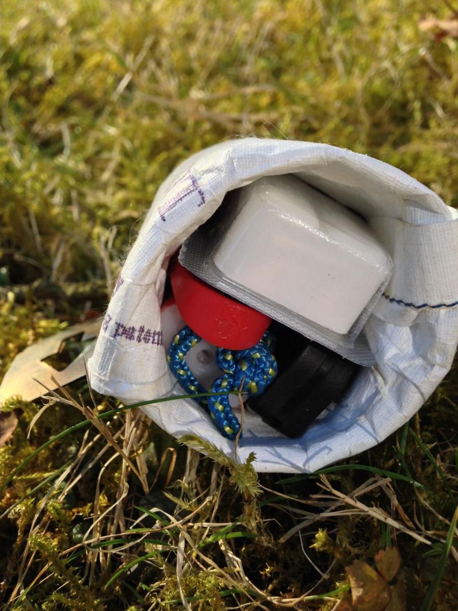
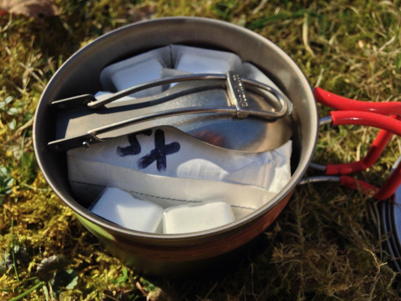
Was habt Ihr im 1. Hilfeset (für kurze und für lange Touren)
ALF reagierte auf MeisterGrimbart für Thema
Ich bin immer versucht, viel Erste-Hilfe-Zeug einzupacken, lasse es aber dann doch bleiben. Ich habe mal, vor vielen Jahren, für's Rote Kreuz San-Dienst bei Schützenfesten, Altstadtfesten, Theatervorstellungen etc. geleistet. Da gab es damals die tradtionelle "San-Tasche". Später hatten wir dann eigentlich nur noch eine Beatmungsmaske, eine Rettungsdecke und ein Paar Handschuhe in den Jackentaschen. Vielleicht noch ein Dreiecktuch und eine sterile Kompresse. Selbst da war mehr eigentlich unnötig direkt dabeizuhaben. Wichtig ist Wissen. Wie lagere ich bei welchem Problem, das ist wichtig. Wann binde ich ab (war damals noch Gegenstand) und wann reicht Druck? etc. Wann muß ich weitere Hilfe dazuholen, und was geht wieder vorbei? Da kommt die regelmäßige Wiederholung von Erste-Hilfe-Kursen in's Spiel. Gibt's bei der Arbeit umsonst, wenn man sich als Ersthelfer nach UVV zur Verfügung stellt. Ich habe in Wald und Feld (wenn ich Gepäck habe) eigentlich nur Sachen mit, mit denen ich Fußblasen und vielleicht mal einen geschnittenen Finger regeln kann. Also Pflaster und Heftpflaster, etwas zum Desinfizieren. Nadel und Faden sind im Reparaturkit. Schmerztabletten, etwas gegen Durchfall, Allergie (Anaphylaxis), Sodbrennen (weil einem das die Tour versauen kann und ich dazu neige). Ein Bandana ist sowieso dabei, kann als Dreieckstuch zum Festlegen, als Druckverband oder zum Abbinden dienen. Mehr eigentlich nicht. Oh - und ein SPOT Gen3, je nachdem, selbst in der Zivilisation. Ich war mal im Wald, gar nicht weit von zuhause, und da hätte der mir viel Unbequemlichkeit erspart, als ich aus einem Bereich ohne Handyabdeckung unter erschwerten Bedingungen nach Hause kommen mußte. Das will ich mir für die Zukunft eher ersparen, einmal reicht. Und man wird nicht jünger. Da hätte mir aber auch ein 3-Kilo Erste-Hilfe-Set nichts genützt.1 Punkt -
Interessante Tarpkonfigurationen
wilbo reagierte auf Christian Wagner für Thema
Mal was für bikepacker...1 Punkt -
Tag 7: Nach Porto Moniz Trotz der feucht-kalten Umgebung habe ich irgendwann tief und fest geschlafen. Als ich aufwache, regnet es wieder oder es tropft der Baum… das eine vom andern ist schwer zu unterscheiden. Es ist auch immer noch windig… Ich drücke ganz fest die Augen zu. Nicht aufmachen, denke ich. In meiner embryonalen Schlafhaltung will ich mich einfach nicht bewegen, gerade ist mir so schön warm. Zumal es links und rechts des Sacks etwas nass ist, vor allem rechts am Eingang wo das Mesh ist. Ich habe es abends schon bemerkt, aber mich bemüht, mich davon nicht verrückt machen zu lassen. Nützt ja eh nix. Es ist zumindest über Nacht nicht viel mehr geworden. Keine Ahnung, woran es liegt. Von dem nicht ordentlich straffen Mesh, das auch nicht 100% senkrecht ausgerichtet ist. Dies könnte dazu führen, dass sich die Luftfeuchtigkeit daran verfängt und nach innen tropft? Der Bathtube-Boden (oder wie heißt das?) ist nicht ordentlich aufgerichtet, dadurch kommt durch den Reißverschluss unten Wasser rein? Glaube ich aber eher nicht. Abgedichtet ist es überall ordentlich… Am liebsten wär mir natürlich, es läge an den Umständen… Wenn die Luft so voller Wasser ist, ist es ja kein Wunder, dass sich die Feuchtigkeit irgendwo absetzt… rede ich mir zumindest ein. Trotzdem, nächstes mal ordentlicher und mehr in Ruhe aufbauen, egal wieviel Wind. Irgendwann klingt es draußen etwas besser und ich schaue auf die Uhr: So langsam kann ich mal zusammenpacken. Will unbedingt aus diesem anstrengenden Nebel-Wind-Wasser-Wetter raus - Immer noch sehe ich im Licht meiner Lampe die Luftfeuchtigkeit. Als ich soweit bin, dass das Zelt dran ist (so früh war ich noch nie), ist es noch stockdunkel. Dichtester Nebel. Also nochmal ins Zelt und etwas warten. Dämmern sollte es schon. Viertel vor 8 wage ich es. Zur Not kann ich in dem Unterstand noch etwas warten. Ich laufe los, es regnet nicht, aber Nebel nach wie vor. Ich denke (hoffe), mit jedem Meter Abstieg wird es heller, na ja, ein wenig. Es geht lange an einer Levada entlang durch einen Wald, das bedeutet, entspanntes Gehen. Irgendwann ist Ribeira ausgeschildert und es geht durch den Wald einen Weg, der aus mit Holzbohlen angedeutete Stufen besteht - und immer wieder durch Matsch, einmal sinke ich ganz schön tief ein, Mist. Als ich aus dem Wald rauskomme, eröffnet sich der Blick auf das Meer und etwa blauer Himmel. Hach wie schön… Und ich sehe wieder erste Anzeichen dörflicher Strukturen. Bis Porto Moniz geht es aber noch auf steilen Asphalt-Wege, die in der Mitte winzige Stufen haben, das soll das Gehen wohl erleichtern. Als ich nach Ribeira de Janela runter laufe, sehe ich von oben den Campingplatz, ein Zelt und eine Person ist zu sehen, sie hängt gerade ihr Handtuch in die Sonne. Ist es Antje? - hm, nicht sicher, aber eindeutig ein UL-Zelt (milchig-halbtransparent weiß…). Tja, sollte ich da jetzt auch stehen, in grün? Aber mal ehrlich.., so zwischen den Autostrassen... so nice ist der Platz nu auch wieder nicht - zumindest versuche ich so mir meine Hotelnacht zu legitimieren. Schade, hätte gern mit ihr etwas geplaudert, aber vielleicht sehe ich sie ja morgen nochmal. Ehrlich gesagt, freue ich mich auf eine heiße Dusche und ein profanes Hotel-Frühstück bis in die Puppen. Im Hotel folgen Tätigkeiten in der Reihenfolge: 1. Heiß duschen, 2. Klamotten waschen (irgendwann ist auch Merino durch. Müffelt mittlerweile alles ziemlich…). 3. Zelt und Quilt trocknen. 4. ESSEN... Die restlichen Tage… Ich beschloss (in Fanal?), die restlichen, verbleibenden 2 oder 3 Tage relaxt und easy wieder Richtung Funchal zu zuckeln (mit Bus und zu Fuß). Eine Nacht in einem abgelegenen Casa Rural (Langasthof) oberhalb der Küste mit Blick auf das Meer, von da aus gehe ich nochmal ein Stück die Levada Nova - das ist jedoch relativ unspektakulär und führt zum Teil durch besiedeltes Gebiet, aber gehört vielleicht auch dazu. In Prazeres (Regenwetter), stolpert Frau Antje plötzlich nochmal in das charmanten, winzigen Café, in dem ich mich aufwärme, und das von jungen Leuten mit viel Liebe und architektonischem Händchen - sicher in Eigenarbeit - ausgebaut wurde. Hoffentlich kommt hier in diesem abgelegenen Nest häufiger mal jemand vorbei. Wir tauschen uns über die letzten Nächte und Zeltplätze aus (sie hat erst ca. 3 km nach Fanal gezeltet, auch wenn mir nicht klar ist, wo da ein Platz gewesen sein soll - ich hatte am nächsten Tag geguckt. Sie sagt was von Picknickbänken… hm, könnte sein, dass ich was gesehen hab. Dort wars wohl angenehmer) und ich erblasse etwas, wie sie unterwegs ist und wie easy sie Plätze für das Zelt findet (das Cuben-Zelt war tatsächlich ihres). Versuche mir noch was abzugucken (sie eruiert wohl viel über die Karte). Irgendwie höre ich zwischendurch raus, dass sie auch als Trekking-Guide im Himalaya arbeitet? Na dann… In den lauschigen Tagen schaue ich viel aufs Meer. Genieße auch das, hatte ich auch lange nicht mehr, ich könnte nun die Runde auch wieder von vorn beginnen. Wie schnell ist die ein oder andere „Strapaze“ vergessen. Schon nach dem Tag in Moniz war ich eigentlich wieder fit, ein Pausentag hätte gereicht - das hätte ich in Fanal nicht gedacht. An der Küste scheint die Sonne und oben in den Bergen hängen schwarze Wolken, insofern ist es vielleicht auch gut so wie es ist… Aber fürs nächste Mal nehme ich diese Erkenntnis mit. Als ich die Tageswanderer im Hotel sehe, denke ich: Was für eine tolle Tour hast du gemacht und ich wollte nicht tauschen. Frau Antje war noch 1 weitere Woche unterwegs. Wieder in Funchal, letzter Abend, Sundowner in einer netten Bar etwas oberhalb...
1 Punkt
-
Küchenkonzepte für kurze Touren
LAUFBURSCHE reagierte auf immermüde für Thema
Hallo Freunde der leichten Küche, krame mal den alten Thread wieder aus. Ich hatte wieder Bastelstunde und wollte Mal versuchen ob die Küche noch leichter geht. Ursprünglich waren es 100g. Die Griffe des Topfes mussten dran glauben, also abmontiert und umgefummelt. Den Löffel hab ich auch noch gekürzt und den Windschutz ein Stück abgeschnitten. Jetzt bin ich bei 73g. Topf 400ml 39g, Löffel 7g, Windschutz 13g, Brenner 13g, Alufolie 1g. Mit meinem 900ml Topf hab ich das Gleiche gemacht. Wiegt jetzt ohne Deckel anstatt 77g noch 67g. Lässt sich zwar nicht mehr so hübsch stapeln, aber was solls. viele Grüße an alle von immermüde
1 Punkt -
Torwald - Einpersonenzelt, almost quick&dirty
bieber1 reagierte auf Christian Wagner für Thema
Habe 20d Silnylon gekauft. Es soll ein Torwald mit Tor werden. Ob mit oder ohne Moskitonetz, mit oder ohne Boden usw., da bin ich noch am mit mir hadern. Außerdem steht noch eine Zweipersonenpyramide an. Wir werden sehen... Ich sage euch jedenfalls Bescheid wenn es was neues gibt. LG, Christian1 Punkt -
TAR hat still und heimlich eine xlite in wide aber mit regulärer Länge raus gebracht. 430 statt 460g sind allerdings erschreckend wenig Unterschied. https://www.thermarest.com/sleeping-pads/fast-and-light/neoair-xlite-sleeping-pad/neoair-xlite.html1 Punkt
-

Was lest Ihr gerade?
Murx reagierte auf Pfotentrail für Thema
Habe grade „in eisige Höhen“ von Jon Krakauer angefangen. Suuuuuperspannend! Daher absolute Lese-Empfehlung wenn’s auch was bergsteigerisches sein darf1 Punkt -
Nach einer Mittagpause ging es zunächst über ein Schneefeld. Wir kamen auch noch an einigen dampfenden Tümpeln vorbei. Dann ging es noch durch eine bunte Landschaft bis zu diesem Punkt von wo aus man das Lavafeld vor Landmannalaugar gut überblicken konnte. Dieses Lavafeld mussten wir in den nächsten Tagen noch mehrmals auf dem Rückweg unserer Tageswanderung durchqueren. Die Berge in Landmannalaugaer sind allesamt unterschiedlich bunt und wirklich beeindruckend.
1 Punkt
-
Nach etwas über der Hälfe der Strecke oder 2/3 ich weiß es leider nicht mehr genau ändert sich die Landschaft und es wird kark und es ist auch der erste Schnee zu sehen. An einen Gletscherauslauf haben wir dann noch unsere Wasservorräte aufgefüllt, da es oben kein Wasser geben sollte (jeweil 4 Liter. Das würde ich heute nicht mehr machen). Mit dem zusätzlichen Wasser wurde der letzte Anstieg hinauf zur Qual. Ich hatte definitiv die Grenze des tragbaren überschritten. Aber vielleicht hatte es ja auch was gutes. Mit so viel gewicht werde ich devinitiv nicht mehr laufen. Oben angekommen begrüßte uns der Hüttenwirt. Ein deutscher Rentner, der die Betreuung der Hütte für ein paar Wochen übernommen hatte. Er erzählte uns das wir wenn wir Zelten wollen wieder etwas zurück gehen müssten zu einer Ebene, da ganz oben bei der Hütte die Winde zu stark seien. Wir könnten jedoch auch auf der Hütte übernachten, da er nur zwei Reservierungen hätte. Wir entschlossen uns in der Hütte zu bleiben. Nach einer Pause waren wir wieder erholt und machten noch einen Spaziergang entlag dies Kamms. Beim Abenessen gab uns Uwe auch noch einen Tipp für eine schöne Wanderung zu einem Aussichtsberg im Þórsmörk Tal.
1 Punkt
-
UL und immer leichter und leichter – wozu?
noodles reagierte auf Painhunter für Thema
Ich finds einfach geil wie schon hier einmal geschrieben, die Challenge gegen mich selber. Wie weit kann ich gehen? Was ist möglich? Du weißt es erst wenn du die Grenze überschritten hast! Ich mag es einfach mich in ein Thema reinzufuchsen und mit dem Wissen und der Neugierde daran zu wachsen, Erfahrungen zu sammeln um es dann auf einer Tour ins praktische Umzusetzen. Und ich mag auch die Challenge gegen andere. Wenn ich wie jetzt am Wochenende mit mehreren unterwegs bin möchte ich verflucht den leichtesten Rucksack haben. Einfach für mich um zu sehen was so geht. Wenn das dann nicht der Fall ist okay, zeig mir dein Gear und beim nächsten mal mach ich dich platt! Und natürlich...desdo weniger Gewicht desdo mehr kann ich die Tour genießen und desdo mehr ich die Tour genießen kann desdo mehr Spaß habe ich, und desdo mehr Spaß ich habe desdo weiter kann ich laufen und desdo weiter ich laufe desdo geiler isses und wessns so richtig geil ist kann ich perfekt vom Alltag abschalten und wenn ich gut abschalten kann bin ich danach wieder leistungsfähiger und wenn ich leistungsfähiger bin weil entspannt und frei von negativen Emotionen gehts mir seelisch gut. Und wenns mir seelisch gut geh ist das Leben einfach ein Zuckerschlecken und wenn...you know.... Mann UL is amfoch goil!1 Punkt -

Prototyp eines Ankerhaken mit Leinenspanner
lampenschirm reagierte auf schwyzi für Thema
Völlig OT, aber der Titel der Datei hat's mir so angetan.. "Spannerhacken" klingt wie geifernden, durch Ferngläser in Fenster glotzenden Männern eins überziehen Sorry, hatte sofort Kopfkino1 Punkt -
[AL, MNE] Peaks of the Balkans Trail 2019
_schlaefer reagierte auf sja für Thema
Mi 24.07.2019 Theth Ich frühstücke mit den StudentInnen, die ich gestern Abend beim Essen kennengelernt habe, ein Österreicher Pärchen und eine Kanadierin auf Europa-Tour. Alle wollen nach Valbona heute. Ich werde wohl zum Wasserfall gehen, vielleicht noch weiter zum Syri i kalter (wieder ein „blaues Auge“). Bis zum Wasserfall gehts ganz gemütlich. Die Kombination der beiden Touren ist allerdings nicht so ne gute Idee. Man muss zum Syri i Kalter sehr, sehr lange am Fluss entlang gehen. Auf dem Weg durch Das Tal, durch die trockenen Bachbetten brutzelt die Sonne extrem und es zieht sich ewig in die Länge Freue mich, als ich endlich eine Bar sehe und was kaltes zu trinken kriege. Mir reichts für heute. Der Rückweg geht schneller, auf dem Weg fotografiere ich noch ein paar der etwas morschen oder speziellen Brücken. Als ich am Abend in Theth reinlaufe, sehe ich Schafe auf dem Weg nach Hause den Fluss queren und den abendlichen Kuh-nach-Hause-Abtrieb. Do 25.07.2019 Theth - Shkodra Die Heimreise steht langsam an. Heut fahre ich mit dem Mini-Bus wieder nach Shkodra. Eigentlich nicht viel Programm, aber die Fahrt wird wieder zu einem kleinen Ereignis. Ich werde pünktlich um 12h abgeholt, denke, dass wir noch das ein oder andere Gästehaus abklappern und dann straight nach Shkodra fahren. Nix da. Erst mal werden noch 2 oder 3 Leute abgeladen, ok, dann werden aber erstmal noch Waren oder was auch immer ausgeliefert. Fühle mich wie in einer modernen Postkutsche: Brot, Tomaten, Gasflasche wird hier und da verteilt. Und vor allem mit JEDEM, wirklich JEDEM, dem der Fahrer begegnet, wird ein Schwätzchen gehalten (natürlich mehr Männer als Frauen). So zieht sich das ewig hin. Irgendwann sammelt er noch ein paar Leute ein (unter anderem nimmt er auch ältere Einheimische für ein paar hundert Meter mit) und insgesamt tuckern wir 1h durch den kleinen Ort, ehe wir ihn verlassen. Ich werde schier wahnsinnig, weiß ich doch, dass wir noch ne echt anstrengende Fahrt über extrem schlechte Serpentinen-Straßen über die Berge vor uns haben. Auch als er den Ort verlassen hat, quatscht er wieder mit jedem albanischen Autofahrer, der uns entgegen kommt. Eigentlich aber ganz nett, mit der Zeit wird mir klar, dass das hier eben so ist, und diese Gelassenheit ist natürlich auch superschön. Mein Flieger geht eh erst morgen und in Shkodra hab ich eh nix mehr weiter vor. Fr 26.07.2019 Die Nacht habe ich wieder in meinem Lieblingshotel Kaduka verbracht, das ich schon von der Anreise kenne. Am Vorabend hatte ich noch nach dem Bus nach Podgorica gefragt, die nette Frau wusste aber von meinem angepeilten 7h-Bus nichts (hatte ich aus dem Internet), in ihrem Fahrplan gibts nur einen um 10h. Ich fliege erst am Nachmittag, aber sicher ist sicher. Will schon versuchen, den um 7h zu kriegen. Bekomme statt Frühstück das gleiche Lunchpaket wie am ersten Tag und los geht s zur Bushaltestelle. Nach ersten Unsicherheiten, wo ich warten soll (ich bin scheinbar die einzige Person), kommt ein Mann auf mich zu und sagt mir, der Bus würde um 7:30h fahren, er zeigt mir wo ich warten soll. Während ich warte, kriege ich von irgend nem Typ eine Angebot für eine Fahrt nach Podgorica, lehne aber ab. Um kurz vor 8h ruft der Typ, der mir die Haltestelle gezeigt hat, „seinen Kollegen“ an, wie er sagt. Er vermittelt mir, der Mini-Bus käme in 10min. 15min später kommt tatsächlich ein Mini-Bus. Zwar ne andere Firma, wie ich dachte, aber egal. Ist voller Leute und fährt nach Podgorica. 1min später kommt ein noch kleinerer Mini-Bus, sitzen auch Leute drin, sieht aber nicht so offiziell aus. Der Fahrer von Mini-Bus 1 sagt mir, ich solle dort mitfahren, warum auch immer. Kommt mir etwas seltsam vor, aber da ja da auch Leute drin sitzen, mache ich das einfach mal. Muss etwas weniger für das Ticket bezahlen, aber immerhin bekomme ich eins, das beruhigt mich etwas. Ein seltsamer Mann, der etwas alkoholisiert duftet, macht mir seltsame Zeichen und Gesten, keine Ahnung was er meint. Habe ich nun einen super Deal gemacht? Hm, der gute Mann wird die ganze Zeit neben mir vorne sitzen... Der Bus ist voll. Dann streitet sich unser Fahrer erstmal ne halbe Stunde mit nem anderen Busfahrer, um 8:30h gehts dann los. Gut, dass ich es nicht eilig habe, 15min später wird ein Hotel angesteuert. Ich denke, da wird vielleicht noch jemand abgeholt, warum auch immer…, aber nein, hier wird erstmal eingekehrt und ein Café getrunken. Okay. Ich latsche den Insassen meines Mini-Mini-Busses einfach hinterher und setze mich mit an denselben Tisch, da stellt sich heraus, dass fast alle aus dem Mini-Mini-Bus eine Familie sind, (der Typ neben mir jedoch nicht). Sie fahren eine Woche ans Meer (der Bus fährt anscheinend weiter ans Meer). Die 3-Generationen-Familie, in die ich mich ausversehen eingezeckt habe, ist supernett, total entspannt drauf und ich werde sofort auf den Café eingeladen.. Es gibt auf der eigentlich 2-stündigen Fahrt noch die ein oder andere weitere Pause, insbesondere natürlich am Grenzübergang, hier wechselt auch der Fahrer und um 10:20h kommen wir in Podgorica an. Eigentlich will ich da noch ein wenig rumlaufen, aber so richtig weiß ich nicht wohin und es ist hier auch sehr heiß. Ich esse noch ne Kleinigkeit und fahre dann relativ bald zum Flughafen. Der Flug zurück nach Deutschland - alles relativ unproblematisch, wieder über Warschau. Fazit: Es war eine tolle Tour und ich will auf jeden Fall nochmal den Rest der Runde nachholen. Wer etwas ambitionierter ist, kann bestimmt noch den ein oder anderen Peak mit einbauen. Aber auch so, fand ich die Etappen sehr abwechslungsreich. Man kann die Tour komplett ohne Zelt machen, aber selbst wer ein Zelt mitnehmen will, dem empfehle ich trotzdem hin und wieder bei den Leuten zu übernachten, insbesondere in Ceremi oder Doberdol. Den Leuten kommt was zu Gute und es ist schön, näher mitzukriegen, wie sie so leben.
1 Punkt -
So, 14.07.2019 - Shkodra - Thethi - Valbona 6h aufstehen. Minibus soll um 7:30h kommen. Fettes Lunchpaket für kleines Geld vom Hotel: Je 2 Eier, Joghurt, kleine PET-Flasche mit frischgepresstem O-Saft, belegtes Baguette (oder sowas ähnliches). Um 7:30h kommt ein Fahrer im Jeep. Ich wundere mich etwas, hätte eher einen kleinen Van erwartet, aber um so besser. Jeep is schneller. Wir fahren noch ein anderes Hotel an und dann ist der Fahrer weg... Zuvor sagte er uns noch per Zeichensprache, dass 3 weitere Personen zusteigen werden. Irgendwann fängt meine Kollegin an, die Cafés auf der Suche nach ihm abzuklappern, nach 45min werden wir echt nervös. 6-8h hike vor uns. Im Hotel weiß niemand was. Irgendwann kriege ich sie dazu, dass sie im Kaduka anrufen, die rufen dann den Driver an, der erscheint dann endlich wieder, es stellt sich raus, dass es erst um 8:30h losgehen soll. Wahrscheinlich haben die anderen (Grossvater + Enkelkind und deren Guide) den Jeep für 8:30h gebucht und wir sind irgendwie dazugepackt worden. So what, wir fahren. Mit dem Jeep machen wir unseren ersten aussichtsreichen Pass, samt Pause. Auch später gibt es nochmal ne Cafépause. Das kapiere ich erst nach der Rückreise, dass das hier einfach dazugehört. Päuschen machen..., außerdem wird so gut wie immer abgebremst, wenn ein Jeep entgegenkommt und man hält ein kurzes Schwäzchen. Die letzte Stunde Fahrt hat es in sich. Ich werde total müde, aber Einschlafen is nich, mein Kopf donnert in schöner Regelmäßigkeit gegen das Fenster. Bukkelpiste vom Feinsten. Immer schön die Serpentinen scharf am Abhang entlang. Der Driver ist aber Profi. 11:30h kommen wir an. Geht doch. Bevor wir in Theth loslaufen, wird der Rucksack um einen Teil des riesigen Lunchpaketes erleichtert. Jogurt, frisch gepressten O-Saft sowie je eins der Eier verdrücken wir gleich. 12h Abmarsch. Rother sagt 6:30, Cicerone 8h. Bzgl Höhenmeter mutet Rother etwas mehr zu als der Brite. 1220 rauf 1040 runter. Ist aber gut markiert und die meistbegangene Etappe. Der Pass wurde seit jeher zum Austausch von Waren genutzt. Ich nehme aber an, es liegt eher daran, dass die Tour möglicherweise als "must do" im Lonely Planet drin ist, es begnen uns nämlich alle möglichen Menschen mit dem unterschiedlichsten Schuhwerk, fit, unfit mit Säugling im Tragetuch und Trailrunner mit Ghettoblaster... Das ist aber wirklich nur bei dieser Etappe so. Wir sollten nicht trödeln. Einkehr in der wunderschönen Waldbar unterwegs zum Pass is also nich. Um 15:30h überschreiten wir den Pass (1797m) und ich muss sagen, ich bin auch echt froh, als wir oben sind. Ich finde, am ersten Tag geht's gleich ordentlich zur Sache. Schließlich liegt meine Wahlheimat auf 6 m über Normalhöhennull. Runter müssen wir uns auch gut konzentrieren, ist etwas geröllig. Auch die nächste Bar lassen wir rechts liegen, die Leute sind eh mit Zaunarbeiten beschäftigt. Ankunft 19:30h im Guesthouse in Valbona. Ein junger, sehr freundlicher bärtiger Typ läuft uns entgegen. Zimmer top, Dusche eiskalt. Für mich daher nur Katzenwäsche. Vielleicht is morgen früh mehr drin. Abendessen: mega Hunger, die gegrillte Forelle war ausgezeichnet. Backkartoffeln und Salat sorgen für Sättigung. Hätte nicht gedacht, dass das bei mir heute klappt, ich meine mit der Sättigung.
1 Punkt
-
So, ich hoffe mit Teil 2 kann ich endlich @schwyzi zufriedenstellen Ich hatte ja in versprochen, im zweiten Teil meine Suche nach Eleganz und weiterer Gewichtsersparnis - sprich weiterer Optimierung darzustellen: Meine nächste Überlegung war, dass es einen Topfständer und eine guten Windschutz doch auch in einem Stück geben müsste, und dass dies leichter sein müsste, als meine zwei Teile. Ich war angefixt von der Idee der Cones und wurde fündig: Das ist der Traildesigns Sidewinder Ti-Tri (16g) https://www.traildesigns.com/products/evernew-400ml-cup-sidewinder-ti-tri-bundle , hier noch mit dem Esbit Titan Dreibein, welches dafür aber nicht mehr benötigt wird. Die Cones werden passend zum Topf hergestellt und passen zusammengerollt in den Topf. Eine Tyvekhülle wird mitgeliefert, um ein Zerkratzen von beschichteten Töpfen zu verhindern. Mitgeliefert wird als Kocher auch der Traildesigns Gram Cracker, gefaltete Titanfolie, die wie der Name sagt nicht mal ein Gramm wiegt: Das Stückchen feste Alufolie zum Drunterlegen wiegt glatt 2 Gramm mehr als der Kocher... Der Topf passt super in den Cone: Allerdings finde ich den Abstand zum brennenden Esbit zu klein, die Rußentwicklung ist zu groß, weshalb wohl auch dieses 6g wiegende Beerband mitgeliefert wird, mit dem man die Topfhöhe etwas einstellen kann, weil es auf dem Rand des Cones aufliegt. Das hält gut und verschmort auch nicht: Wie man sieht, @Ann-Kathrin, waren mir die unteren Ecken der Griffummantelung auch schon weggebrutzelt, ich hab die häßlichen Reste einfach abgeschnitten. Hier hab ich nun also mein leichtestes Setup: Topf mit Deckel 60g Cone 16 g Alufolie 2g Kocher <1g Beerband 6g insgesamt also <85g Aber hoppla Das ist ja gar nicht viel leichter als mein altes Setup Dafür aber viel teurer... Der Cone kostet $90, ich hab, obwohl er schon nach drei Tagen aus den USA in Frankfurt war, nochmal 4 Wochen auf ihn warten müssen und dann noch Einfuhrumsatzsteuer, DHL-Handling-Gebühr und Parken vor dem Postamt bezahlen müssen... definitiv mein Teil mit dem höchsten Geld*Aufwand/Gewicht-Verhältnis... Aber! Ich liebe diesen Sidewinder-Cone! Das sitzt, kippelt nicht und verbessert die Brennstoff-Effizienz ungemein. Auch auf die Folie darunter möchte ich nicht mehr verzichten. Sie reflektiert noch mehr Hitze und sorgt für wirklich geringen Esbit-Verbrauch. Insofern also genial und eigentlich die höchste Evolutionsstufe der Küche erreicht... ... wenn es nicht so etwas wie YouTube gäbe und man damit nicht auf alle möglichen Ideen käme ... So bin ich auf Johns Kanal von FlatCatGear gestoßen https://www.youtube.com/user/FlatCatGear und ich finde es genial, was er alles mit Esbit kocht und sogar backt. Insbesondere die Funktion des langsamen Abbrennens von Esbit mit seinem Epicurean Stove fand ich so faszinierend, dass ich mir einen bestellt habe: Den kann man auf seiner Seite fertig kaufen, oder sich als Do-It-Yourself Teil zuschicken lassen https://www.flatcatgear.com/shop/diy-projects/ Das kostet dann nur $15 inklusive Versand und kommt innerhalb weniger Tage in einem Briefumschlag. Man muss die zwei Blechteile dann nur noch selbst in Form biegen. Ich habe die mitgelieferte Büroklammer um den Ring zusammenzuhalten weggeworfen und eine kleine Aluniete verwendet. Den Kocher finde ich richtig toll. Er wiegt (Unterlage+Ring) nur 6g, bringt mein System also auf 85 g... weil ich das Beerband weglassen kann. Die Rußentwicklung ist unter normalen Umständen minimal. Unter "normalen" Umständen... doch dazu später mehr. Das tolle ist, dass ich diesen Ring des Epicurean um den zusammengewickelten Cone legen kann, und alles in den Topf geht, dass ich zusätzlich noch unterschiedliche Sachen, wie ein Mini-Bic, ein kleines Messer, einen Feuerstahl und einen Esbitwürfel, sowie meine kleinen Toaks Titan Schnapsbecher (2 Stück á 7g + Beutel 1g) in den Hohlraum des Cones bekomme: Das Alles passt zusammen mit weiteren Esbitwürfeln (je 14g) und einem Esbit Titan Faltlöffel (13g) in den Topf: Die Titan Schnapsbecher von Toaks hab ich hier schon einmal beschrieben, Sie sind die Evolutionsstufe meiner vorherigen Plastik-Schnapsgläser aus dem Campingladen: Auch der Löffel ginge eigentlich leichter mit dem STS Alpha short (7g), der passt aber nicht so gut in den Topf... Das Taschenmesser ist ein Gerber LST ultralight mit 13g, inzwischen anstatt meines Kinder-Opinel (wegen des leichteren Nutella-Brote Schmierens mit der abgerundeten Spitze): So könnte ich eigentlich zufrieden sein, aber "Evolution is a bitch" ... Der Boden des Epicurean ist so dünn und scharf, dass ich mich schon mehrmals daran geschnitten habe. "Unnützes Fleisch muss weg", sagt man zwar, aber gestört hat es mich dennoch. Also hab ich aus dem Esbit Edelstahl Hobo (z.B. bei https://www.globetrotter.de/shop/esbit-2-in-1-kochsystem-175427/ ) den Boden hergenommen: Der ist zwar deutlich schwerer, aber schön stabil, denn der alte Boden verzieht sich bei Kälte (-10C), wenn heißes Esbit darauf liegt. Für mich ein Nachteil, weil ich viele Wintertouren mache. So sieht die Küche also nun komplett "beladen" aus - nicht mehr so leicht wie möglich, aber für mich sehr zweckmäßig: Sie kann bei Bedarf durch ein Wildo Berghaferl (34g) und eine GSI Outdoors Bugaboo Alutasse (52g) ergänzt werden. Uups, ich erwähnte weiter oben noch die "normalen" Umstände: Tja, bei starken Minustemperaturen ist die Lösung mit der Blechplatte auf dem Boden suboptimal: Das Esbit wird auf dem Untergrund soweit abgekühlt, dass es nicht vollständig verbrennt, sondern eine Schicht umverbrannten erst verflüssigten und dann wieder erstarrten Esbits auf dem Boden des Bleches verbleibt. Die Verbrennung ist dann so schlecht, dass auch sehr viel Ruß entsteht. Im Winter werde ich also wieder zu meinem Dreibein zurückkehren und vielleicht auch wieder den kleinen Trangia Topf dazunehmen... Die Evolution hört eben nie auf... Viele Grüße, mosven
1 Punkt
-
Doppelpost, weil die restlichen Bilder zu groß sind und sich leider nicht weiter verkleinern lassen..
1 Punkt